
Statesboro in Bulloch County, Georgia — The American South (South Atlantic)
"River People"
Artists: David Boatwright and Micheal Kuffel

Photographed by Rodney J. Harville, August 1, 2022
1. "River People" Marker
Among the most important of their food sources were freshwater mussels that were consumed in large amounts. The refuse shells were scattered throughout the village and disposed in large trash piles known as middens. These middens preserve a wide variety of discarded items that help archaeologists better understand and reconstruct the lives of these people. From large pine and cypress trees, they constructed dugout canoes that helped them travel
this page online
This period saw the development of new tools and technologies such as large projectile points / knives, soapstone vessels, and clay pottery. People living along the Savannah and Ogeechee rivers at this time created the first and oldest documented pottery in North America, thousands of years before intensive farming was common in Georgia. Fish, turtles, and even alligators were captured in traps at points along the river, a practice that continued into the 19th century. In fact, much of the culture of later indigenous groups in the southeast had their origins in the practices of the late Archaic Period.
Special thanks to the Georgia Council on American Indian Concerns and Georgia Southern University's Department of Sociology and Anthropology in guiding the accuracy and character of the murals.
Supported by the Jack N. and Addie D. Averitt Foundation.
Erected 2022 by Bulloch County Historical Society.
Topics. This historical marker is listed in these topic lists: Anthropology & Archaeology • Arts, Letters, Music • Indigenous Peoples and Communities. A significant historical year for this entry is 3000 BCE.
Location. 32° 26.957′ N,
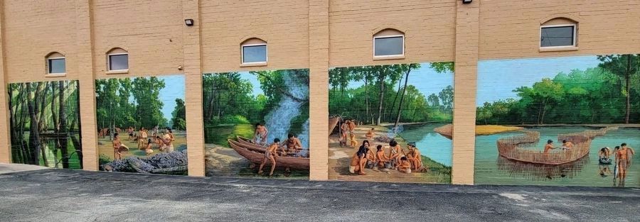
Mural by David Boatwright and Michael Kuffel, photographed by Rodney J. Harville
2. "River People" Mural

Regionally, this marker is in Georgia’s Coastal Plain. It is also in the American South and specifically in the Deep South. Globally, it is in North America, the Western Hemisphere, the Western World, and the Anglosphere. Historically, it finds itself in what was once the territory of the Mississippian Culture, one of the original Thirteen Colonies, one of the Confederate States of America, and the Antebellum South.
Other nearby markers. At least 8 other markers are within walking distance of this marker: Statesboro's First BBQ Restaurant (within shouting distance of this marker); Brannen Buildings (about 300 feet away, measured in a direct line); Blue Front (about 400 feet away); Vandy's Bar-B-Que (about 400 feet away); Corner of Banking (about 500 feet away); First Three Story Brick Building (about 500 feet away); Statesboro Buggy and Wagon Company (about 600 feet away); Bulloch County (about 600 feet away). Touch for a list and map of all markers in Statesboro.
Also see . . . Historical Society dedicates ‘River People’ murals. 2022 article by Al Hackle in the Statesboro Herald.
The Historical Society commissioned professional mural artists David Boatwright and Michael Kuffel, both from Charleston, South Carolina, to paint the murals at the end of December 2021 and concluding in January 2022.(Submitted on July 23, 2024.)
Credits. This page was last revised on October 27, 2024. It was originally submitted on July 18, 2024, by Rodney J. Harville of Statesboro, Georgia. This page has been viewed 419 times since then and 38 times this year. Photos: 1, 2. submitted on July 18, 2024. • Bernard Fisher was the editor who published this page.
