
Barrington in Bristol County, Rhode Island — The American Northeast (New England)
Bay Spring
Barrington's Industrial Center

"Campers all helped each other pitch tents, which had a big pole in the middle. The tents were up all summer long and Labor Day, down they'd come. There would be at least a hundred of them."
- Mary Clare Feeley, a summer resident of Bay Spring from 1928-1955
During the late-nineteenth and early-twentieth centuries, a summer colony of small cottages developed in Bay Spring. The railroad brought day visitors, cottage owners, and families who rented tents in a campground (at what is now Lavin's Marina on Narragansett Avenue) to enjoy the cool breezes off the Providence River, swim, boat, fish, dig clams, gather oysters, and dance at the Bay Spring Yacht Club.
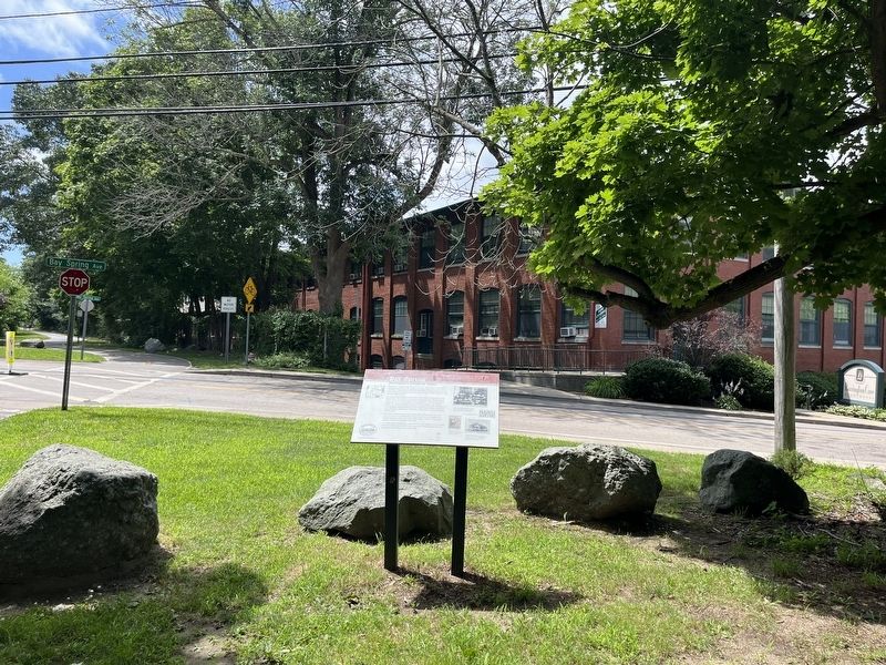
Bay Spring was also Barrington's industrial center. "Annawomscutt" Mill was built in several phases between 1905 and 1914. One of the brick buildings still stands on Bay Spring Avenue, significant as the last surviving industrial structure in Barrington. Initially a knitting mill, the building later housed a factory for dyeing and finishing cotton goods. In 1911, it became O'Bannon Mill, ultimately the largest manufacturer of imitation leather in the country,
this page online
Farther west on Bay Spring Avenue was the Rhode Island Lace Works, built in 1904. Here, fine lace for items such as wedding dresses, hat veils, and curtains was manufactured for customers around the world until the factory closed in 1990. The building was demolished thereafter, making way for an assisted living facility.
The brackish waters in Bullock's Cove created ideal conditions for oystering, another profitable industry. At one time there were three oyster houses there, helping to make Barrington the second largest oyster grower in Rhode Island in 1885.
[Captions:]
Workers from the O'Bannon Mill pose in this 1916 photo. The brick structure—visible from this sign—is the largest industrial building remaining from Barrington, and, since 1997, has served as senior housing.
Lace from Rhode Island Lace Works
Clamming was common in Bullock's Cove. Summer residents Hatti Clark and Alice Josselyn are shown circa 1910.
The Bay Spring Yacht Club was built circa 1910. Vacationers and local residents played billiards and card games on the lower level; dances and stage shows were held upstairs. the building was destroyed by the 1938 hurricane.
Erected by Barrington
Topics. This historical marker is listed in these topic lists: Animals • Industry & Commerce • Parks & Recreational Areas • Waterways & Vessels. A significant historical year for this entry is 1905.
Location. 41° 44.897′ N, 71° 20.694′ W. Marker is in Barrington, Rhode Island, in Bristol County. It is at the intersection of East Bay Bike Path and Bay Spring Avenue, on the right when traveling north on East Bay Bike Path. Touch for map. Marker is at or near this postal address: 85 Bay Spring Ave, Barrington RI 02806, United States of America. Touch for directions.

Regionally, this marker is in Greater Providence and on Narragansett Bay. It is also in the American Northeast, in New England, and on the Eastern Seaboard. Globally, it is in the North Atlantic Region, North America, the Western Hemisphere, the Western World, and the Anglosphere. Historically, it finds itself in what was once one of the original Thirteen Colonies.
Other nearby markers. At least 8 other markers are within 2 miles of this marker, measured as the crow flies: Drownville (approx. 0.2 miles away); a different marker also named Drownville (approx. ¼ mile away); Haines Park (approx. 0.4 miles away); Little Echo (approx. 0.8 miles away); Crescent Park Looff Carousel (approx. 0.9 miles away); Welcome to Sowams Woods (approx. 1.2 miles away); Thomas Willett 1610-1674 (approx. 1.3 miles away); Elizabeth Tilley Howland (approx. 1.3 miles away). Touch for a list and map of all markers in Barrington.
Credits. This page was last revised on July 20, 2024. It was originally submitted on July 20, 2024, by Devry Becker Jones of Washington, District of Columbia. This page has been viewed 354 times since then and 85 times this year. Photos: 1, 2. submitted on July 20, 2024, by Devry Becker Jones of Washington, District of Columbia.
