Nags Head in Dare County, North Carolina — The American South (South Atlantic)
Bodie Island Lighthouse
| — | Cape Hatteras National Seashore | — |
Photographed by Ray Gurganus, July 16, 2024
1. Bodie Island Lighthouse Marker
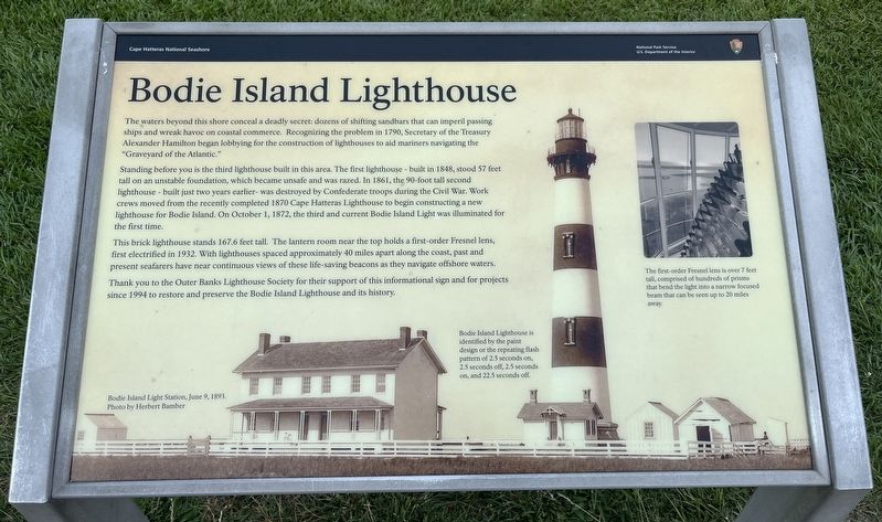
The waters beyond this shore conceal a deadly secret: dozens of shifting sandbars that can imperil passing ships and wreak havoc on coastal commerce. Recognizing the problem in 1790, Secretary of the Treasury Alexander Hamilton began lobbying for the construction of lighthouses to aid mariners navigating the "Graveyard of the Atlantic."
Standing before you is the third lighthouse built in this area. The first lighthouse - built in 1848, stood 57 feet tall on an unstable foundation, which became unsafe and was razed. In 1861, the 90-foot tall second lighthouse - built just two years earlier- was destroyed by Confederate troops during the Civil War. Work crews moved from the recently completed 1870 Cape Hatteras Lighthouse to begin constructing a new lighthouse for Bodie Island. On October 1, 1872, the third and current Bodie Island Light was illuminated for the first time.
This brick lighthouse stands 167.6 feet tall. The lantern room near the top holds a first-order Fresnel lens, first electrified in 1932. With lighthouses spaced approximately 40 miles apart along the coast, past and present seafarers have near
this page online
Thank you to the Outer Banks Lighthouse Society for their support of this informational sign and for projects since 1994 to restore and preserve the Bodie Island Lighthouse and its history.
(captions)
Bodie Island Light Station, June 9, 1893. Photo by Herbert Bamber
Bodie Island Lighthouse is identified by the paint design or the repeating flash pattern of 2.5 seconds on, 2.5 seconds off, 2.5 seconds on, and 22.5 seconds off.
The first-order Fresnel lens is over 7 feet tall, comprised of hundreds of prisms that bend the light into a narrow focused beam that can be seen up to 20 miles away.
Erected by National Park Service, U.S. Department of the Interior.
Topics and series. This historical marker is listed in these topic lists: Communications • War, US Civil • Waterways & Vessels. In addition, it is included in the Lighthouses series list. A significant historical date for this entry is October 1, 1872.
Location. 35° 49.095′ N, 75° 33.83′ W. Marker is in Nags Head, North Carolina, in Dare County. It can be reached from Bodie Island Lighthouse

Photographed by Tom Bosse, September 19, 2021
2. Bodie Island Lighthouse Marker

Regionally, this marker is in North Carolina’s Coastal Plain and on the Outer Banks. It is also in the American South, specifically in the Upper South, in the Tidewater, and on the Eastern Seaboard. Globally, it is in the North Atlantic Region, North America, the Western Hemisphere, the Western World, and the Anglosphere. Historically, it finds itself in what was once the territory of the Mississippian Culture, one of the original Thirteen Colonies, one of the Confederate States of America, and the Antebellum South.
Other nearby markers. At least 8 other markers are within 8 miles of this marker, measured as the crow flies: All for Safe Passage (a few steps from this marker); Bodie Island Light Station (about 300 feet away, measured in a direct line); A Hunter's Paradise (approx. 0.2 miles away); Giant Bluefin Tuna (approx. 1.7 miles away);

Photographed by Tom Bosse, September 19, 2021
3. Bodie Island Lighthouse
Other markers no longer nearby. Bodie Island Lighthouse (has been replaced with this marker); Port Ferdinando (was approx. 1.4 miles away but has been confirmed missing).
Related marker. Click here for another marker that is related to this marker. Old Marker At This Location also titled "Bodie Island Lighthouse".
Also see . . . Bodie Island Light Station. National Park Service (Submitted on July 23, 2024.)
Credits. This page was last revised on July 23, 2024. It was originally submitted on July 23, 2024, by Ray Gurganus of Washington, District of Columbia. This page has been viewed 361 times since then and 36 times this year. Photos: 1. submitted on July 21, 2024, by Ray Gurganus of Washington, District of Columbia. 2, 3. submitted on January 24, 2022, by Tom Bosse of Jefferson City, Tennessee. • Bernard Fisher was the editor who published this page.
