Weissport in Carbon County, Pennsylvania — The American Northeast (Mid-Atlantic)
Franklin's Week in Weissport
In 1756, America's great statesman was this area's 'director of homeland security'
| — | by Jim Zbick | — |
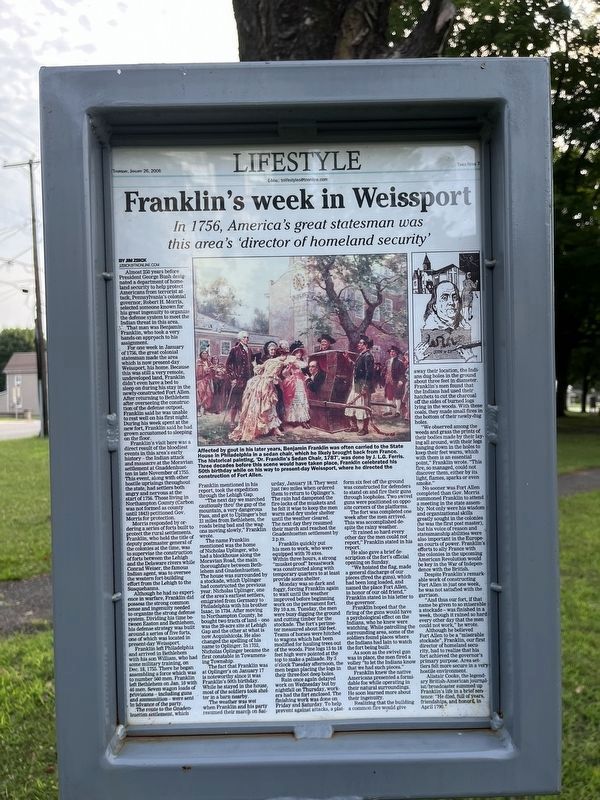
Almost 250 years before President George Bush designated a department of homeland security to help protect Americans from terrorist attack, Pennsylvania's colonial governor, Robert H. Morris, selected someone known for his great ingenuity to organize the defense system to meet the Indian threat in this area.
,br> That man was Benjamin Franklin, who took a very hands-on approach to his assignment.
For one week in January of 1756, the great colonial statesman made the area which is now present day Weissport, his home. Because this was still a very remote, undeveloped land, Franklin didn't even have a bed to sleep on during his stay in the newly-constructed Fort Allen. After returning to Bethlehem after overseeing the construction of the defense outpost, Franklin said he was unable to rest well on his first night. During his week spent at the new fort, Franklin said he had grown accustomed to sleeping on the floor.
Franklin's visit here was a direct result of the bloodiest events in this area's early history — the Indian attack and massacre at the Moravian settlement at Gnaddenhuetten in late November of 1755. This
this page online
Although he had no experience in warfare, Franklin did possess the strong common sense and ingenuity needed to organize the strong defense system. Dividing his time between Easton and Bethlehem, his defense strategy was built around a series of five forts, one of which was located in present-day Weissport.
Franklin left Philadelphia and arrived in Bethlehem with his son William, who had some military training, on Dec. 18, 1755. There he began assembling a force which was to number 560 men. Franklin left
The route to the Gnadenhuetten settlement, which Franklin mentioned in his report, took the expedition through the Lehigh Gap.
"The next day we marched cautiously thro' the gap of the mountain, a very dangerous Pass, and got to Uplinger's but 21 miles from Bethlehem, the roads being bad and the wagons moving slowly," Franklin wrote.
The name Franklin mentioned was the home of Nicholas Uplinger, who had a blockhouse along the Moravian Road, the main thoroughfare between Bethlehem and Gnadenhuetten. The house was surrounded by a stockade, which Uplinger had constructed the previous year. Nicholas Uplinger, one of the area's earliest settlers, emigrated from Germany to Philadelphia with his brother Isaac, in 1734. After moving to Northampton County, he bought two tracts of land — one was the 29-acre site at Lehigh Gap and the other at what is now Acquishicola. He also changed the spelling of his name to Oplinger. In 1752, Nicholas Oplinger became the first constable in Towamensing Township.
The fact that Franklin was at Oplinger's on January 17 is noteworthy since it was Franklin's 50th birthday. While he stayed in the house, most of the soldiers took shelter in a barn nearby.
The weather was wet when Franklin and his party resumed their march on Saturday, January 18. They went just two miles when ordered them to return to Oplinger's. The rain had dampened the fire-locks of the muskets and he felt it wise to keep the men warm and dry under shelter until the weather cleared. The next day they resumed their march and reached Gnadenhuetten settlement by 2 p.m.
Franklin quickly put his men to work, who were equipped with 70 axes. Within three hours, a strong "musket-proof" breastwork was constructed along with temporary quarters to at least provide some shelter.
Monday was so dark and foggy, forcing Franklin again to wait until the weather improved before beginning work on the permanent fort. By 10 a.m. Tuesday, the men were busy digging the ground and cutting timber for the stockade. The fort's perimeter measured about 350 feet. Teams of horses were hitched to wagons which had been modified for hauling trees out of the woods. Pine logs 15 to 18 feet high were pointed at the top to make a palisade. By 3 o'clock Tuesday afternoon, the men began placing the logs in their three-foot deep holes.
Rain once again delayed work on Wednesday but by nightfall on Thursday, workers had the fort enclosed. The finishing work was done on Friday and Saturday. To help prevent against attacks, a platform six feet off the ground was constructed for defenders to stand on and fire their guns through loopholes. Two swivel guns were positioned on opposite corners of the platforms.
The fort was completed one week after the men arrived. This was accomplished despite the rainy weather.
"It rained so hard every other day the men could not report," Franklin stated in his report.
He also gave a brief description of the fort's official opening on Sunday.
"We hoisted the flag, made a general discharge of our pieces (fired the guns), which had been long loaded, and named the place Fort Allen, in honor of our old friend," Franklin stated in his letter to the governor.
Franklin hoped that the firing of the guns would have a psychological effect on the Indians, who we knew were watching. While patrolling the surrounding area, some of the soldiers found places where the Indians had lain to watch the fort being built.
As soon as the swivel gun was in place, the men fired a volley "to let the Indians known that we had such pieces."
Franklin knew the native Americans presented a formidable foe while operating in their natural surroundings. He soon learned more about their ingenuity.
Realizing that the building a common fire would give away their location, the Indians dug holes in the ground about three feet in diameter. Franklin's men found that the Indians had used their hatchets to cut the charcoal off the sides of burned logs lying in the woods. With these coals, they made small fires in the bottom of their newly-dug holes.
"We observed among the weeds and grass the prints of their bodies made by their laying all around, with their legs hanging down in the holes to keep their feet warm, which with them is an essential point," Franklin wrote. This fire, so managed, could not discover them, either by its light, flames, sparks or even smoke."
No sooner was Fort Allen completed than Gov. Morris summoned Franklin to attend a meeting in the state assembly. Not only were his wisdom and organizational skills greatly sought in the colonies (he was the first postmaster), but his voice of reason and statesmanship abilities were also important in the European courts of power. Franklin's efforts to ally France with the colonies in the upcoming American Revolution would be key in the War of Independence with the British.
Despite Franklin's remarkable work of constructing Fort Allen in just one week, he was not satisfied with the garrison.
"And thus our fort, if that name be given to so miserable a stockade — was finished in a week, though it rained so hard every other day that the men could not work," he wrote.
Although he believed Fort Allen to be a "miserable stockade", Franklin, our first director of homeland security, had to realize that his for achieved the governor's primary purpose. Area settlers felt more secure in a very hostile environment.
Alistair Cooke, the legendary British-American journalist/broadcaster summed up Franklin's life in a brief sentence: "He died, full of years, friendships, and honors in April 1790."
Topics. This historical marker is listed in these topic lists: Colonial Era • Forts and Castles • Indigenous Peoples and Communities • Settlements & Settlers. A significant historical date for this entry is December 18, 1755.
Location. 40° 49.782′ N, 75° 42.146′ W. Marker is in Weissport, Pennsylvania, in Carbon County. It is at the intersection of Franklin Street and Bridge Street, on the right when traveling north on Franklin Street. Touch for map. Marker is at or near this postal address: 108 Franklin St, Lehighton PA 18235, United States of America. Touch for directions.

Regionally, this marker is in Anthracite Coal Region and in the Pocono Mountains. It is also in the American Northeast, in the Mid-Atlantic, in Appalachia, and specifically in Northern Appalachia. Globally, it is in North America, the Western Hemisphere, the Western World, and the Anglosphere. Historically, it finds itself in what was once the Haudenosaunee (Iroquois) Confederacy and also one of the original Thirteen Colonies.
Other nearby markers. At least 8 other markers are within walking distance of this marker: Fort Allen Well (here, next to this marker); Fort Allen (a few steps from this marker); Betty Mullen Brey (within shouting distance of this marker); a different marker also named Betty Mullen Brey (within shouting distance of this marker); a different marker also named Betty Mullen Brey (within shouting distance of this marker); National War Savings Campaign of 1918 (about 300 feet away, measured in a direct line); Jacob Weiss Memorial (about 300 feet away); a different marker also named Fort Allen (about 700 feet away). Touch for a list and map of all markers in Weissport.
Credits. This page was last revised on July 23, 2024. It was originally submitted on July 23, 2024, by Devry Becker Jones of Washington, District of Columbia. This page has been viewed 255 times since then and 54 times this year. Photos: 1, 2. submitted on July 23, 2024, by Devry Becker Jones of Washington, District of Columbia.
