Port Stanley in Elgin County, Ontario — Central Canada (North America)
Col. John Bostwick
Veteran of the War of 1812

Photographed by Tim Boyd, July 27, 2024
1. Col. John Bostwick Marker
During the war Bostwick served as the captain of a flank company in the Norfolk militia, The flank companies received better arms and training than the regular militia and consequently saw more action. He was present at the fall of Detroit, August 16, 1812, and must have performed well as General Sir Isaac Brock told Col. Talbot, who commanded the district militia, that "You cannot send a better Captain than (Bostwick)."
His brother Henry was Lieutenant-colonel of the Oxford militia and was in command at Malcolm's Mills on November 6, 1814, when the militia and
this page online
In 1817, Bostwick built a home near the mouth of the Kettle Creek and then in the 1820s built the house that still stands on a hill overlooking the village. The construction is a rare exampte of brick-nogging where a pegged timber frame is filled with brick.
The brick was undoubtedly fired on the site. The village developed slowly while Bostwick held the land. A harbour was built and it became a shipping point for merchants using the plank road leading to St. Thomas and London.
Erected by Elgin County Historical Society.
Topics. This historical marker is listed in these topic lists: Colonial Era • Roads & Vehicles • Settlements & Settlers • War of 1812. A significant historical date for this entry is August 16, 1812.
Location. 42° 40.245′ N, 81° 12.801′ W. Marker is in Port Stanley, Ontario, in Elgin County. It is at the intersection of Colborne Street and Matilda Street,

Photographed by Tim Boyd, July 27, 2024
2. Col. John Bostwick Marker

Regionally, this marker is in the Southwest Ontario Area and in Southwestern Ontario. It is also in Central Canada. Globally, it is in North America, on the Great Lakes, in the Western Hemisphere, in the Western World, and in the Anglosphere. Historically, it finds itself in what was once a British colony, the Viceroyalty of New France, the Haudenosaunee (Iroquois) Confederacy, and Rupert’s Land.
Other nearby markers. At least 8 other markers are within 11 kilometers of this marker, measured as the crow flies: Lieut.-Col. John Bostwick (a few steps from this marker); Port Stanley (approx. 0.6 kilometers away); Commemoration of Port Stanley Harbour (approx. 0.6 kilometers away); The Telegraph Office and the Traction Line (approx. 0.6 kilometers away); The London and Port Stanley Railroad / Le Chemin de Fer London and Port Stanley (approx. 0.6 kilometers away); Bridges (approx.

3. Col. John Bostwick marker photo detail
Also see . . . Dictionary of Canadian Biography - Bostwick, John.
At the outbreak of the War of 1812 Bostwick volunteered for service. As captain of a flank company of the 1st Norfolk Militia, he quickly acquired experience at the capture of Detroit in August 1812. In September Major-General Isaac Brock, in a request for reinforcements from Talbot, who supervised the militia in the London District, declared, “You cannot send a better Capt. than Bothwick.” Two months later his company took part in the battle of Frenchman Creek, near Fort Erie, suffering severe losses and earning the praise of Lieutenant-Colonel Cecil Bisshopp. At Nanticoke 12 months later, after British regulars had withdrawn to the head of Lake Ontario, Bostwick narrowly escaped being shot in the capture of a band of marauders by a volunteer force under his brother Henry.(Submitted on July 31, 2024, by Tim Boyd of Hamilton, Ontario.)

4. Col. John Bostwick marker detail

5. Col. John Bostwick marker photos detail
Photographed by Tim Boyd, July 27, 2024
6. Col. John Bostwick marker detail
Text:
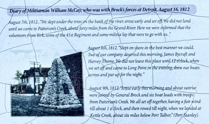
Diary of Militiaman William McCay, who was with Brocks forces at Detroit, August 16, 1812
August 7th, 1812. "We slept under the trees on the bank of the river, arose early and set off He did not land until we came to Patterson's Creek, about forty miles from the Grand River. Here we were informed that the volunteers from York, some of the 4lst Regiment and some militia lay that were to go with us."
August 8th, 1812. "Slept on shore in the best manner we could.
Two of our company deserted this morning, James Bycraft and Harvey Thome. Ile did not leave this place until 12 o’clock, when we set off and came to Long Point in the evening, drew our boats across and put up for the night."
August 9th, 1812. Arose early this morning and about sunrise were joined by General Brock and six boat loads with troops from Patterson's Creek. We all set off together, having a fair wind till about 1 o'clock, and then rowed till night, when we laded at Kettle Creek, about six miles below Port Talbot." (Port Stanley)
Credits. This page was last revised on July 31, 2024. It was originally submitted on July 31, 2024, by Tim Boyd of Hamilton, Ontario. This page has been viewed 360 times since then and 126 times this year. Photos: 1, 2, 3, 4, 5, 6. submitted on July 31, 2024, by Tim Boyd of Hamilton, Ontario. • Andrew Ruppenstein was the editor who published this page.
