Marker Logo
THE HISTORICAL
MARKER DATABASE
“Bite-Size Bits of Local, National, and Global History”
Hatteras in Dare County, North Carolina — The American South (South Atlantic)
 

Fort Clark
⎯⎯⎯
The Bombardment of Fort Hatteras
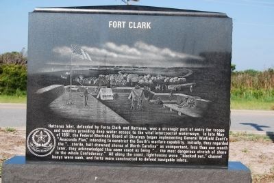
 
 
Fort Clark Marker image. Click for full size.
Photographed by Mike Wintermantel, August 16, 2011
1. Fort Clark Marker
Inscription.
Side A:
Fort Clark
Hatteras Inlet, defended by Forts Clark and Hatteras, was a strategic port of entry for troops and supplies providing deep water access to the vital intercoastal waterways. In later May of 1861, the Federal Blockade Board of Strategy began implementing General Winfield Scott's "Anaconda Plan" intending to constrict the South's warfare capability. Initially, they regarded the "...sterile, half drowned shores of North Carolina" as unimportant; less than one month later, they acknowledged this same coast as being "...the most dangerous stretch of shore in the whole Confederacy." All along the coast, lighthouses were "blacked out," channel buoys were sunk, and forts were constructed to defend navigable inlets.

Side B:
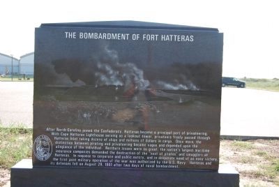
The Bombardment of Fort Hatteras
After North Carolina joined the Confederacy, Hatteras became a principal port of privateering. With Cape Hatteras Lighthouse serving as a lookout tower, privateers freely passed through Hatteras Inlet taking dozens of ships and millions of dollars in cargo. Once more, the distinction between pirating and privateering became vague and depended upon the allegiance
Paid Advertisement
Click or scan to see
this page online
of the individual. Northern losses were so great, the nation's largest maritime insurance companies demanded the destruction of the "nest of pirates" and smugglers at Hatteras. In response to corporate and public outcry, and in desperate need of an easy victory, the first joint military operation of the war was authorized by the United States Navy. Hatteras and its defenses fell on August 29, 1861 after two days of naval bombardment.
 
Topics. This historical marker is listed in these topic lists: War, US CivilWaterways & Vessels. A significant historical year for this entry is 1861.
 
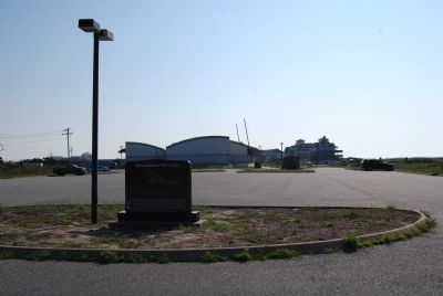
Location. 35° 12.354′ N, 75° 42.341′ W. Marker is in Hatteras, North Carolina, in Dare County. It can be reached from Museum Drive 0.2 miles west of Coast Guard Road. Located in parking lot of Graveyard of the Atlantic Museum. Part of the Hatteras Village Guided Tour. Touch for map. Marker is in this post office area: Hatteras NC 27943, United States of America. Touch for directions.

Regionally, this marker is in North Carolina’s Coastal Plain and on the Outer Banks. It is also in the American South, specifically in the Upper South, and in
The Bombardment of Fort Hatteras Marker image. Click for full size.
Photographed by Mike Wintermantel, August 16, 2011
2. The Bombardment of Fort Hatteras Marker
the Tidewater. Globally, it is in the North Atlantic Region, North America, the Western Hemisphere, the Western World, and the Anglosphere. Historically, it finds itself in what was once the territory of the Mississippian Culture, one of the original Thirteen Colonies, one of the Confederate States of America, and the Antebellum South.

Other nearby markers. At least 8 other markers are within 2 miles of this marker, measured as the crow flies: Burnside's Expedition Crossing Hatteras Bar/The Burnside Expedition at Hatteras Inlet (a few steps from this marker); Maritime Casualties of the American Civil War/Loss of the USS Monitor (within shouting distance of this marker); Flagship USS Minnesota/Hotel de Afrique (about 300 feet away, measured in a direct line); U-boats Off North Carolina's Coast (about 500 feet away); Propeller From USS Dionysus (approx. 0.2 miles away); Welcome to captivating Hatteras Island… (approx. 0.2 miles away); Confederate Forts (approx. Ό mile away); Storm Watch (approx. 1.3 miles away). Touch for a list and map of all markers in Hatteras.
 
Also see . . .  Battle of Hatteras Inlet Batteries at Wikipedia.
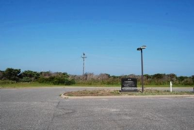
Fort Clark Marker image. Click for full size.
Photographed by Mike Wintermantel, August 16, 2011
3. Fort Clark Marker
(Submitted on November 7, 2024, by Mike McKeown of Baltimore, Maryland.)
 
The Bombardment of Fort Hatteras Marker image. Click for full size.
Photographed by Mike Wintermantel, August 16, 2011
4. The Bombardment of Fort Hatteras Marker
 
 
Credits. This page was last revised on January 7, 2025. It was originally submitted on August 21, 2011, by Mike Wintermantel of Pittsburgh, Pennsylvania. This page has been viewed 2,420 times since then and 54 times this year. Last updated on August 3, 2024, by Mark St. Martin of Kalamazoo, Michigan. Photos:   1, 2, 3, 4. submitted on August 21, 2011, by Mike Wintermantel of Pittsburgh, Pennsylvania. • Bernard Fisher was the editor who published this page.

m=253140

CeraNet Cloud Computing sponsors the Historical Marker Database.
This website earns income from purchases you make after using our links to Amazon.com. We appreciate your support.
Paid Advertisement
Jul. 9, 2026