
Dubois in Clark County, Idaho — The American West (Mountains)
Fort Henry Historic Byway
| — | Lost Gold Scenic Trails | — |
Photographed by Cosmos Mariner, July 7, 2024
1. Fort Henry Historic Byway Marker
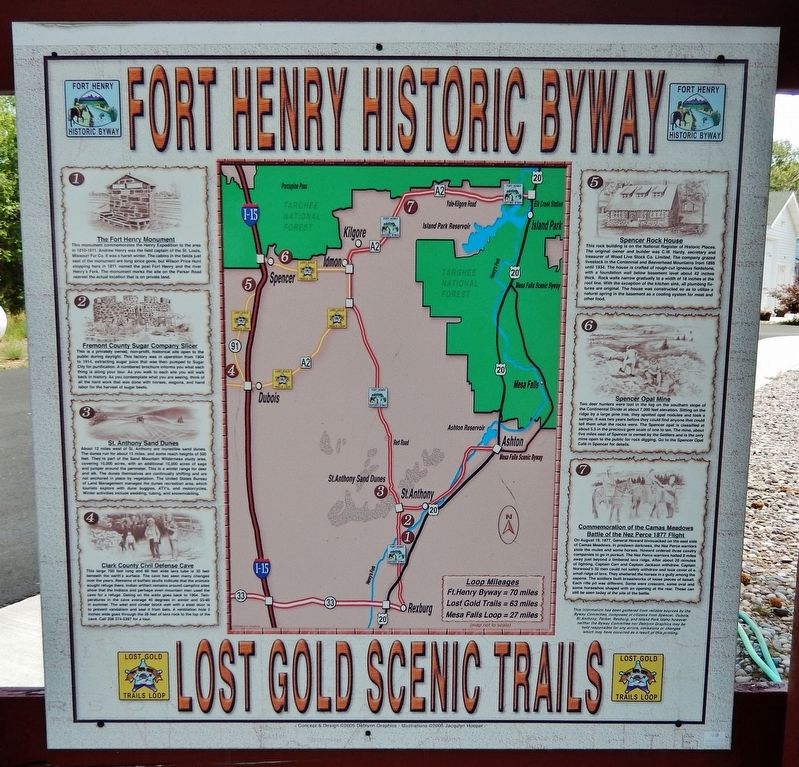
1 • The Fort Henry Monument
This monument commemorates the Henry Expedition to the area in 1810-1811. Andrew Henry was the field captain of the St. Louis, Missouri Fur Co. it was a harsh winter. The cabins in the fields just east of the monument are long since gone, but Wilson Price Hunt stopping here in 1811 named the post Fort Henry and the river Henry's Fork. The monument marks the site on the Parker Road nearest the actual location that is on private land.
2 • Fremont County Sugar Company Slicer
This is a privately owned, non-profit, historical site open to the public during daylight. This factory was in operation from 1904 to 1914, extracting sugar juice that was then pumped to Sugar City for purification. A numbered brochure informs you what each thing is along your tour. As you walk to each site you will walk back in history. As you contemplate what you are seeing, think of all the hard work that was done with horses, wagons and hand labor for the harvest of sugar beets.
3 • St. Anthony Sand Dunes
About 12 miles west of St. Anthony are incredible sand dunes. The dunes run for about 15 miles, and some reach heights of
this page online
4 • Clark County Civil Defense Cave
This large 700 feet long and 60 feet wide lava tube, is 35 feet beneath the earth's surface. The cave has seen many changes over the years. Remains of buffalo skulls indicate that the animals sought refuge there. Indian artifact remains around campfire sites show that the Indians and perhaps even mountain men used the cave for a refuge. Dating on the walls goes back to 1904. Temperatures in the cave average 40 degrees in winter and 55-60 in summer. The west end cinder block wall with a steel door is to prevent vandalism and seal it from bats. A ventilation hole 5 inches wide goes through the 26 feet of lava
Photographed by Cosmos Mariner, July 7, 2024
2. Fort Henry Historic Byway Marker
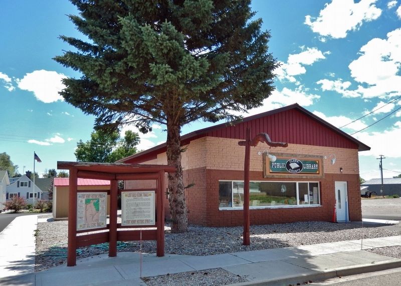
The marker is mounted on the left side of this Fort Henry Historic Byway interpretive kiosk. Clark County Public Library is in the right background.
5 • Spencer Rock House
This rock building is on the National Register of Historic Places. The original owner and builder was C.W. Hardy, secretary and treasurer of Wood Live Stock Co. Limited. The company grazed livestock in the Centennial and Beaverhead Mountains from 1895 until 1934. The house is crafted of rough-cut igneous fieldstone, with a foundation wall below basement level about 42 inches thick. Rock walls narrow gradually to a width of 18 inches at the roof line. With the exception of the kitchen sink, all plumbing fixtures are original. The house was constructed so as to utilize a natural spring in the basement as a cooling system for meat and other food.
6 • Spencer Opal Mine
Two deer hunters were lost in the fog on the southern slope of the Continental Divide at about 7,000 feet elevation. Sitting on the ridge by a large pine tree, they spotted opal nodules and took a sample. It was two years before they could find anyone that could tell them what the rocks were. The Spencer opal is classified at about 5.5 in the precious gem scale of one to ten. The mine, about five
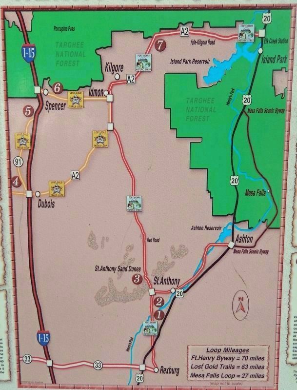
3. Marker detail: Historic Byways Map
Ft. Henry Byway = 70 miles
Lost Gold Trails = 63 miles
Mesa Falls Loop = 27 miles
7 • Commemoration of the Camas Meadows Battle of the Nez Perce 1877 Flight
On August 19, 1877, General Howard bivouacked on the east side of Camas Meadows. In predawn darkness, the Nez Perce warriors stole the mules and some horses. Howard ordered three cavalry companies to go in pursuit. The Nez Perce warriors halted 8 miles away just beyond a timbered lava ridge. After about 20 minutes of fighting, Captain Carr and Captain Jackson withdrew. Captain Norwood's 35 men could not safely withdraw and took cover of a small ridge of lava. They sheltered the horses in a gully among the aspens. The soldiers built breastworks of loose pieces of basalt. Each rifle pit was different. Some were crescent, some oval and some horseshoe shaped with an opening at the rear. These can still be seen today at the site of the battle.
This information has been gathered from reliable sources by the Byway Committee, composed of citizens from Spencer, Dubois, St. Anthony, Parker, Rexburg, and Island Park Idaho however neither the Byway Committee nor Deblynn Graphics may be held responsible for any errors, omissions or changes which may have occurred as a result of this printing.
Topics. This historical marker is listed in these topic lists: Indigenous Peoples and Communities • Industry & Commerce • Roads & Vehicles • Settlements & Settlers. A significant historical date for this entry is August 19, 1877.
Location. 44° 10.568′ N, 112° 13.755′ W. Marker is in Dubois, Idaho, in Clark County. It is on Main Street (County Road A-2) just east of Center Street, on the right when traveling east. The marker is mounted on the left side of the Fort Henry Historic Byway interpretive kiosk in front of the Clark County Public Library. Touch for map. Marker is at or near this postal address: 21 Main Street, Dubois ID 83423, United States of America. Touch for directions.

Regionally, this marker is in Central Idaho — Sawtooth Range. It is also in the American Mountain West. Globally, it is in North America, the Rocky Mountains, the Western Hemisphere, the Western World, and the Anglosphere.
Other nearby markers. At least 2 other markers are within walking distance of this marker: Lost Gold Scenic Trails (here, next to this marker); Nez Perce War (approx. half a mile away).
Related markers. Click here for a list of markers that are related to this marker. Fort Henry Historic Byway
Credits. This page was last revised on December 28, 2024. It was originally submitted on August 5, 2024, by Cosmos Mariner of Cape Canaveral, Florida. This page has been viewed 617 times since then and 84 times this year. Photos: 1, 2, 3. submitted on August 5, 2024, by Cosmos Mariner of Cape Canaveral, Florida.
