Near White Post in Clarke County, Virginia — The American South (Mid-Atlantic)
Double Tollgate
Photographed by Craig Swain, July 15, 2007
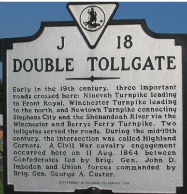
1. Double Tollgate Marker
Early in the 19th century, three important roads crossed here: Nineveh Turnpike leading to Front Royal, Winchester Turnpike leading to the north, and Newton Turnpike connecting Stephens City and the Shenandoah River via the Winchester and Berrys Ferry Turnpike. Two tollgates served the roads. During the mid-19th century, the intersection was called Highland Corners. A Civil War cavalry engagement occurred here on 11 Aug. 1864 between Confederates led by Brig. Gen. John D. Imboden and Union forces commanded by Brig. Gen. George A. Custer.
Erected 1999 by Department of Historic Resources. (Marker Number J-18.)
Topics and series. This historical marker is listed in these topic lists: Landmarks • Roads & Vehicles • War, US Civil. In addition, it is included in the Virginia Department of Historic Resources (DHR) series list. A significant historical date for this entry is August 11, 1864.
Location. 39° 3.605′ N, 78° 8.336′ W. Marker is near White Post, Virginia, in Clarke County. It is at the intersection of Stonewall Jackson Highway (U.S. 522) and Lord Fairfax Parkway (U.S. 340) on Stonewall Jackson Highway. Touch for map.
this page online

Regionally, this marker is in the Washington Metropolitan Area and in Northern Virginia. It is also in the American South, specifically in the Upper South, and in the Mid-Atlantic. Globally, it is in North America, the Western Hemisphere, the Western World, and the Anglosphere. Historically, it finds itself in what was once the territory of the Mississippian Culture, one of the original Thirteen Colonies, one of the Confederate States of America, and the Antebellum South.
Other nearby markers. At least 8 other markers are within 4 miles of this marker, measured as the crow flies: Double Tollgate Fight (about 400 feet away, measured in a direct line); Clark County / Frederick County (approx. half a mile away); Greenway Court (approx. 1½ miles away); 1750 A.D. (approx. 1.9 miles away); White Post (approx. 2 miles away); a different marker also named Clark County / Frederick County (approx. 3.1 miles away); The Ritenour Family (approx. 3.2 miles away); a different marker also named
Photographed by Craig Swain, July 15, 2007
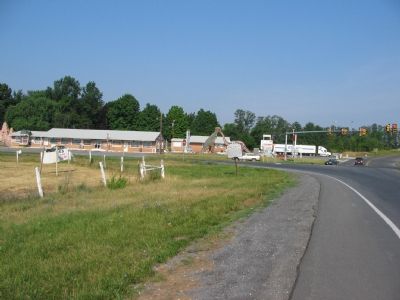
2. Double Tollgate Still a Crossroads
The historical names for the roads have given way to Stonewall Jackson Highway and Lord Fairfax Parkway, but the road beds still cross here, and traffic remains heavy.
Another marker is no longer nearby. Defenses of Winchester (was approx. 3.3 miles away but has been replaced with another marker now near it).
Regarding Double Tollgate. Double Tollgate is an unincorporated community in Clarke County, Virginia. Double Tollgate is located at the intersection of Fairfax Pike (State Route 277), Front Royal Pike (U.S. Route 522), Lord Fairfax Highway (U.S. Route 340), and Stonewall Jackson Highway (U.S. Routes 340 and 522). (Entire Wikipedia entry)
Also see . . . Dinosaur Land. A throwback to the old days of roadside tourist stops, Dinosaurland stands on the other side of the intersection from the marker. (Submitted on July 17, 2007, by Craig Swain of Leesburg, Virginia.)
Photographed by Craig Swain, July 15, 2007
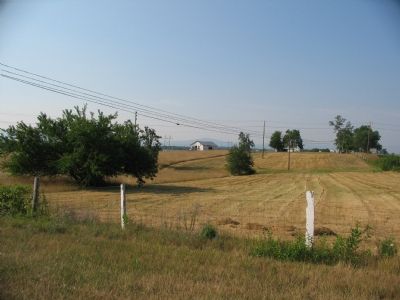
3. Battle of Double Tollgate
After a day of maneuvering and skirmishing, Gen. Custer withdrew from Double Tollgate, ending a bid to outflank Gen. Jubal Early's army located at Winchester. Some of the Confederate lines ran in the fields to the southeast of the marker.
Credits. This page was last revised on August 7, 2024. It was originally submitted on July 17, 2007, by Craig Swain of Leesburg, Virginia. This page has been viewed 6,472 times since then and 351 times this year. Last updated on August 6, 2024, by Carl Gordon Moore Jr. of North East, Maryland. Photos: 1, 2, 3. submitted on July 17, 2007, by Craig Swain of Leesburg, Virginia. • Devry Becker Jones was the editor who published this page.
