
Bedford-Stuyvesant in Brooklyn in Kings County, New York — The American Northeast (Mid-Atlantic)
Hattie Carthan Playground
0.982 acre
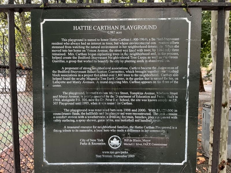
This playground is named to honor Hattie Carthan (1900-1984), a Bedford-Stuyvesant resident who always had an interest in trees, but whose environmental conservation efforts stemmed from watching the natural environment in her neighborhood deteriorate. When she moved into her home on Vernon Avenue, the street was lined with trees; by 1964 only three remained. Mrs. Carthan began replanting trees in the neighborhood and, in the process, helped create the Bedford-Stuyvesant Neighborhood Tree Corps as well as the Green Guerillas, a group that worked to beautify the city by planting seeds in abandoned lots.
A proponent of strong neighborhood associations, Carthan became the chairwoman of the Bedford-Stuyvesant Beautification Committee, which brought together one hundred block associations in a project that added over 1,500 trees to the neighborhood. Carthan also helped found the nearby Magnolia Tree Earth Center, in the garden that is named for her, on Lafayette and Marcy Avenues. A mural depicting Mrs. Carthan appears on the front of the center.
The playground, located between Monroe Street, Tompkins Avenue, Madison
this page online
The playground was renovated between 1998 and 2000. With $1,123,000 in councilmanic funds, the ballfields and the playground were reconstructed. The park contains a comfort station with a weathevane, a drinking fountain, benches, play equipment with safety surfacing, a spray shower, game tables, and basketball and handball courts.
A treasured resource for neighborhood families, the Hattie Carthan Playground is a fitting tribute to its namesake, a local hero who made a difference in her community.
Erected 2009 by City of New York Parks & Recreation (NYC Parks).
Topics and series. This historical marker is listed in these topic lists: African Americans • Horticulture & Forestry • Parks & Recreational Areas • Women. In addition, it is included in the NYC Parks series list. A significant historical year for this entry is 1964.
Location. 40° 41.152′ N, 73° 56.784′ W. Marker is in

Regionally, this marker is in New York City. It is also in the American Northeast and on the Eastern Seaboard. Globally, it is in North America and the Western World. Historically, it finds itself in what was once one of the original Thirteen Colonies.
Other nearby markers. At least 8 other markers are within walking distance of this marker: Herbert Von King Park (approx. ¼ mile away); Banneker Playground (approx. 0.4 miles away); World War I Memorial (approx. 0.6 miles away); Classon FulGate Block Association Garden (approx. 0.7 miles away); Ulysses S. Grant (approx. 0.7 miles away); Eleanor Roosevelt Playground (approx. 0.7 miles away); a different marker also named Charles C. Pinn Triangle (approx. ¾ mile away); The Shoe Factory Building (approx. 0.8 miles away). Touch for a list and map of all markers in Brooklyn.
Another marker is
Credits. This page was last revised on August 11, 2024. It was originally submitted on August 11, 2024, by Devry Becker Jones of Washington, District of Columbia. This page has been viewed 247 times since then and 30 times this year. Photos: 1, 2, 3. submitted on August 11, 2024, by Devry Becker Jones of Washington, District of Columbia.
