Williamsburg in Whitley County, Kentucky — The American South (East South Central)
Loyal Land Company in Kentucky
⎯⎯⎯
Early Surveying

Photographed by Dave W, June 8, 2024
1. Loyal Land Company in Kentucky side of marker
Loyal Land Company in Kentucky
Walker and the party were employed by the Loyal Land Company, which formed in Virginia in 1749 to survey 800,000 acres west of the Allegheny Mountains, along the southern border of Virginia. The area was home to Indigenous Americans from the Shawnee, Mingo. Cherokee & Tutelo groups, who traded with the surveyors until the Seven Years War began in 1754.
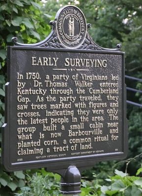
Early Surveying
In 1750, a party of Virginians led by Dr. Thomas Walker entered Kentucky through the Cumberland Gap. As the party traveled, they saw trees marked with figures and crosses, indicating they were only the latest people in the area. The group built a small cabin near what is now Barbourville and planted corn, a common ritual for claiming a tract of land.
Erected 2022 by Kentucky Historical Society / Kentucky Department of Highways. (Marker Number 898.)
Topics. This historical marker is listed in these topic lists: Environment • Exploration • Indigenous Peoples and Communities • Settlements & Settlers. A significant historical year for this entry is 1749.
Location. 36° 46.058′ N, 84° 9.043′ W. Marker is in Williamsburg,
this page online

Regionally, this marker is in Eastern Kentucky and in the Cumberland Plateau. It is also in the American South, specifically in the Upper South, in Appalachia, and specifically in Southern Appalachia. Globally, it is in North America, the Western Hemisphere, the Western World, and the Anglosphere. Historically, it finds itself in what was once the territory of the Mississippian Culture and also the Antebellum South.
Other nearby markers. At least 8 other markers are within 3 miles of this marker, measured as the crow flies: Samuel Cox, 1756-1832 (approx. 1.7 miles away); County Named, 1818 (approx. 1.7 miles away); Scott's Raid (approx. 1.7 miles away); "Aunt Julia" Marcum (approx. 1.8 miles away); Clyde V. and Patricia Bennett Building (approx. 2.2 miles away); Roburn Hall (approx. 2.2 miles away); Cumberland College (approx. 2.3 miles away); Roy Martis Chappell (approx. 2.7 miles away). Touch for a list and map of
Photographed by Dave W, June 8, 2024
2. Early Surveying side of marker
Other markers no longer nearby. First White Men Here (was within shouting distance of this marker but has been permanently removed); Mahan Hall (was approx. 2.1 miles away but has been confirmed missing); Gillespie Hall (was approx. 2.2 miles away but has been confirmed missing).

Photographed by Dave W, June 8, 2024
3. Loyal Land Company in Kentucky / Early Surveying Marker
Credits. This page was last revised on August 12, 2024. It was originally submitted on August 12, 2024, by Dave W of Co, Colorado. This page has been viewed 354 times since then and 37 times this year. Photos: 1, 2, 3. submitted on August 12, 2024, by Dave W of Co, Colorado. • James Hulse was the editor who published this page.
