Marker Logo
THE HISTORICAL
MARKER DATABASE
“Bite-Size Bits of Local, National, and Global History”
Near Jean in Young County, Texas — The American South (West South Central)
 

Site of Cottonwood Spring
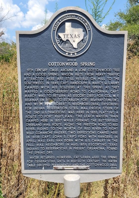
 
 
Site of Cottonwood Spring Marker image. Click for full size.
Photographed by James Hulse, July 25, 2024
1. Site of Cottonwood Spring Marker
Inscription. 19th century oasis around a lone cottonwood tree and a good spring. Wagon ruts from heavy traffic attracted here are still visible on hill to the southwest. In 1849, Capt. Randolph B. Marcy, U.S. Army, camped with his soldiers at this spring as they mapped a gold-seekers' road to California. Capt. Marcy was to return as escort (1851) for Col. W.F. Belknap, en route to establish Fort Belknap (15 mi. SW), and with Maj. Robert S. Neighbors (1854), exploring for Indian reservation sites. Maj. Enoch Steen of the 2nd U.S. Dragoons was here in 1855, platting a route to Fort Riley, Kan. The Leach wagon train camped here in 1857 while opening the Butterfield Overland Mail Route, along the Preston Road to Red River. Riding to the north of Red River to fight wild Comanche raiders, two expeditions camped here in 1858: Capt. John S. ("Rip") Ford with Rangers, in April, Maj. Earl van Dorn with U.S. Cavalry in the fall. Maj. Neighbors in Aug. 1859, escorting Texas Indians to reservations in present Oklahoma, found the spring dry.

Water returned, however. Cattlemen used the spring for generations, until in mid-20th century, the water
Paid Advertisement
Click or scan to see
this page online
table dropped permanently and the cottonwood died.
 
Erected 1974 by Texas Historical Commission. (Marker Number 4763.)
 
Topics. This historical marker is listed in these topic lists: ExplorationIndigenous Peoples and CommunitiesRoads & Vehicles. A significant historical month for this entry is August 1859.
 
Location. 33° 18.383′ N, 98° 37.961′ W. Marker is near Jean, Texas, in Young County. It is on State Road 114 east of JK Farm Road, on the left when traveling east. The marker is located in a small rest stop. Touch for map. Marker is at or near this postal address: 4669 TX-114, Olney TX 76374, United States of America. Touch for directions.

Regionally, this marker is in Big Country. It is also on the American Great Plains. Globally, it is in North America, a Gulf of Mexico state, the Western Hemisphere, the Western World, and the Anglosphere. Historically, it finds itself in what was once New Spain, the Comancherνa, the Republic of Texas, and one of the Confederate States of America.

Other nearby markers. At least 8 other markers are within 11 miles of this marker, measured as the crow flies: Little Salt Creek Indian Fight
The view of the Site of Cottonwood Spring Marker in the road side park image. Click for full size.
Photographed by James Hulse, July 25, 2024
2. The view of the Site of Cottonwood Spring Marker in the road side park
(approx. 2.9 miles away); Townsite of Old Farmer (approx. 5.2 miles away); Farmer Cemetery (approx. 5½ miles away); Hawkins Chapel (approx. 7 miles away); St. Luke Lutheran Church of Olney (approx. 9.2 miles away); The Confluence of the Brazos, Trinity, and Red River Watersheds (approx. 9.3 miles away); Harmonson Rancho (approx. 9½ miles away); Two Miles Southwest to Fort Belknap (approx. 10.9 miles away).
 
 
Credits. This page was last revised on August 13, 2024. It was originally submitted on August 13, 2024, by James Hulse of Medina, Texas. This page has been viewed 472 times since then and 54 times this year. Photos:   1, 2. submitted on August 13, 2024, by James Hulse of Medina, Texas.

m=254086

CeraNet Cloud Computing sponsors the Historical Marker Database.
This website earns income from purchases you make after using our links to Amazon.com. We appreciate your support.
Paid Advertisement
Jul. 14, 2026