
East Williamsburg in Brooklyn in Kings County, New York — The American Northeast (Mid-Atlantic)
Ten Eyck Playground
.972 acre
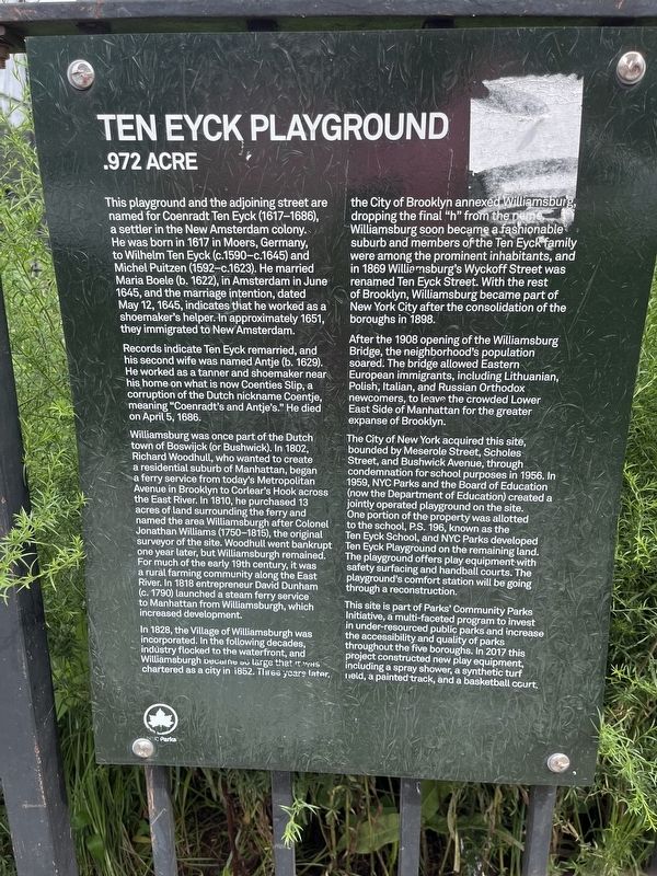
This playground and the adjoining street are named for Coenradt Ten Eyck (1617-1686), a settler in the New Amsterdam colony. He was born in 1617 in Moers, Germany, to Wilhelm Ten Eyck (c. 1590-c. 1645) and Michel Puitzen (1592-c. 1623). He married Maria Boele (b. 1622), in Amesterdam in June 1645, and the marriage, intention, dated May 12, 1645, indicates that he worked at he worked as a shoemaker's helper. In approximately 1651, they immigrated to New Amsterdam.
Records indicate Ten Eyck remarried, and his second wife was named Antje (b. 1629). He worked as a tanner and shoemaker near his home on what is now Coenties Slip, a corruption of the Dutch nickname Coentje meaning "Coenradt's and Antje's." He died on April 5, 1686.
Williamsburg was once part of the Dutch town of Boswijck (or Bushwick). In 1802, Richard Woodhull, who wanted to create a residential suburg of Manhattan, began a ferry service from today's Metropolitan Avenue in Brooklyn to Corlear's Hook across the East River. In 1810, he purchased 13 acres of land surrounding the ferry and named the area Williamsburg after Colonel Jonathan Williams (1750-1815),
this page online
In 1828, the Village of Williamsburgh was incorporated. In the following decades, industry flocked to the waterfront, and Williamsburgh became so large that it was chartered as a city in 1852. Three years later, the City of Brooklyn annexed Williamsburg, dropping the final "h" from the name. Williamsburg soon became a fashionable suburb and members of the Ten Eyck family were among the prominent inhabitants, and in 1869 Williamsburg's Wyckoff Street was renamed Ten Eyck Street. With the rest of Brooklyn, Williamsburg became part of New York City after the consolidation of the boroughs in 1898.
After the 1908 opening of the Williamsburg Bridge, the neighborhood's population soared. The bridge allowed Eastern European immigrants, including Lithuanian, Polish, Italian, and Russian Orthodox newcomers, to leave

The City of New York acquired this site, bounded by Meserole Street, Scholes Street, and Bushwick Avenue, through condemnation for school purposes in 1956. In 1959, NYC Parks and the Board of Education (now the Department of Education) created a jointly operated playground on the site. One portion of the property was allotted to the school, P.S. 196, known as the Ten Eyck School, and NYC Parks developed Ten Eyck Playground on the remaining land. The playground offers play equipment with safety surfacing and handball courts. The playground's comfort station will be going through a reconstruction.
This site is part of Parks' Community Parks Initiative, a multi-faceted program to invest in under-resourced public parks and increase the accessibility and quality of parks throughout the five boroughs. In 2017 this project constructed new play equipment, including a spray shower, a synthetic turf field, a painted track, and a basketball court.
Erected by NYC Parks.
Topics and series. This historical marker is listed in these topic lists: Colonial Era • Industry & Commerce • Parks & Recreational Areas • Settlements & Settlers. In addition, it is included in the NYC Parks series list. A significant historical date for this entry is April 5, 1686.
Location. 40° 42.517′ N, 73° 56.309′ W. Marker is in Brooklyn, New York, in Kings County. It is in East Williamsburg. It is on Meserole Street east of Bushwick Place, on the right when traveling west. Touch for map. Marker is at or near this postal address: 249 Meserole St, Brooklyn NY 11206, United States of America. Touch for directions.

Regionally, this marker is in New York City and on Long Island. It is also in the American Northeast, in the Mid-Atlantic, and on the Eastern Seaboard. Globally, it is in the North Atlantic Region, North America, the Western Hemisphere, the Western World, and the Anglosphere. Historically, it finds itself in what was once New Netherland and also one of the original Thirteen Colonies.
Other nearby markers. At least 8 other markers are within walking distance of this marker: Elizabeth Marrero Garden (approx. 0.6 miles away); Mary Alice Richardson & Geraldine Miller Community Room (approx. 0.6 miles away); Jan Peterson & Mildred Tudy Johnston (approx. 0.6 miles away); Theresa 'Tish' & Guido Cianciotta (approx. 0.6 miles away); Marie Leanza & Tillie Tarantino (approx. 0.6 miles away); Margaret Carnegie & Mildred Johnson (approx. 0.6 miles away); Taurean Spears Basketball Courts (approx. 0.7 miles away); a different marker also named Taurean Spears Basketball Courts (approx. 0.7 miles away). Touch for a list and map of all markers in Brooklyn.
Credits. This page was last revised on August 13, 2024. It was originally submitted on August 13, 2024, by Devry Becker Jones of Washington, District of Columbia. This page has been viewed 172 times since then and 20 times this year. Photos: 1, 2. submitted on August 13, 2024, by Devry Becker Jones of Washington, District of Columbia.
