Near Winchester in Frederick County, Virginia — The American South (Mid-Atlantic)
Lt. Collier’s Earthworks
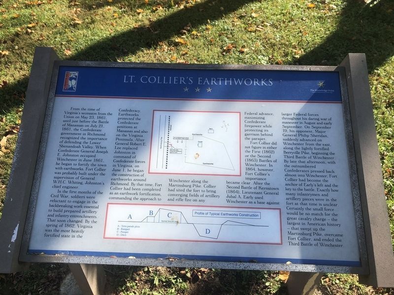
From the time of Virginia’s secession from the Union on May 23, 1861, until just before the Battle of Manassas on July 21, 1861, the Confederate government in Richmond recognized the importance of defending the Lower Shenandoah Valley. When Confederate General Joseph E. Johnston occupied Winchester in June, 1861, he began to fortify the town with earthworks. Fort Collier was probably built under the supervision of General W.H.C. Whiting, Johnston’s chief engineer.
In the first months of the Civil War, soldiers were reluctant to engage in the backbreaking work essential to build prepared artillery and infantry entrenchments. That soon changed. By the spring of 1862, Virginia was the most heavily fortified state in the Confederacy. Earthworks protected the Confederate positions at Manassas and also along the Virginia Peninsula. After General Robert E. Lee replaced Johnston in command of Confederate forces in Virginia, on June 1, he began the construction of earthworks around Richmond. By that time, Fort Collier had been completed as an earthwork fortification, commanding the approach to Winchester along the Martinsburg Pike.
this page online
Fort Collier did not figure in either the First (1862) or the Second (1863) Battles of Winchester. In 1864, however, Fort Collier’s importance became clear. After the Second Battle of Kernstown (1864), Lieutenant General Jubal A. Early used Winchester as a base against larger Federal forces throughout his daring war of maneuver in August and early September. On September 19, his opponent, Major General Philip Sheridan, suddenly advanced on Winchester from the east, along the lightly fortified Berryville Pike, beginning the Third Battle of Winchester. By late that afternoon, with the outnumbered Confederates pressed back almost into Winchester, Fort Collier had become the anchor of Early’s left and the key to the battle. Exactly how many infantrymen and artillery pieces were in the fort at the time is unclear. Certainly the small force would be no match for the great cavalry charge—the largest in American history—that swept up the Martinsburg Pike,
Photographed by Craig Swain, August 25, 2007
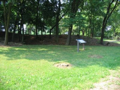
2. Portion of the Artillery Position of the Fort's West Side
The marker stands just to the side of the preserved earthworks.
Erected by Shenandoah at War / The Knowledge Point.
Topics. This historical marker is listed in these topic lists: Forts and Castles • War, US Civil. A significant historical month for this entry is May 1968.
Location. 39° 12.117′ N, 78° 9.241′ W. Marker is near Winchester, Virginia, in Frederick County. It can be reached from the intersection of Martinsburg Pike (U.S. 11) and Brooke Road (County Route 1322), on the right when traveling north. Located on the north side of the walking loop around Fort Collier, in the Fort Collier Civil War Center. Touch for map. Marker is at or near this postal address: 922 Martinsburg Pike, Winchester VA 22601, United States of America. Touch for directions.

Regionally, this marker is in the Shenandoah Valley. It is also in the American South, specifically in the Upper South, and in the Mid-Atlantic. Globally, it is in North America, the Western Hemisphere, the Western World, and the Anglosphere. Historically, it finds itself in what was once the territory of the Mississippian Culture, one of the original Thirteen Colonies,
Photographed by Craig Swain, August 25, 2007
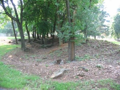
3. The Earthworks in Profile
To compare to the diagram, the ditch is directly in the center, with the parapet rising on the right. In front of the ditch (on the left of this photo) is a glacis slope. The glacis here is worn down somewhat, but served to re-direct enemy artillery projectiles, up and over the fortification.
Other nearby markers. At least 8 other markers are within walking distance of this marker: Fort Collier Stine House (within shouting distance of this marker); The Most Reliable Information (within shouting distance of this marker); a different marker also named Fort Collier (within shouting distance of this marker); a different marker also named Fort Collier (within shouting distance of this marker); The Cavalry Charge at Fort Collier (within shouting distance of this marker); a different marker also named Fort Collier (about 300 feet away, measured in a direct line); George Washington in Winchester (about 300 feet away); Third Battle of Winchester (about 400 feet away). Touch for a list and map of all markers in Winchester.
Another marker is no longer nearby. Fort Collier (was within shouting distance of this marker but has been replaced with another marker now near it).
More about this marker. Drawings on the marker detail the layout of the fort and the profile of the earthworks.
Regarding Lt. Collier’s Earthworks. The related markers section links the Civil War Trails marker and the four interpretive markers located at the Fort Collier Civil War Center.
Related markers. Click here for a list of markers that are related to this marker. To better understand the relationship, study each marker in the order shown.
Also see . . . Fort Collier Civil War Center. Website homepage (Submitted on September 13, 2007, by Craig Swain of Leesburg, Virginia.)
Credits. This page was last revised on January 6, 2025. It was originally submitted on September 13, 2007, by Craig Swain of Leesburg, Virginia. This page has been viewed 2,055 times since then and 37 times this year. Last updated on August 18, 2024, by Carl Gordon Moore Jr. of North East, Maryland. Photos: 1. submitted on November 7, 2020, by Devry Becker Jones of Washington, District of Columbia. 2, 3. submitted on September 13, 2007, by Craig Swain of Leesburg, Virginia. • Bernard Fisher was the editor who published this page.
