Memphis in Shelby County, Tennessee — The American South (East South Central)
St. Francis River/Hardin Cutoff/Whitehall Crevasse
Mississippi River Walk
Photographed by Jason Voigt, August 2, 2024
1. St. Francis River/Hardin Cutoff/Whitehall Crevasse Marker
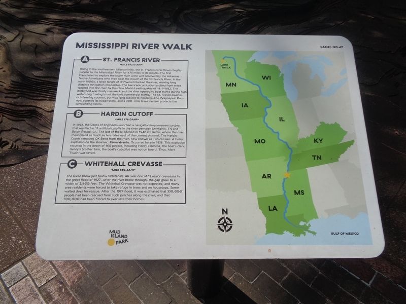
A) St. Francis River
Mile 672.0 AHP
Rising in the southeastern Missouri hills, the St. Francis River flows roughly parallel to the Mississippi River for 475 miles to its mouth. The first Frenchmen to explore the lower river were well received by the Arkansas Native Americans who lived near the mouth of the St. Francis River. In the early 1800s, a large tangle of driftwood blocked the river, making long distance navigation impossible. The barricade probably resulted from trees toppled into the river by the New Madrid earthquakes of 1811-1812. The driftwood was finally removed, and the river opened to boat traffic during high water. Log towing is not the only commercial traffic. The St. Francis basin is rich farming country, but was long subject to flooding. The Wappapelo Dam now controls its headwaters, and a 300-mile levee system protects the surrounding farms.
B) Hardin Cutoff
Mile 678.0 AHP
In 1933, the Corps of Engineers launched a navigation improvement project that resulted in 13 artificial cutoffs in the river between Memphis, TN and Baton Rouge, LA. The last of these opened in 1942 at Hardin, where the
this page online
C) Whitehall Crevasse
Mile 680.4 AHP
The levee break just below Whitehall, AR was one of 13 major crevasses in the great flood of 1927. After the river broke through, the gap grew to a width of 2,400 feet. The Whitehall Crevasse was not expected, and many area residents were forced to take refuge in trees and on housetops. Some waited days for rescue. After the 1927 flood, it was estimated that 330,000 people had been rescued from such perches along the river, and that 700,000 had been forced to evacuate their homes.
Erected by Mud Island Park. (Marker Number 47.)
Topics. This historical marker is listed in these topic lists: Disasters • Indigenous Peoples and Communities • Waterways & Vessels. A significant historical year for this entry is 1933.
Location. 35° 8.928′ N,
Photographed by Jason Voigt, August 2, 2024
2. St. Francis River/Hardin Cutoff/Whitehall Crevasse Marker

Regionally, this marker is in West Tennessee. It is also in the American South, specifically in the Deep South, in the Upper South, in the Mississippi Delta, and in the Great River Road Region. Globally, it is in North America, the Western Hemisphere, the Western World, and the Anglosphere. Historically, it finds itself in what was once the territory of the Mississippian Culture, one of the Confederate States of America, and the Antebellum South.
Other nearby markers. At least 8 other markers are within walking distance of this marker: Helena, Arkansas / Prairie Point (a few steps from this marker); Commerce, Mississippi/Buck Island No. 53/Norfolk Landing, Mississippi (a few steps from this marker); Horseshoe Cutoff/Friars Point, Mississippi/Yazoo Pass (a few steps from this marker); Island No. 63/Island No. 62/Old Town Bend (within shouting distance of this marker); Cow Islands No. 47 and No. 48/West Memphis, Arkansas/President's Island No. 45 (within shouting distance of this marker); Hopefield Point, Arkansas/Chicken Island/Redman Point (within shouting distance of this marker); Sunflower Cutoff/Jackson Cutoff (within shouting distance of this marker); Island No. 40 and No. 41/Centennial Cutoff/Chickasaw Bluff No. 3 (within shouting distance of this marker). Touch for a list and map of all markers in Memphis.
Credits. This page was last revised on August 30, 2024. It was originally submitted on August 30, 2024, by Jason Voigt of Glen Carbon, Illinois. This page has been viewed 237 times since then and 37 times this year. Photos: 1, 2. submitted on August 30, 2024, by Jason Voigt of Glen Carbon, Illinois.
