Big Delta in Southeast Fairbanks Census Area, Alaska — Northwest (North America)
Big Delta State Historical Park
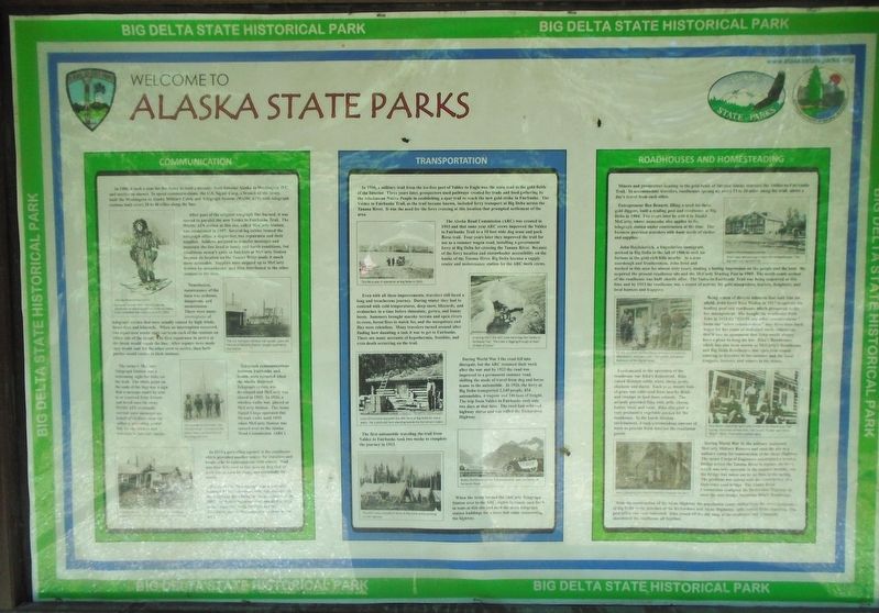
Welcome to Alaska State Parks
Photographed by William Fischer, Jr., August 16, 2024
1. Welcome to Alaska State Parks Marker
COMMUNICATION
In 1900, it took a year for the Army to send a message from Interior Alaska to Washington D.C. and receive an answer. To speed communications, the U.S. Signal Corp[s], a branch of the Army, built the Washington to Alaska Military Cable and Telegraph System (WAMCATS) with telegraph stations built every 20 to 40 miles along the line.
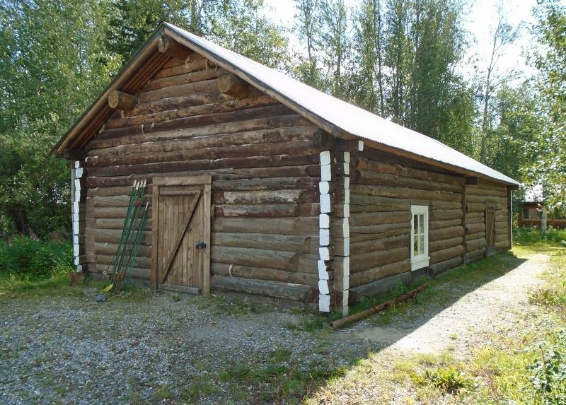
After part of the original telegraph line burned, it was moved to parallel the new Valdez to Fairbanks Trail. The WAMCATS station at this site, called McCarty Station, was established in 1907. Several log cabins housed the telegraph office, a dispatcher, two repairmen and their supplies. Soldiers assigned to transfer messages and maintain the line lived in lonely and harsh conditions, but conditions weren't quite as bad here at McCarty Station because its location on the Tanana River made it much more accessible. Supplies were shipped up to McCarty Station by sternwheeler, and then distributed to the other stations in the area.
Nonetheless, maintenance of the lines was arduous, dangerous, and monotonous. There were many interruptions of telegraph service that were usually
this page online
The Army's McCarty Telegraph Station was a welcoming sight for folks on the trail. The white paint on the ends of the logs was a sign that a message could be sent to or received from friends and loved ones far away. WAMCATS eventually carried more messages on behalf of civilians than the military, providing a vital out as the link for the settlers and travelers in Interior Alaska.
Telegraph communications between Fairbanks and Seattle were rerouted when the Alaska Railroad Telegraph system was developed and McCarty was closed in 1925. In 1926, wireless radio was placed at McCarty Station. The Army Signal Corps operated this 50-watt radio until 1935 when McCarty Station was turned over to the Alaska Road Commission (ARC).
In 1925 a post office opened in the roadhouse which provided another
Photographed by William Fischer, Jr., August 16, 2024
2. Welcome to Alaska State Parks Marker
For civilians, the telegraph was eventually replaced by the telephone, with maintenance of the telephone lines being the responsibility of the ARC. At first, telephones were installed only in some businesses along the lines and the businesses would relay messages to these in the area.
[Photo captions, top to bottom, read]
• Lieutenant William "Billy" Mitchell oversaw construction of the telegraph line in interior Alaska. Crews completed the project on June 27, 1903.
• The U.S. transport General J.W. Jacobs, pictured here at t[he] McCarty Station, b[r]ought supplies to the station.
• This quartet of old-timers, the "Grizzly Gang", cut many of the poles used in construction of the telegraph line.
• McCarty Station, [? - possibly "with its"] white log ends identifying it as a telegraph station, was a welcoming sight for travelers.
TRANSPORTATION
In 1900, a military trail from the ice-free port of Valdez to Eagle was the main trail to the gold fields of
Photographed by William Fischer, Jr., August 16, 2024
3. Former WAMCATS Station Building at Big Delta State Historical Park
The Alaska Road Commission (ARC) was created in 1905 and that same year ARC crews improved the Valdez to Fairbanks Trail to a 10 foot wide dog team and pack horse trail. Four years later they improved the trail for use as a summer wagon road, installing a government ferry at Big Delta for crossing the Tanana River. Because of the ferry location and sternwheeler accessibility on the banks of the Tanana River, Big Delta became a supply center and maintenance station for the ARC work crews.
Even with all these improvements, travelers still faced a long and treacherous journey. During winter they had to contend with cold temperatures, deep snow, blizzards, and avalanches in a time before thinsulate, gortex, and bunny boots. Summers
Photographed by William Fischer, Jr., August 16, 2024
4. Rika's Roadhouse at Big Delta State Historical Park
During World War I the road fell into disrepair, but the ARC resumed their work after the war and by 1922 the road was improved to a permanent summer road, shifting the mode of travel from dog and horse teams to the automobile. In 1926, the ferry at Big Delta transported 2,149 people, 854 automobiles, 4 wagons and 246 tons of freight. The trip from Valdez to Fairbanks took only two days at that time. The road had achieved highway status and was called the Richardson Highway.
The first automobile traveling the trail from Valdez to Fairbanks took two weeks to complete the journey in 1913.
When the Army turned the McCarty Telegraph Station over to the ARC, eighty to ninety men lived in tents at this site and used the army telegraph station buildings for a mess hall while maintaining the highway.
[Photo captions, top to bottom, read]
• The ferry was in operation at Big Delta in 1910.
• In spring 1917, the ARC crew hand digs the Valdez to Fairbanks Trail. The crew is digging through at least 25 feet of snow!
• Louis Grimsmore operated the ARC ferry at Big Delta for many years. He is pictured here standing beside the Ferryman's Cabin.
• Bobby Sheldon drove the first automobile over the Valdez to Fairbanks Road.
• The ARC crews camped in tents at Big Delta while working on the highway.
ROADHOUSES AND HOMESTEADING
Miners and prospectors heading to the gold fields of Interior Alaska traveled the Valdez-to-Fairbanks Trail. To accommodate travelers, roadhouses sprang up every 15 to 20 miles along the trail, about a day's travel from each other.
Entrepreneur Ben Bennett, filling a need for these gold diggers, built a trading post and road house at Big Delta in 1904. Two years later he sold it to Daniel McCarty, whose namesake also applies to the telegraph station under construction at the time. The business provided travelers with basic needs of shelter and supplies.
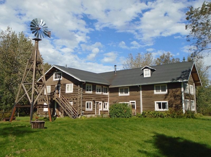
John Hajdukovich, a Yugoslavian immigrant, arrived in Big Delta in the fall of 1906 to seek his fortune in the gold-rich hills nearby. As a true sourdough and frontiersman, John lived and worked in this area for almost sixty years, making a lasting impression on the people and the land. He acquired the present roadhouse site and the McCarty Trading Post in 1909. The north-south section of the roadhouse was built shortly after. The Va[l]dez-to-Fairbanks Trail was being improved at this time and by 1913 the roadhouse was a center of activity for gold stampeders, traders, freighters, and local hunters and trappers.
Being a man of diverse interests that took him far afield, John hired Rika Wallen in 1917 to operate his trading post and roadhouse which prospered under her management. She bought the roadhouse from John in 1923 for "$10.00 and other considerations." Some say "other considerations" may have been back wages for her years of dedicated work; others say that it was an agreement that John would always have a place to hang his hat. Rika's Roadhouse, which has also been known as McCarty's Roadhouse and Big Delta Roadhouse, was open year-round catering to travelers in the summer and the local trappers, hunters, and miners in the winter.
Fundamental to the operation of the roadhouse was Rika’s homestead. Rika raised Holstein cattle, oxen, sheep, goats, chickens and ducks. Each year, twenty tons of grass was cultivated from nearby fields and swamps to feed these animals. The animals provided Rika with milk, cheese, butter, wool, and meat. Rika also grew a very productive vegetable garden for the roadhouse. In the harsh Alaskan environment, it took a tremendous amount of work to provide fresh food for the roadhouse guests.
During World War II, the military reclaimed McCarty Military Reserve and used the site as a military camp for construction of the Alcan Highway. The Army Corps of Engineers constructed a wooden bridge across the Tanana River to replace the ferry, which was only operable in the summer months, but the bridge was taken out by ice floes in the spring. The problem was solved with the construction of a high-truss steel bridge. The Alaska Road Commission realigned the Richardson Highway to meet the new bridge, bypassing Rika's Roadhouse.
With the construction of the Alcan Highway the population center shifted from the river community of Big Delta to the junction of the Richardson and Alcan Highways, aptly named Delta Junction. The post office was soon relocated. Rika closed off the old wing of the roadhouse and eventually abandoned the roadhouse all together.
[Photo captions, top to bottom, read]
• Rika's oxen are grazing in front of the Roadhouse. The big oxen was named Fritz
• On the porch of the Roadhouse are Louis Grimsmore, Rika Wallen, unknown cook, Ted Lowell, and James Rathbone of the Signal Corps.
• Rika Wallen (standing right) with friends at the Roadhouse, Ted Goring, Ferryman (seated left), Ted Lowell, Trucker and Henry "Butch" Stock, Prospector (seated right)
• Rika is standing with Marnie Washburn outside the Barn.
Erected by Alaska State Parks and Alaska Division of Parks and Outdoor Recreation.
Topics. This historical marker is listed in these topic lists: Communications • Industry & Commerce • Roads & Vehicles • Women. A significant historical year for this entry is 1900.
Location. 64° 9.283′ N, 145° 50.534′ W. Marker is in Big Delta in Southeast Fairbanks Census Area, Alaska. It can be reached from Richardson Highway. Marker is on the Big Delta State Historical Park grounds. Touch for map. Marker is at or near this postal address: 274.5 Richardson Highway (State Hwy 2), Delta Junction AK 99737, United States of America. Touch for directions.

Regionally, this marker is in the Athabascan Region and in Interior Alaska. It is also on the American Pacific Coast. Globally, it is in North America, on the Pacific Rim, in the Western Hemisphere, in the Western World, and in the Anglosphere. Historically, it finds itself in what was once the Russian Empire.
Other nearby markers. At least 8 other markers are within walking distance of this marker: Gold Rush Crossroads (a few steps from this marker); Domesticating the Wilderness (within shouting distance of this marker); Barn (within shouting distance of this marker); Homestead Outbuilding (within shouting distance of this marker); Spring House (within shouting distance of this marker); A Place to Rest (about 300 feet away, measured in a direct line); 30 Ft. Wooden River Boat (about 300 feet away); Roadhouse (about 300 feet away). Touch for a list and map of all markers in Big Delta.
Also see . . .
1. Big Delta State Historical Park. (Submitted on September 3, 2024, by William Fischer, Jr. of Reynoldsburg, Ohio.)
2. Big Delta State Historical Park. (Submitted on September 3, 2024, by William Fischer, Jr. of Reynoldsburg, Ohio.)
3. Erika "Rika" (Jakobson) Wallen at Find A Grave. (Submitted on September 3, 2024, by William Fischer, Jr. of Reynoldsburg, Ohio.)
Credits. This page was last revised on September 3, 2024. It was originally submitted on September 3, 2024, by William Fischer, Jr. of Reynoldsburg, Ohio. This page has been viewed 285 times since then and 38 times this year. Photos: 1, 2, 3, 4. submitted on September 3, 2024, by William Fischer, Jr. of Reynoldsburg, Ohio.
