Ballantyne in Charlotte in Mecklenburg County, North Carolina — The American South (South Atlantic)
Transportation
Photographed by Mark Parker, September 3, 2024
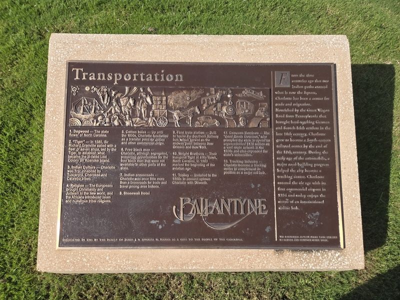
1. Transportation Marker
(Main panel with the key to the mural on the plaque and accompanying sculpture)
1. Dogwood - The state flower of North Carolina.
2. "Tiger" -In 1585, Sir Richard Grenville sailed with a fleet of seven ships, led by the Tiger, to establish what became the ill-fated Lost Colony of Roanoke Island.
3. Indian Culture - Charlotte was final inhabited by Tuscarora, Cherokee and Catawba tribes.
4. Religion - The Europeans brought Christianity and Judaism to the new world, and the Africans introduced Islam and numerous tribal religions.
5. Cotton bales - Up until the 1850s, Charlotte functioned as a transfer point for cotton and other commercial crops.
6. Free black man - Charlotte, although segregated, presented opportunities for the free black man that were not available in other parts of the state.
7. Indian crossroads - Charlotte was once little more than a crossroads for trade and travel among area Indians.
8. Stonewall Hotel
9. First train station - Built to house the Southern Railway hub, which served as the midway point between New Orleans and New York.
10. Wright Brothers - Their inaugural
this page online
11. Trolley - installed in the 1890s to connect uptown Charlotte with Dilworth.
12. Cameron Morrison - The "Good Roads Governor", who prompted the state to spend an unprecedented $128 million on a vast network in the 1920s and also expanded the state's universities.
13. Trucking Industry - Charlotte became a trucking center to complement its position as a major rail hub.
(right panel)
From the time centuries ago that two Indian paths crossed what is now the Square, Charlotte has been a center for trade and migration. Nourished by the Great Wagon Road from Pennsylvania that brought hard-working German and Scotch-Irish settlers in the the late 18th century, Charlotte grew to become a South-eastern railroad center by the end of the 19th century. During the early age of the automobile, a major road-building program helped the city become a trucking center. Charlotte entered the air age with its first commercial airport in 1934 and today enjoys the status of an international airline hub.
The monuments at Ballantyne were created by painter
Photographed by Mark Parker, September 3, 2024
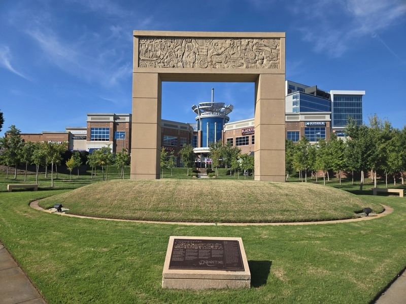
2. Transportation Marker and sculpture. Ballantyne Village is in the background
Erected 1995 by The family of James J. & Angela M. Harris.
Topics. This historical marker is listed in these topic lists: Air & Space • Indigenous Peoples and Communities • Railroads & Streetcars • Roads & Vehicles • Settlements & Settlers. A significant historical year for this entry is 1585.
Location. 35° 3.262′ N, 80° 51.038′ W. Marker is in Charlotte, North Carolina, in Mecklenburg County. It is in Ballantyne. It can be reached from the intersection of Johnston Road (U.S. 521) and Ballantyne Commons Parkway, on the right when traveling south. The marker is at ground level in front of the large arch. Parking is available nearby in the Ballantyne Village shopping complex. Touch for map. Marker is at or near this postal address: 14030 Johnston Rd, Charlotte NC 28277, United States of America. Touch for directions.

Regionally, this marker is in North Carolina’s Piedmont. It is also in the American South and specifically in the Upper South. Globally, it is in North America, the Western Hemisphere, the Western World, and the Anglosphere. Historically, it finds itself in

Photographed by Mark Parker, September 3, 2024
3. Closeup of Transportation sculpture
Other nearby markers. At least 8 other markers are within 3 miles of this marker, measured as the crow flies: Finance (within shouting distance of this marker); Technology (within shouting distance of this marker); Human Spirit (about 300 feet away, measured in a direct line); The Revolution in the Back Country / Sumpter's Camp at Clems Branch (approx. 1.9 miles away in South Carolina); The Revolution in the Backcountry / Sumter's Camp at Clems Branch (approx. 2.3 miles away in South Carolina); Trading Path (approx. 2.3 miles away); Polk Family Cemetery (approx. 2.4 miles away); President James K. Polk S.H.S. (approx. 2.4 miles away). Touch for a list and map of all markers in Charlotte.
Credits. This page was last revised on September 4, 2024. It was originally submitted on September 3, 2024, by Mark Parker of Hickory, North Carolina. This page has been viewed 272 times since then and 30 times this year. Photos: 1, 2, 3. submitted on September 3, 2024, by Mark Parker of Hickory, North Carolina. • Bernard Fisher was the editor who published this page.
