Chaptico in St. Mary's County, Maryland — The American Northeast (Mid-Atlantic)
Prosperous Port Town
Raided by British, July 1814
Photographed by Allen C. Browne, January 5, 2013
1. Prosperous Port Town Marker
Inscription.
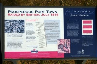
Prosperous Port Town. Raided by British, July 1814. , Colonial Settlement followed the rivers inland, and harbors with deep water became commercial and social centers. The Maryland colony was founded in 1634, and Chaptico was officially established by 1683. In 1689, Chaptico's John Coode organized a rebellion against Lord Baltimore's government in St. Mary's City. Thereafter, the Anglican Church of England was the official church of Maryland, and the state capital was moved to Annapolis. , Conflicting Portrayals of the War of 18 12 , 125 years later, the British feigned and advance up the Potomac River to disguise their advance on Washington, D.C. As they sailed up the Potomac, sailors came ashore to plunder plantations and destroy property, terrorizing the citizens of this young nation. , On July 30, 1814, the British landed at Chaptico's wharf and marched to Christ Church. Two different versions are told of their visit. , American Account , ...[The British] conduct would have disgraced cannibals; the houses were torn to pieces, the well which afforded water for the inhabitants was filled up. --- What was still worse, the Church and the Ashes of the Dead shared and equally bad or worse fate. Will you believe that the sunken graves were converted in to barbecue (sic) holes; the remaining glass in the church windows broken, the communion table was used as a dinner table, and then broken to pieces... [and a] vault was entered and the remains of the dead disturbed. Yes, my friend, the winding sheet was torn from the body of a lady of the first respectability . and the whole contents of the vault entirely deranged!... Cockburn was the head of it; that they destroyed the organs, that Judge Key's lady, who had been put into the vault, was ... wantonly exposed; and that his men were exasperated to desperation by this conduct. -- Replica of report from Robert Wright for the Daily National Intelligencer August 4, 1814. , British Accounts , "...we marched and took quiet possession of [Chaptico] without opposition. I remain all day quietly in Chaptico whist the boats shipped off tobacco which was found there in considerable quantity, and at night reembarked without molestation. I visited many house[s] in different parts of the country we passed through, the owners of which were living quietly with their families and seeming to consider themselves and the whole neighborhood as being entirely at my disposal. I caused no further inconvenience to [them], than obliging them to furnish supplies of cattle and stock for... forces under my orders." -- Rear Admiral Sir George Cockburn to Vice Admiral Sir Alexander Cochrane, July 31, 1814. , "... took possession of Chaptico -- where some ladies who had heard of our good behavior [sic] at Leonards Town remained -- and sang an[d] played the piano. We took from thence 70 Hhds [hogsheads] of tobacco, some flour, and military stores but preserved their houses [and] purchased from them stock and various articles of provisions. The men all fled, but the Ladies remained to see the wonderful Admrl. Cockburn and the British folks." -- Captain Robert Rowley report to his superiors, August, 1814. , Christ Church , King and Queen Episcopal Parish was organized in 1692,and the church built in 1736. It is a good example of the Georgian architectural style, inspired by the work of Sir Christopher Wren. Plan books showing the features of Wrens buildings were available in England, and this style flourished in Maryland throughout the 18th century. , The symmetry of the arched windows, and the elaborate cornice detailing (where the exterior walls meet the roof) are typical of the Georgian style. Christ Church is detailed with the Flemish bond brick pattern ,which is typical of early St. Mary's county buildings. , This church was built with taxes collected from all citizens Anglican or not, by Maryland's Provincial government.
Colonial Settlement followed the rivers inland, and harbors with deep water became commercial and social centers. The Maryland colony was founded in 1634, and Chaptico was officially established by 1683. In 1689, Chaptico's John Coode organized a rebellion against Lord Baltimore's government in St. Mary's City. Thereafter, the Anglican Church of England was the official church of Maryland, and the state capital was moved to Annapolis.
Conflicting Portrayals of the War of 1812
125 years later, the British feigned and advance up the Potomac River to disguise their advance on Washington, D.C. As they sailed up the Potomac, sailors came ashore to plunder plantations and destroy property, terrorizing the citizens of this young nation.
On July 30, 1814, the British landed at Chaptico's wharf and marched to Christ Church.
Two different versions are told of their visit.
American Account
...[The British] conduct would have disgraced cannibals; the houses were torn to pieces, the well which afforded water for the inhabitants was filled up. --- What was still worse, the Church & the Ashes of the Dead shared and
Click or scan to see this page online
equally bad or worse fate. Will you believe that the sunken graves were converted in to barbecue (sic) holes; the remaining glass in the church windows broken, the communion table was used as a dinner table, and then broken to pieces... [and a] vault was entered and the remains of the dead disturbed. Yes, my friend, the winding sheet was torn from the body of a lady of the first respectability . and the whole contents of the vault entirely deranged!... Cockburn was the head of it; that they destroyed the organs, that Judge Key's lady, who had been put into the vault, was ... wantonly exposed; and that his men were exasperated to desperation by this conduct. -- Replica of report from Robert Wright for the Daily National Intelligencer August 4, 1814.
British Accounts
"...we marched and took quiet possession of [Chaptico] without opposition. I remain all day quietly in Chaptico whist the boats shipped off tobacco which was found there in considerable quantity, and at night reembarked without molestation. I visited many house[s] in different parts of the country we passed through, the owners of which were living quietly with their
Photographed by Allen C. Browne, January 5, 2013
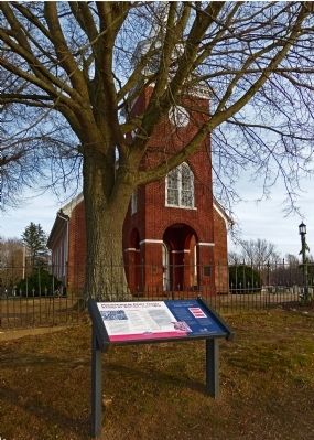
2. Prosperous Port Town Marker
families and seeming to consider themselves and the whole neighborhood as being entirely at my disposal. I caused no further inconvenience to [them], than obliging them to furnish supplies of cattle and stock for... forces under my orders." -- Rear Admiral Sir George Cockburn to Vice Admiral Sir Alexander Cochrane, July 31, 1814.
"... took possession of Chaptico -- where some ladies who had heard of our good behavior [sic] at Leonards Town remained -- and sang an[d] played the piano. We took from thence 70 Hhds [hogsheads] of tobacco, some flour, & military stores but preserved their houses [and] purchased from them stock and various articles of provisions. The men all fled, but the Ladies remained to see the wonderful Admrl. Cockburn and the British folks." -- Captain Robert Rowley report to his superiors, August, 1814.
Christ Church
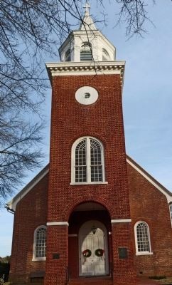
King and Queen Episcopal Parish was organized in 1692,and the church built in 1736. It is a good example of the Georgian architectural style, inspired by the work of Sir Christopher Wren. Plan books showing the features of Wrens buildings were available in England, and this style flourished
Photographed by Allen C. Browne, January 5, 2013
3. Flemish Bond
on the walls of Christ Church
in Maryland throughout the 18th century.
The symmetry of the arched windows, and the elaborate cornice detailing (where the exterior walls meet the roof) are typical of the Georgian style. Christ Church is detailed with the Flemish bond brick pattern ,which is typical of early St. Mary's county buildings.
This church was built with taxes collected from all citizens Anglican or not, by Maryland's Provincial government.
Location. 38° 21.963′ N, 76° 47.035′ W. Marker is in Chaptico, Maryland, in St. Mary's County. It can be reached from the intersection of Budd's Creek Road and Maddox Road. Marker is in front of Christ Church near the intersection of Maddox Road (MD 238) and Budd's Creek Road (MD 234). Touch for map. Marker is at or near this postal address: 25390 Maddox Rd, Chaptico MD 20621, United States of America. Touch for directions.
Regionally, this marker is in Southern Maryland. It is also in the American
Photographed by Allen C. Browne, January 5, 2013
4. Christ Church
South, specifically in the Upper South, in the Mid-Atlantic, in the Tidewater, in the Chesapeake Bay Region, and on the Eastern Seaboard. Globally, it is in the North Atlantic Region, North America, the Western Hemisphere, the Western World, and the Anglosphere. Historically, it finds itself in what was once one of the original Thirteen Colonies and also the Antebellum South.
Another marker is no longer nearby. Chaptico (was about 600 feet away, measured in a direct line but has been replaced with another marker now near it).
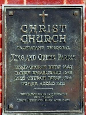
Christ Church Protestant Episcopal
King and Queen Parish
First Church Built 1642
Parish Established 1692
This Church built 1736
Tower Added 1913 ---
This Tablet given in memory of our parents Lewis Henry and Mary Love Davis, 1941
Maryland Inventory of Historical Properties website entry:
Links to National register of Historic Places Registration Form (Submitted on January 20, 2013, by Allen C. Browne of Silver Spring, Maryland.)
Photographed by Allen C. Browne, January 5, 2013
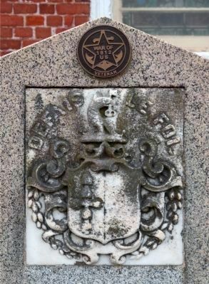
6. Defais Le Foi
The Key family tomb, allegedly desecrated by the British in 1814
Credits. This page was last revised on June 29, 2025. It was originally submitted on January 20, 2013, by Allen C. Browne of Silver Spring, Maryland. This page has been viewed 1,061 times since then and 34 times this year. Last updated on September 5, 2024, by James Martin Coode of Martinsburg, West Virginia. Photos:1, 2, 3, 4, 5, 6. submitted on January 20, 2013, by Allen C. Browne of Silver Spring, Maryland. • Devry Becker Jones was the editor who published this page.