
Capitol District in Richmond, Virginia — The American South (Mid-Atlantic)
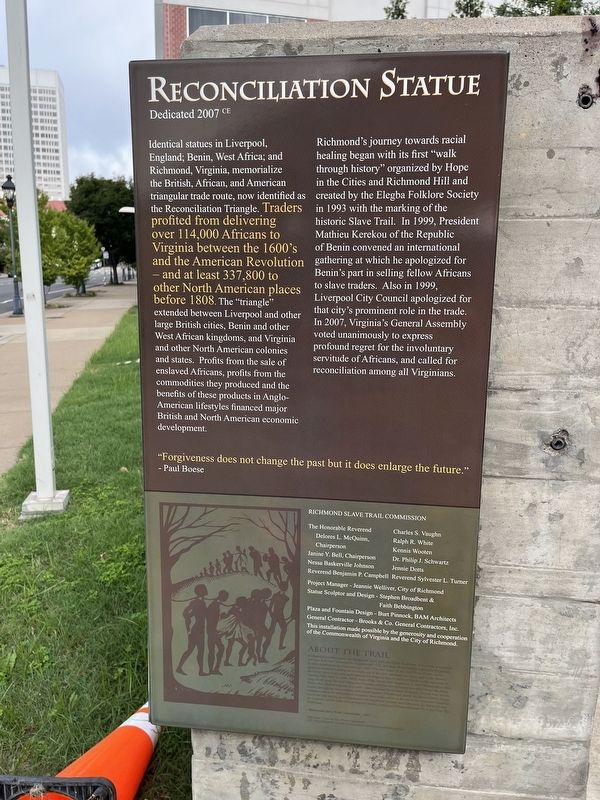
Reconciliation Statue
Dedicated 2007 CE
| — | Richmond Slave Trail | — |

Identical statues in Liverpool, England; Benin, West Africa; and Richmond, Virginia, memorialize the British, African, and American triangular trade route, now identified as the Reconciliation Triangle. Traders profited from delivering over 114,000 Africans to Virginia between the 1600’s and the American Revolution – and at least 337,800 to other North American places before 1808. The “triangle” extended between Liverpool and other large British cities, Benin and other West African kingdoms, and Virginia and other North American colonies and states. Profits from the sale of enslaved Africans, profits from the commodities they produced and the benefits of these products in Anglo-American lifestyles financed major British and North American economic development.
Richmond’s journey towards racial healing began with its first “walk through history” organized by Hope in the Cities and created by the Elegba Folklore Society in 1993 with the marking of the historic Slave Trail. In 1999, President Mathieu Kerek of the republic of Benin convened an international gathering at which he apologized for Benin’s part in selling fellow
this page online
"Forgiveness does not change the past but it does enlarge the future." - Paul Boese
Richmond Slave Trail Commission
The Honorable Reverend Delores L. McQuinn, Chairperson • Janine Y. Bell, Chairperson • Nessa Baskerville • Johnson • Reverend Benjamin P. Campbell • Charles S. Vaughan • Ralph R. White • Kennis Wooten • Dr. Philp J. Schwartz • Jennie Dotts • Reverend Sylvester L. Turner • Project Manager – Jeannie Welliver, City of Richmond • Statue Sculptor and Design – Stephen Broadbent & Faith Bebbington • Plaza and Fountain Design – Burt Pinnock, BAM Architects • General Contractor – Brooks & Co. General Contractors, Inc.
This installation made possible by the generosity and cooperation of the Commonwealth of Virginia and the City of Richmond.
About the Trail
Designed as a walking path, the Richmond Slave Trail chronicles the history
Title image: “After the Sale: Slaves Going South”, 1853, Painted from live by Eyre Crowe, courtesy the Chicago History Museum
Erected 2011

Topics. This historical marker is listed in these topic lists: African Americans • Colonial Era • Industry & Commerce • Peace. A significant historical year for this entry is 1808.
Location. 37° 32.086′ N, 77° 25.823′ W. Marker is in Richmond, Virginia. It is in the Capitol District. It is on East Main Street near North 15th Street, on the right when traveling west. Touch for map. Marker is at or near this postal address: 1486 E Main St, Richmond VA 23224, United States of America. Touch for directions.

Regionally, this marker is in Central Virginia. It is also in the American South and specifically in the Upper South. Globally, it is in the North Atlantic Region, North America, the Western Hemisphere, the Western World, and the Anglosphere. Historically, it finds itself in what was once the territory of the Mississippian Culture, one of the original Thirteen Colonies, one of the Confederate States of America, and the Antebellum South.
Other nearby markers. At least 8 other markers are within walking distance of this marker: The Triangle (a few steps from this marker); Odd Fellows Hall (within shouting distance of this marker); Bell Tavern (within shouting distance of this marker); Auction Houses (about 500 feet away); Kahal Kadosh Beth Shalome (about 600 feet away); The Old State Capitol (about 600 feet away); The General Assembly of Virginia (about 600 feet away); Winfree Cottage (about 700 feet away). Touch for a list and map of all markers in Richmond.
Other markers no longer nearby. Reconciliation Statue (has been replaced with this marker); Slave Trade Reconciliation Triangle (was here, next to this marker but has been reported to have been replaced with another marker now near it); a different marker also named Odd Fellows Hall (was within shouting distance of this marker but has been replaced with another marker now near it); Slave Auction Site (was within shouting distance of this marker but has been confirmed missing); Davenport Trading Company (was about 500 feet away, measured in a direct line but has been replaced with another marker now near it); The Slave Trade In Richmond (was about 700 feet away but has been reported to have been replaced with another marker now near it).
Related marker. Click here for another marker that is related to this marker. This marker has replaced the linked marker. There are slight differences in the inscriptions.
Credits. This page was last revised on September 7, 2024. It was originally submitted on September 7, 2024, by Devry Becker Jones of Washington, District of Columbia. This page has been viewed 273 times since then and 34 times this year. Photos: 1, 2, 3. submitted on September 7, 2024, by Devry Becker Jones of Washington, District of Columbia.
