Point Place in Lucas County, Ohio — The American Midwest (Great Lakes)
Cullen Park Best Management Practices
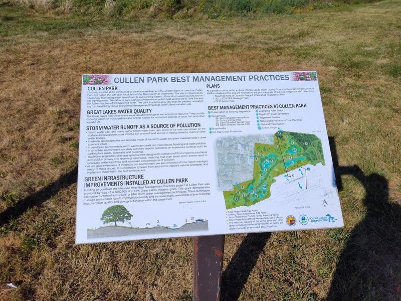
Photographed by Craig Doda, September 8, 2024
1. Cullen Park Best Management Practices Marker
Cullen Park
Uniquely located at the confluence of the Maumee River and the western basin of Lake Erie, Cullen Park sits within the 100 year floodplain of the Maumee River watershed. The site is influenced by seasonally fluctuating water levels from its surrounding waters, off site storm water sources and on site development. This 36-acre park is Ohio's western-most public boat access site to Lake Erie and the lower reaches of the Maumee River. The park functions as a very popular passive recreation site, bird watching venue and a Best Management Practices (BMP) demonstration site.
Great Lakes Water Quality
The Great Lakes nearshore areas are a valuable ecological and economic resource. They provide drinking water for municipalities and critical habitat for numerous species of birds, fish and other aquatic life.
Storm Water Runoff As A Source Of Pollution
• Storm water can take many paths. Storm water from rain, snow or ice melt can remain on the surface and evaporate, soak into the soil or runoff and end up in nearby streams, rivers or other water bodies.
• In natural landscapes the soil absorbs much of thestorm water and plant material holds it close to where it falls.
Click or scan to see
this page online
• In developed environments, storm water can create two major issues: flooding and water pollution.
• In an urban environment, our daily activities deposit pollutants on impervious surfaces such as parking lots, roads, sidewalks and buildings.
• Traditional engineered drainage systems were designed to collect runoff from impervious surfaces and quickly convey it to receiving waterways, meaning that even small storm events result in increased waterway flows and increased concentrations of pollution.
• As we gain awareness of threats to our environment, we are reminded of how nature manages many of these issues. It is imperative to learn from and mimic nature's natural processes and implement them within the built environment.
Green Infrastructure Improvements Installed At Cullen Park
Funding to construct the Maumee River Best Management Practices project at Cullen Park was provided by way of a $300,000 U.S. EPA Great Lakes Initiative grant. This grant demonstrates alternative "Green Infrastructure" or BMP storm water management techniques. These techniques manage

Photographed by Craig Doda, September 8, 2024
2. Cullen Park Best Management Practices Marker
Plans
As a project conducted in an Area of Great Lakes Water Quality Concern, the green infrastructure or BMPs installed at this site are intended to support the goals of the following plans and objectives:
• Maumee Area of Concern Stage 2 Watershed Restoration Plan
• 2011-2015 EPA Strategic Plan
• GLRI Action Plan
Best Management Practices At Cullen Park
1. Preservation of Existing VegetationMaumee River
2. Vernal Pools
2a. Semi-Shaded Vernal Pool
2b. Sunny Vernal Pool
2c. Semi-Shaded Vernal Pool
2d. Semi-Shaded Vernal Pool
3. Boardwalks
4. Rip Rap Outlet Protection
5 Vegetated Filter Strips
6. Rigid L.I.P. Level Spreaders
7 Vegetated Swales
8. Naturalized Prairie and Tree Plantings
9. Wetland Preservation
10. Gravel Verge
• Total Project Area: 9.21 Acres
• Existing Open Space Area: 8.09 Acres
• Storm Water from On-Site Paved Areas: 1.2 Acres
• Storm Water From Off-Site Residential Areas: 5.3 Acres
• The retention capacity of the vernal pools andother green infrastructure elements installed as part of this project exceeds an estimated 650,000 gallons.Photographed by Craig Doda, September 8, 20243. Cullen Park Best Management Practices Marker

Topics. This historical marker is listed in these topic lists: Horticulture & Forestry • Parks & Recreational Areas • Waterways & Vessels.
Location. 41° 42.256′ N, 83° 28.67′ W. Marker is in Point Place, Ohio, in Lucas County. It is at the intersection of 101st Street and North Summit Street, on the right when traveling west on 101st Street. Touch for map. Marker is at or near this postal address: 4530 N Summit St, Toledo OH 43611, United States of America. Touch for directions.

Regionally, this marker is on the Lake Erie Shore and in the Toledo Metropolitan Area. It is also in the American Midwest and in the Corn Belt. Globally, it is in North America, on the Great Lakes, in the Western Hemisphere, in the Western World, and in the Anglosphere. Historically, it finds itself in what was once the Viceroyalty of New France, the Haudenosaunee (Iroquois) Confederacy, the territory of the Mississippian Culture, and the Northwest Territory.
Other nearby markers. At least 8 other markers are within walking distance of this marker: Lucas County Civil War Veterans Memorial (approx. 0.4 miles away); Lucas County Vietnam Veterans Memorial (approx. 0.4 miles away); Lucas County WWII Veterans Memorial (approx. 0.4 miles away); Lucas County WWI Veterans Memorial (approx. 0.4 miles away); Lucas County Spanish American Veterans Memorial (approx. 0.4 miles away); Lucas County Iraq Veterans Memorial (approx. 0.4 miles away); Lucas County Korea Veterans Memorial (approx. 0.4 miles away); Lucas County Medal of Honor Recipients (approx. half a mile away).
Additional commentary.
1. About the marker
This plaque serves as a historical marker because it goes into detail about the historical context of environmental management practices.
— Submitted September 12, 2024, by Devry Becker Jones of Washington, District of Columbia.
Credits. This page was last revised on September 12, 2024. It was originally submitted on September 9, 2024, by Craig Doda of Napoleon, Ohio. This page has been viewed 168 times since then and 36 times this year. Photos: 1, 2, 3. submitted on September 9, 2024, by Craig Doda of Napoleon, Ohio. • Devry Becker Jones was the editor who published this page.
