Near Munhall in Allegheny County, Pennsylvania — The American Northeast (Mid-Atlantic)
Homestead Labyrinth
Photographed by Bradley Owen, September 3, 2024
1. Homestead Labyrinth Marker
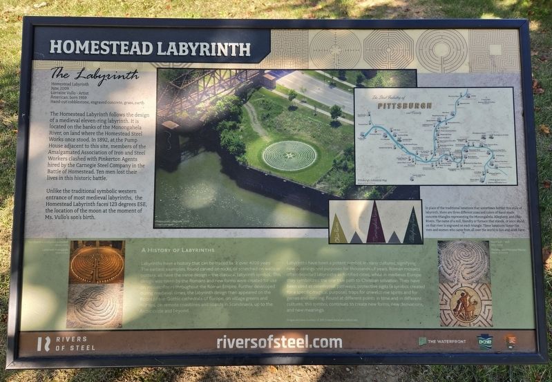
The Labyrinth
Homestead Labyrinth
June 2009
Lorraine Vullo - Artist
American: born 1959
Hand-cut cobblestone, engraved concrete, grass, earth
The Homestead Labyrinth follows the design of a medieval eleven-ring labyrinth. It is located on the banks of the Monongahela River, on land where the Homestead Steel Works once stood. In 1892, at the Pump House adjacent to this site, members of the Amalgamated Association of Iron and Steel Workers clashed with Pinkerton Agents hired by the Carnegie Steel Company in the Battle of Homestead. Ten men lost their lives in this historic battle.
Unlike the traditional symbolic western entrance of most medieval labyrinths, the Homestead Labyrinth faces 123 degrees ESE, the location of the moon at the moment of Ms. Vullo's son's birth.
A History of Labyrinths
Labyrinths have a history that can be traced back over 4000 years. The earliest examples, found carved on rocks, or scratched on walls or pottery, all have the same design - the classical labyrinth symbol. This design was taken by the Romans and new forms were created for use on mosaic floors throughout the Roman
this page online
Labyrinths have been a potent symbol in many cultures, signifying new meanings and purposes for thousands of years. Roman mosaics often depicted labyrinths as fortified cities, while in medieval Europe they symbolized the one true path to Christian salvation. They have been used as ceremonial pathways, protective sigils (a symbol created for a specific magical purpose), traps for unwelcome spirits and for games and dancing. Found at different points in time and in different cultures, this symbol continues to create new forms, new derivations, and new meanings.
Images and text courtesy of Jeff Seward www.labyrinthos.net
(Sidebar):
In place of the traditional lunations that sometimes border this style of labyrinth, there are three different sizes and colors of hand-made concrete triangles representing the Monongahela, Allegheny, and Ohio Rivers. The name of a mill, foundry or

Photographed by Bradley Owen, September 3, 2024
2. Homestead Labyrinth Marker
(Captions):
Homestead Labyrinth, 2009
Courtesy of Brian Kerr
Pittsburgh Industrial Map
Rivers of Steel Archives
The Chartres Cathedral Labyrinth
Chartres, France
Labyrinth Petroglyph
Pansaimol, Goa
Stone Labyrinth
Vaasa, Finland
Theseus and Minotaur Mosiac
Rhaetia, Switzerland
Erected by Rivers of Steel, Pennsylvania Department of Conservation and Natural Resources and National Park Service.
Topics. This historical marker is listed in these topic lists: Arts, Letters, Music • Industry & Commerce • Notable Events • Waterways & Vessels. A significant historical month for this entry is June 2009.
Location. 40° 24.852′ N, 79° 53.908′ W. Marker is near Munhall, Pennsylvania, in Allegheny County. It is on East Waterfront Drive 0.7 miles west of East 8th Avenue (Pennsylvania Route 837), on the right when traveling west. Marker is located near the trail access parking area for the Great Allegheny Passage at The Pump House. Touch for map.

Photographed by Bradley Owen, September 3, 2024
3. Homestead Labyrinth
Detail of the artwork is no longer nearly as defined as in the photo on the marker.

Regionally, this marker is in Greater Pittsburgh. It is also in the American Northeast, in the Mid-Atlantic, in the Ohio River Valley, in Appalachia, and specifically in Northern Appalachia. Globally, it is in North America, the Western Hemisphere, the Western World, and the Anglosphere. Historically, it finds itself in what was once the Viceroyalty of New France, the Haudenosaunee (Iroquois) Confederacy, and one of the original Thirteen Colonies.
Other nearby markers. At least 8 other markers are within walking distance of this marker: Labor Struggle (about 400 feet away, measured in a direct line); Yellow Dog (about 400 feet away); Blast Furnace Bells and Hopper (about 500 feet away); July 6, 1892 (about 500 feet away); The Battle of Homestead (about 600 feet away); Homestead Strike (about 600 feet away); Armor for America (about 600 feet away); Pump House (about 600 feet away). Touch for a list and map of all markers in Munhall.
Credits. This page was last revised on September 9, 2024. It was originally submitted on September 9, 2024, by Bradley Owen of Morgantown, West Virginia. This page has been viewed 478 times since then and 118 times this year. Photos: 1, 2, 3. submitted on September 9, 2024, by Bradley Owen of Morgantown, West Virginia.
