Shoreacres near La Porte in Harris County, Texas — The American South (West South Central)
Home of Mrs. Margaret McCormick

Photographed by James Hulse, May 21, 2024
1. Home of Mrs. Margaret McCormick Marker
Erected 1936 by State of Texas. (Marker Number 10727.)
Topics and series. This historical marker is listed in these topic lists: Immigration • Settlements & Settlers • War, Texas Independence • Women. In addition, it is included in the Texas 1936 Centennial Markers and Monuments series list. A significant historical date for this entry is April 21, 1836.
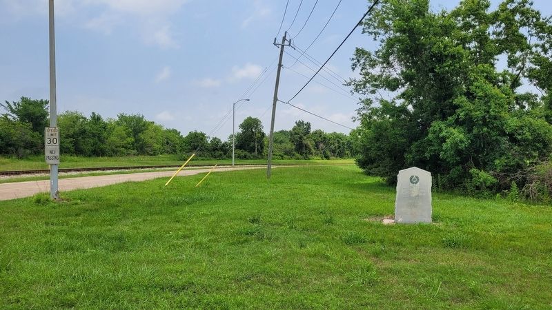
Location. 29° 43.397′ N, 95° 4.309′ W. Marker is near La Porte, Texas, in Harris County. It is in Shoreacres. It is at the intersection of Miller Cut Off Road and Power Plant Access Road, on the right when traveling west on Miller Cut Off Road. The marker is located along the access road to the old HL&P power plant (now gone). Touch for map. Marker is at or near this postal address: 2102 Miller Cut Off Rd, La Porte TX 77571, United States of America. Touch for directions.

Regionally, this marker is in the Houston Metropolitan Area. It is also in the American South and
this page online
Other nearby markers. At least 8 other markers are within 2 miles of this marker, measured as the crow flies: Mexican Cavalry, Battle of San Jacinto (approx. 1.1 miles away); The Texas Army Attacked in Four Divisions (approx. 1.2 miles away); Battle of San Jacinto (approx. 1.2 miles away); Site of Battle of San Jacinto, 1836 (approx. 1.2 miles away); Will You Come to the Bower, Battle of San Jacinto (approx. 1.2 miles away); Mexican Surrender (approx. 1.3 miles away); Almonte Captured (approx. 1.3 miles away); Within A Few Minutes, Battle of San Jacinto Site (approx. 1.6 miles away). Touch for a list and map of all markers in La Porte.
Also see . . . McCormick, Margaret (ca. 1788–1859). Texas State Historical Association (TSHA)
Margaret (Peggy) McCormick, early settler and cattlewoman, was born in Ireland around 1788 and moved(Submitted on May 28, 2024, by James Hulse of Medina, Texas.)to Texas with her husband, Arthur McCormick, and her two sons, Michael and John, in 1823–24. The family received a league of land on the south side of Buffalo Bayou at its junction with the San Jacinto River on August 10, 1824. They built a log cabin on the southwest shore of a small bay on the San Jacinto. Arthur drowned in late 1824. The widow and her young sons became cattle raisers and sold their stock to Louisiana buyers for the Opelousas market. In April 1836 the family was forced to flee across the river when Antonio López de Santa Anna's troops approached the San Jacinto. Their abandoned livestock was consumed by the Texas and Mexican armies. A few days after the battle of San Jacinto, Mrs. McCormick returned to find her home ransacked and her land strewn with the bodies of Mexican soldiers. She made her way three miles across the abandoned battlefield to Sam Houston's camp, where she demanded that he bury the dead. He refused, as did Santa Anna, so Peggy and her sons buried the corpses themselves. With the aid of one slave, Peggy became the owner of one of the largest cattle herds in Harris County between 1840 and 1850. Her herd grew from 200 to 400 head during the decade. Avaricious neighbors and county officials cheated the illiterate woman out of almost half of her league by ordering a resurvey that moved her eastern boundary onto the swampy San Jacinto shore, thereby producing unowned land on the west that was assigned to a veteran and then bought by George M. Patrick, the county surveyor. The family did not learn about the resurvey until after Peggy McCormick's death. Nor did the family know that, at an 1845 auction, the sheriff had sold 3,968 acres-all of her land except her fifty-acre homesite-to pay her debts. The land was bought by the county clerk. "Aunt Peggy," as she was called by the neighborhood, died in her home on July 30, 1859, when a fire consumed the building. Some believed the fire was set by thieves. Michael, the only living heir, discovered the boundary changes when he tried to settle the estate. He sued Patrick in 1869 but lost.Photographed by James Hulse, May 21, 20242. The marker is located along the access road to the old HL&P power plant (now gone)
Credits. This page was last revised on November 30, 2024. It was originally submitted on May 27, 2024, by James Hulse of Medina, Texas. This page has been viewed 1,232 times since then and 128 times this year. Last updated on September 17, 2024, by Jeff Leichsenring of Garland, Texas. Photos: 1, 2. submitted on May 28, 2024, by James Hulse of Medina, Texas.
