Lexington, Virginia — The American South (Mid-Atlantic)
What is a Gauge Dock?
Photographed by Bradley Owen, August 12, 2024
1. What is a Gauge Dock? Marker
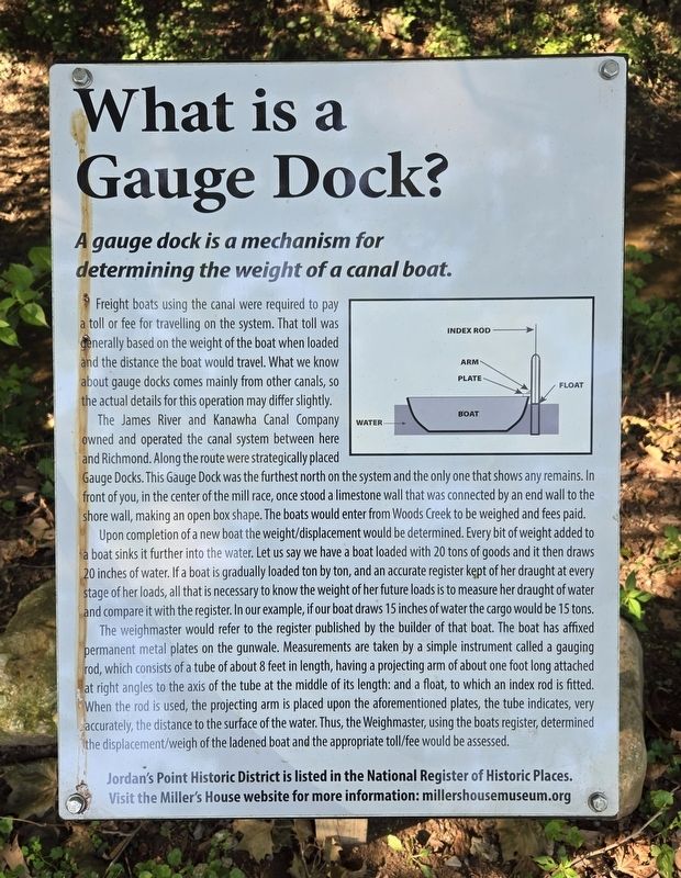
Freight boats using the canal were required to pay a toll or fee for travelling on the system. That toll was generally based on the weight of the boat when loaded and the distance the boat would travel. What we know about gauge docks comes mainly from other canals, so the actual details for this operation may differ slightly.
The James River and Kanawha Canal Company owned and operated the canal system between here and Richmond. Along the route were strategically placed Gauge Docks. This Gauge Dock was the furthest north on the system and the only one that shows any remains. In front of you, in the center of the mill race, once stood a limestone wall that was connected by an end wall to the shore wall, making an open box shape. The boats would enter from Woods Creek to be weighed and fees paid.
Upon completion of a new boat the weight/displacement would be determined. Every bit of weight added to a boat sinks it further into the water. Let us say we have a boat loaded with 20 tons of goods and it then draws 20 inches of water. If a boat is
this page online
The weighmaster would refer to the register published by the builder of that boat. The boat has affixed permanent metal plates on the gunwale. Measurements are taken by a simple instrument called a gauging rod, which consists of a tube of about 8 feet in length, having a projecting arm of about one foot long attached at right angles to the axis of the tube at the middle of its length: and a float, to which an index rod is fitted. When the rod is used, the projecting arm is placed upon the aforementioned plates, the tube indicates, very accurately, the distance to the surface of the water. Thus, the Weighmaster, using the boats register, determined the displacement/weigh of the ladened boat and the appropriate toll/fee would be assessed.
Visit the Miller's House website for more information: millershousemuseum.org
Erected 2017

Photographed by Bradley Owen, August 12, 2024
2. What is a Gauge Dock? Marker
Topics. This historical marker is listed in these topic lists: Industry & Commerce • Waterways & Vessels.
Location. 37° 47.534′ N, 79° 25.702′ W. Marker is in Lexington, Virginia. It can be reached from Moses Mill Road north of Jordan Point Road, on the right when traveling north. Marker is located in Jordan's Point Park. Touch for map. Marker is at or near this postal address: 834 Moses Mill Road, Lexington VA 24450, United States of America. Touch for directions.

Regionally, this marker is in Virginia’s Shenandoah Valley. It is also in the American South and specifically in the Upper South. Globally, it is in North America, the Western Hemisphere, the Western World, and the Anglosphere. Historically, it finds itself in what was once the territory of the Mississippian Culture, one of the original Thirteen Colonies, one of the Confederate States of America, and the Antebellum South.
Other nearby markers. At least 8 other markers are within walking distance of this marker: Batteaux, Freight Boats, Packet Boats, Wagons, Horses & Mules (a few steps from this marker); Gold Star Families Memorial Monument (within shouting distance of this marker); Fish Really Need a Ladder Sometimes! (within shouting distance of this marker); First it was cotton, then it was barrels, then it was grain... (within shouting distance of this marker); This is John Jordan's point. After all, he started it. (within shouting distance of this marker); Is a Packet Boat a Passenger Boat? (within shouting distance of this marker); Wharf, Work and Worship (within shouting distance of this marker); Entrepreneurs, Tradesmen and Laborers (about 300 feet away, measured in a direct line). Touch for a list and map of all markers in Lexington.
Regarding What is a Gauge Dock?. The website listed on this marker is incorrect. The website should be:
millershousemuseum.com
Credits. This page was last revised on September 29, 2024. It was originally submitted on September 25, 2024, by Bradley Owen of Morgantown, West Virginia. This page has been viewed 135 times since then and 18 times this year. Photos: 1, 2. submitted on September 25, 2024, by Bradley Owen of Morgantown, West Virginia.
