Near South Berwick in York County, Maine — The American Northeast (New England)
The Littlefield Homestead
Photographed by Steve Stoessel, October 13, 2024
1. The Littlefield Homestead Marker
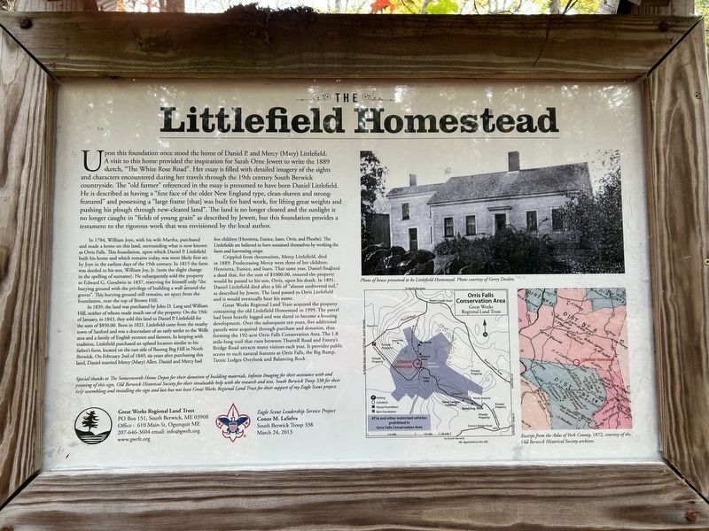
Upon this foundation once stood the home of Daniel P. and Mercy (Mary) Littlefield. A visit to this home provided the inspiration for Sarah Orne Jewett to write the 1889 sketch, "The White Rose Road". Her essay is filled with detailed imagery of the sights and characters encountered during her travels through the 19th century South Berwick countryside. The "old farmer" referenced in the essay is presumed to have been Daniel Littlefield. He is described as having a "fine face of the older New England type, clean-shaven and strong-featured and possessing a "large frame [that] was built for hard work, for lifting great weights and pushing his plough through new-cleared land". The land is no longer cleared and the sunlight is no longer caught in "fields of young grain" as described by Jewett, but this foundation provides a testament to the rigorous work that was envisioned by the local author.
In 1784, William Joye, with his wife Martha, purchased and made a home on this land, surrounding what is now known as Orris Falls. This foundation, upon which Daniel P. Littlefield built his home and which remains today, was most likely
this page online
In 1839, the land was purchased by John D. Lang and William Hill, neither of whom made much use of the property. On the 19th of January, in 1843, they sold this land to Daniel P. Littlefield for the sum of $850.00. Born in 1821, Littlefield came from the nearby town of Sanford and was a descendant of an early setter to the Wells area and a family of English yeomen and farmers. In keeping with tradition, Littlefield purchased an upland location similar to his father's farm, located on the cast side of Bauneg Beg Hill in North Berwick. On February 2nd of 1849, six years after purchasing this land, Daniel married Mercy (Mary) Allen. Daniel and Mercy had five children (Henrietta, Eunice, Isaro, Orris, and Phoebe).

Photographed by Steve Stoessel, October 13, 2024
2. The Littlefield Homestead Marker
Crippled from rheumatism, Mercy Littlefield, died in 1889. Predeceasing Mercy were three of her children: Henrietta, Eunice, and Isaro. That same year, Daniel finalized a deed that, for the sum of $1000.00, ensured the property would be passed to his son, Orris, upon his death. In 1891, Daniel Littlefield died after a life of "almost undiverted toil," as described by Jewett. The land passed to Orris Littlefield and it would eventually bear his name.
Great Works Regional Land Trust acquired the property containing the old Littlefield Homestead in 1999. The parcel had been heavily logged and was slated to become a housing development. Over the subsequent ten years, five additional parcels were acquired through purchase and donation, thus forming the 192-acre Orris Falls Conservation Area. The 1.8 mile-long trail that runs between Thurrell Road and Emery's Bridge Road attracts many visitors each year. It provides public access to such natural features as Orris Falls, the Big Bump, Tatnic Ledges Overlook and Balancing Rock.
Special thanks

Photographed by Steve Stoessel, October 13, 2024
3. A View of Some of the Foundation of the House
Photo of house presumed to be Littlefield Homestead. Photo courtesy of Gerry Desilets.
Excerpt from the Atlas of York County, 1872, courtesy of the Old Berwick Historical Society archives.
Erected 2013 by Great Works Regional Land Trust, Conor LaSelva, Eagle Scout South Berwick Troop 338.
Topics. This historical marker is listed in these topic lists: Agriculture • Parks & Recreational Areas • Settlements & Settlers. A significant historical year for this entry is 1784.
Location. 43° 16.565′ N, 70° 42.654′ W. Marker is near South Berwick, Maine, in York County. It can be reached from no nearby street. Marker is 0.6 mile from trailhead on Emery Road. Touch for map. Marker is in this post office area: South Berwick ME

Photographed by Steve Stoessel, October 13, 2024
4. Related Plaque on Another Section of the Remains

Regionally, this marker is in the American Northeast, in New England, and on the Eastern Seaboard. Globally, it is in the North Atlantic Region, North America, the Western Hemisphere, the Western World, and the Anglosphere.
Other nearby markers. At least 8 other markers are within 6 miles of this marker, measured as the crow flies: North Berwick Veterans Memorial (approx. 2.4 miles away); North Berwick State of Maine Veterans Memorial (approx. 2.4 miles away); Mount Hope Fire Tower (approx. 3.7 miles away); Ossipee Hill Fire Tower (approx. 3.7 miles away); The David N. Hilton Memorial (approx. 3.7 miles away); St. Aspinquid (approx. 3.8 miles away); Veterans from South Berwick, Maine (approx. 5.4 miles away); David von Schlegell (approx. 5.9 miles away).
Also see . . . Orris Falls Conservation Area. (Submitted on October 15, 2024, by Steve Stoessel of Niskayuna, New York.)
Credits. This page was last revised on February 17, 2026. It was originally submitted on October 15, 2024, by Steve Stoessel of Niskayuna, New York. This page has been viewed 697 times since then and 129 times this year. Photos: 1, 2, 3, 4. submitted on October 15, 2024, by Steve Stoessel of Niskayuna, New York.
