Near Richmond in Henrico County, Virginia — The American South (Mid-Atlantic)
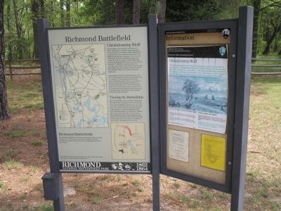
Chickahominy Bluff
Richmond Battlefield
| — | Richmond National Battlefield Park – 1862/1864 | — |
Photographed by Bill Coughlin, April 24, 2007
1. Chickahominy Bluff Marker
Unanticipated obstacles delayed Jackson, and late on the afternoon of June 26, 1862, Hill forced a crossing two miles upriver from here and captured Mechanicsville. Hill’s success allowed Lee to transfer the troops assembled here at Chickahominy Bluff over to the northern bank of the river. Shortly before sunset, fragments of the Confederate army launched attacks just east of Mechanicsville at the Battle of Beaver Dam Creek, two miles from here.
Touring the Battlefields
This is the first stop on an extensive driving tour that mirrors the movements of
this page online
Right Panel: Chickahominy Bluff
”No one had any theory about the delay of Jackson, which was a cause of great anxiety…. Suddenly the lookers on … began looking with interest, and then Genl. Lee himself … joined then… [He] continued his observation for a few minutes, and then descended to the road. Advancing to Genl. Longstreet, he said ‘Those are [A.P.] Hill’s men, and then, in as quiet a tone as if he spoke of the weather, he said, ‘General, you may now cross over.’” - Major Joseph Brent, CSA Magruder’s staff
Erected by Richmond National Battlefield Park - National Park Service.
Topics. This historical marker is listed in this topic list: War, US Civil. A significant historical date for this entry is June 26, 1862.
Location. This marker has been replaced by another marker nearby.
Photographed by Bill Coughlin, April 24, 2007
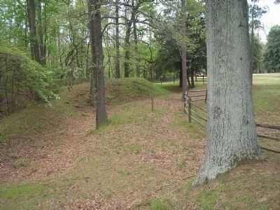
2. Confederate Fortifications at Chickahominy Bluff
Earthworks near the marker were used to view the Union Army approaching Richmond in June of 1862.

Regionally, this marker was in the Piedmont and in Central Virginia. It was also in the American South, specifically in the Upper South, and on the Eastern Seaboard. Globally, it was in the North Atlantic Region, North America, the Western Hemisphere, the Western World, and the Anglosphere. Historically, it found itself in what was once the territory of the Mississippian Culture, one of the original Thirteen Colonies, one of the Confederate States of America, and the Antebellum South.
Other nearby markers. At least 8 other markers are within 2 miles of this location, measured as the crow flies: A different marker also named Chickahominy Bluff (about 600 feet away, measured in a direct

Photographed by Bill Coughlin, April 24, 2007
3. Richmond National Battlefield Park
Marker is in the Chickahominy Bluff Unit of Richmond National Battlefield Park.
Other markers no longer nearby. The Seven Days Begin (was within shouting distance of this marker but has been replaced with another marker now near it); Richmond Defences (was approx. half a mile away but has been confirmed missing).
Related marker. Click here for another marker that is related to this marker. New Marker At This Location also titled "Chickahominy Bluff".
Also see . . .
1. Places To Go in Richmond National Battlefield Park. National Park Service website. (Submitted on January 2, 2009, by Bill Coughlin of Woodland Park, New Jersey.)
2. The Seven Days Battle. HistoryCentral.com website. (Submitted on January 2, 2009, by Bill Coughlin of Woodland Park, New Jersey.)
Photographed by Bill Coughlin, April 24, 2007
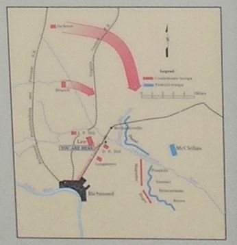
4. Chickahominy Bluff Battle Map from Marker
Lee wanted to maneuver to get beyond the right of the Union army, forcing the Federals away from Richmond.
Photographed by Bill Coughlin, April 24, 2007
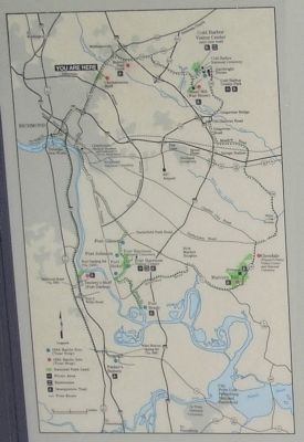
5. Richmond Battlefield
The national battlefield park contains sites relating to three separate events of the Civil War: the Seven Days Campaign of 1862, the Overland Campaign of 1864, and the late-war fighting north of the James River.
Credits. This page was last revised on October 16, 2024. It was originally submitted on January 2, 2009, by Bill Coughlin of Woodland Park, New Jersey. This page has been viewed 2,702 times since then and 57 times this year. Last updated on October 16, 2024, by Carl Gordon Moore Jr. of North East, Maryland. Photos: 1, 2, 3, 4, 5. submitted on January 2, 2009, by Bill Coughlin of Woodland Park, New Jersey. • Bernard Fisher was the editor who published this page.
