Near Keystone in Pennington County, South Dakota — The American Midwest (Upper Plains)
Island in the Plains
Photographed by Cosmos Mariner, August 18, 2023
1. Island in the Plains Marker
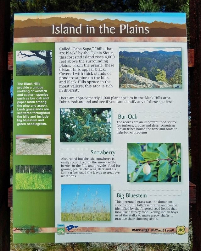
Called “Paha Sapa,” “hills that are black” by the Oglala Sioux, this forested island rises 4,000 feet above the surrounding plains. From the prairie, these distant hills appear black. Covered with thick stands of ponderosa pine on the hills, and Black Hills spruce in the moist valleys, this area is rich in diversity.
There are approximately 1,000 plant species in the Black Hills area. Take a look around and see if you can identify any of these species:
Bur Oak
The acorns are an important food source for turkeys, grouse and deer. American Indian tribes boiled the bark and roots to help bowel problems.
Snowberry
Also called buckbrush, snowberry is easily recognized by the snowy white berries in the fall, and provides food for grouse, prairie chickens, deer and elk. Some tribes used the leaves to treat eye irritations.
Big Bluestem
This perennial grass was the dominant species on the tallgrass prairie and can be identified by the fingered seed heads that look like a turkey foot. Young indian boys used the stalks to make arrow shafts to practice their shooting skills.
The Black Hills provide a unique melding of western and eastern
this page online
Erected by Forest Service, United States Department of Agriculture.
Topics. This historical marker is listed in these topic lists: Indigenous Peoples and Communities • Science & Medicine.
Location. 43° 50.461′ N, 103° 23.513′ W. Marker is near Keystone, South Dakota, in Pennington County. It is on Iron Mountain Road (U.S. 16A) half a mile west of North Playhouse Road (County Highway 359), on the right when traveling north. The marker is located in a pull-out on the north side of the road. Touch for map. Marker is in this post office area: Keystone SD 57751, United States of America. Touch for directions.

Regionally, this marker is in South Dakota’s West River, in the Badlands, and in Greater Rapid City. It is also in the American Black Hills, in the Lewis & Clark Corridor, on the prairies, and on the Northern Plains. Globally, it is in North America, the Western Hemisphere, the Western World,
Photographed by Cosmos Mariner, August 18, 2023
2. Island in the Plains Marker
Other nearby markers. At least 8 other markers are within 4 miles of this marker, measured as the crow flies: Peter Norbeck (approx. 2.4 miles away); The Father of Mount Rushmore (approx. 2.8 miles away); The Pigtail Bridges (approx. 2.9 miles away); Civilian Conservation Corps Camp (approx. 3 miles away); Gutzon Borglum (approx. 3.9 miles away); a different marker also named Gutzon Borglum (approx. 3.9 miles away); Significant Black Hills Native American Sites (approx. 3.9 miles away); Traditional Ecological Knowledge (approx. 3.9 miles away). Touch for a list and map of all markers in Keystone.
Also see . . . Black Hills (Wikipedia).
Excerpt: The Black Hills is an isolated mountain range rising from the Great Plains of North America in western South Dakota and extending into Wyoming, United States. The name of the range in Lakota is Pahá Sápa. American Indian tribes have a long history in the Black Hills and consider it a sacred site. After conquering the Cheyenne in 1776, the Lakota (Sioux) took the territory of the Black Hills, which became central to their culture.(Submitted on October 20, 2024, by Cosmos Mariner of Cape Canaveral, Florida.)
Credits. This page was last revised on October 20, 2024. It was originally submitted on October 20, 2024, by Cosmos Mariner of Cape Canaveral, Florida. This page has been viewed 235 times since then and 48 times this year. Photos: 1, 2. submitted on October 20, 2024, by Cosmos Mariner of Cape Canaveral, Florida.
