Boothbay Harbor in Lincoln County, Maine — The American Northeast (New England)
A Checkered Past
Boothbay Harbor, Maine
| — | The Museum in the Streets | — |

Photographed by Darren Jefferson Clay, October 14, 2024
1. A Checkered Past Marker
William Foster built the bridge house and wharf in 1902 after the town gave him a permit to connect it to the footbridge. The next year, selectman Cyrus Tupper investigated Foster, supposedly a fish dealer, and his use of the building. Tupper discovered Foster was using the bridge house as part of a bootlegging operation at a time when Maine was a dry state. Local legend has it that a considerable amount of illegal alcohol made its way into Boothbay Harbor through the trap door in the floor of the structure. Although many consider it to have been the bridgetender's building, only Foster actually tended the draw. Since about 1909 it has served a more seasonal role, first as a candy and ice cream shop, then as gift shops and arts and crafts studios under various owners.
William Foster construit le quai et la maison du pont en 1902 lorsque la ville lui donne l'autorisation de relier la maison à la passerelle L'année suivante, le conseiller municipal Cyrus Tupper mène une enquête sur Foster, qui se dit poissonnier, et sur son usage du bâtiment. Tupper découvre que Foster se livre à la contre- bande d'alcool, lors de la prohibition
this page online
Erected by The Museum in the Streets. (Marker Number 9.)
Topics. This historical marker is listed in these topic lists: Industry & Commerce • Law Enforcement • Notable Buildings • Waterways & Vessels.
Location. 43° 51.072′ N, 69° 37.532′ W. Marker is in Boothbay Harbor, Maine, in Lincoln County. It can be reached from Townsend Avenue east of Bridge Street, on the left when traveling south. Located midway across the Boothbay Harbor footbridge. Touch for map. Marker is in this post office area: Boothbay Harbor ME 04538, United States of America. Touch for directions.

Regionally, this marker is in Midcoast Maine. It is also

Photographed by Darren Jefferson Clay, October 14, 2024
2. A Checkered Past Marker
Other nearby markers. At least 8 other markers are within walking distance of this marker: Along the Waterfront in 1885 (within shouting distance of this marker); Bringing the Town Closer Together (about 400 feet away, measured in a direct line); Memorial Day Parade on the Bank Square (about 600 feet away); Up the Street and Down (about 700 feet away); An Enduring Tradition (about 700 feet away); A Nautical Heritage (about 700 feet away); A Lovely Spot for a Hotel (about 800 feet away); Preserving a Business Dynasty (about 800 feet away). Touch for a list and map of all markers in Boothbay Harbor.

Photographed by Darren Jefferson Clay, October 14, 2024
3. The Bridge House
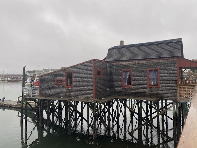
Photographed by Darren Jefferson Clay, October 14, 2024
4. The Bridge House

Photographed by Darren Jefferson Clay, October 14, 2024
5. The Bridge House
Credits. This page was last revised on October 29, 2024. It was originally submitted on October 20, 2024, by Darren Jefferson Clay of Duluth, Georgia. This page has been viewed 200 times since then and 45 times this year. Photos: 1, 2, 3, 4, 5. submitted on October 20, 2024, by Darren Jefferson Clay of Duluth, Georgia. • Michael Herrick was the editor who published this page.
