Folsom in Sacramento County, California — The American West (Pacific Coastal)
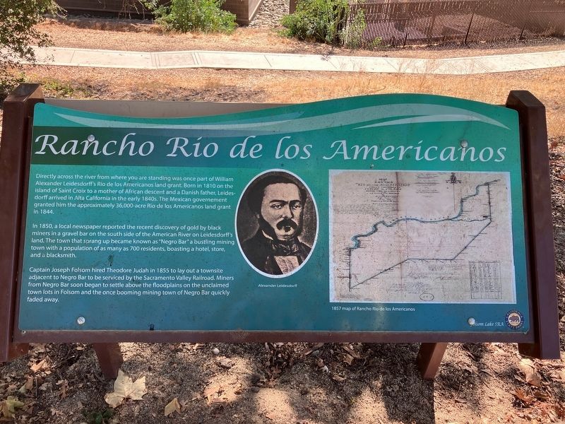
Rancho Rio de los Americanos
Photographed by Barry Swackhamer
1. Rancho Rio de los Americanos Marker
Captions: (oval) Alexander Leidesdorff; (map on right) 1857 map of Rancho Rio de los Americanos.
Directly across the river from where you are standing was once part of William Alexander Leidedorff's Rio de los Americanos land grant. Born in 181 0on the island of Saint Croix to a mother of African descent and a Danish father, Leidensdorff arrived in Alta California in the early 1840s. The Mexican government granted him the approximately 36,000-acre Rio de los Americanos land grant in 1844.
In 1850, a local newspaper reported the recent discovery of gold by black miners in a gravel bar on the south side of the American River on Leidesdorff's land. The town that sprang up became known as "Negro Bar" a bustling mining town with a population of as many as 700 residents, boasting a hotel, store and a blacksmith.
Captain Joseph Folsom hired Theodor Judah in 1855 to lay out a townsite adjacent to Negro Bar to be serviced by the Sacramento Valley Railroad. Miners from Negro Bar soon began to settle above the floodplains on the unclaimed town lots in Folsom and the once booming mining town of Negro Bar faded away.
Erected by California State Parks.
Topics. This historical marker is listed in these topic
this page online
Location. 38° 40.641′ N, 121° 11.43′ W. Marker is in Folsom, California, in Sacramento County. It can be reached from Black Miners Bar Road (aka Park Road) near Greenback Lane. The marker is located near the western most parking lot in Black Miners Bar, part of Folsom Lake State Recreation Area. Touch for map. Touch for directions.

Regionally, this marker is in California’s Sacramento Metro, in the Sacramento Valley, and specifically in the Central Valley. It is also on the American Pacific Coast. Globally, it is in North America, on the Ring of Fire, on the Pacific Rim, in the Western Hemisphere, in the Western World, and in the Anglosphere. Historically, it finds itself in what was once New Spain and also Mexico’s Alta California.
Other nearby markers. At least 8 other markers are within walking distance of this marker: Chinese Immigrants (here, next to this marker); The First Peoples (here, next to this marker); Black Miners (within shouting distance of this marker); a different marker also

Photographed by Barry Swackhamer
2. Rancho Rio de los Americanos Marker
The American River beyond
Also see . . . The California Mighty Oak Of The Leidesdorff Land Grant Dispute -- Kevin Knauss. The Stockton Independent newspaper put it best with an article about the Leidesdorff land grant titled The Grant Curse. A sizeable portion of Spanish and Mexican land grants in California seemed to be cursed with endless rounds of litigation to determine their authenticity and boundaries. The Leidesdorff Mexican land grant, Rancho Rio de los Americanos, was no different. The original map, delineating the boundaries of the Leidesdorff land grant of 1844, was finally sustained by the U. S. Supreme Court in 1864. Central to the survey of the land grant was an oak tree on the banks of the American River. (Submitted on October 26, 2024, by Barry Swackhamer of Brentwood, California.)
Credits. This page was last revised on October 29, 2024. It was originally submitted on October 26, 2024, by Barry Swackhamer of Brentwood, California. This page has been viewed 347 times since then and 88 times this year. Photos: 1, 2. submitted on October 26, 2024, by Barry Swackhamer of Brentwood, California.
