
The Loop District in Chicago in Cook County, Illinois — The American Midwest (Great Lakes)
Michigan Avenue Bridge and Wacker Drive Esplanade
Edward H. Bennett, architect; 1918-28
| — | Chicago Landmark | — |

Photographed by Sean P. Flynn, October 30, 2024
1. Michigan Avenue Bridge and Wacker Drive Esplanade Marker
Designated on October 2, 1991
Richard M. Daley, Mayor
Erected by Commission on Chicago Landmarks; City of Chicago.
Topics and series. This historical marker is listed in these topic lists: Arts, Letters, Music • Bridges & Viaducts • Roads & Vehicles • Waterways & Vessels. In addition, it is included in the Illinois, Chicago Landmarks Commission series list. A significant historical year for this entry is 1918.
Location. 41° 53.314′ N, 87° 37.486′ W. Marker is in Chicago, Illinois, in Cook County. It is in The Loop District. It is on East Wacker Drive west of North Michigan Avenue, on the right when traveling west. The marker is affixed to a wall overlooking the Chicago River, a short distance
this page online

Regionally, this marker is in the American Midwest. Globally, it is in North America, on the Great Lakes, in the Western Hemisphere, in the Western World, and in the Anglosphere. Historically, it finds itself in what was once the Viceroyalty of New France, the territory of the Mississippian Culture, and the Northwest Territory.
Other nearby markers. At least 8 other markers are within walking distance of this marker: Site of Fort Dearborn (a few steps from this marker); Rene Robert Cavalier Sieur de La Salle (a few steps from this marker); Fort Dearborn (a few steps from this marker); Chicago River (a few steps from this marker); The Bridges of Chicago (within shouting distance of this marker); Regeneration (within shouting distance of this marker); Old Fort Dearborn (within shouting distance of this marker); Kin Link, 2023 (within shouting distance of this marker). Touch for a list and map of all markers in Chicago.
More about this marker. The marker erroneously says that the

Photographed by Sean P. Flynn, October 30, 2024
2. Michigan Avenue Bridge and Wacker Drive Esplanade Marker
The southern end of the bridge, renamed the DuSable Bridge in 2010
Regarding Michigan Avenue Bridge and Wacker Drive Esplanade. Walker Drive is named for Charles Wacker, a businessman who ran the Chicago Planning Commission, overseeing implementation of the Burnham Plan, from 1909 until 1926.
The Michigan Avenue Bridge was renamed in 2010 in honor of Jean Baptiste Point DuSable, a man of Haitian descent who built his home on the north bank of the river around 1803 and is considered Chicago’s first permanent settler.
Also see . . .
1. Edward H. Bennett. From the Cultural Landscape Foundation, a brief bio of Edward H. Bennett.
Excerpt: "He moved to New York upon graduating and apprenticed under George B. Post until 1903, when he relocated to Chicago to work with architect and urban planner Daniel H. Burnham. It was with Burnham that Bennett gained acclaim, co-authoring the Plan for San Francisco in 1905 and the Plan of Chicago in 1909. Settled in Chicago, Bennett served on the Chicago Plan Commission and opened a private practice as an architect and city planner, partnering with(Submitted on October 31, 2024, by Sean P. Flynn of Oak Park, Illinois.)William E. Parsons and Harry T. Frost."Photographed by Sean P. Flynn, October 30, 20243. Michigan Avenue Bridge and Wacker Drive Esplanade MarkerThe marker overlooks the Chicago River, the Trump International Tower & Hotel to the left and the Wrigley Building to the right.

2. Chicago Architecture Center: 1909 Plan of Chicago. (Submitted on October 31, 2024, by Sean P. Flynn of Oak Park, Illinois.)

Photographed by Sean P. Flynn, November 18, 2023
4. DuSable Bridge
The bridge was known as Michigan Avenue Bridge until being renamed after Chicago's first permanent settler in 2010. The Wacker Drive Esplanade and this historical marker are at street level on the right.

Chicago Daily News Collection, Chicago History Museum, 1926
5. Wacker Drive opening, 1926
Crowds line Wacker Drive at its opening almost 100 years ago. The Wrigley Building and Tribune Tower can be seen in the background, across the river.
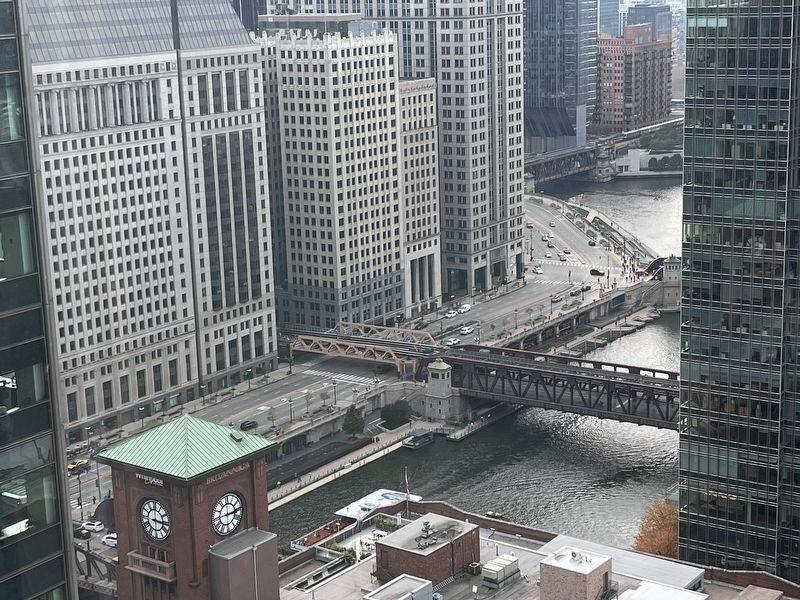
Photographed by Sean P. Flynn, October 30, 2024
6. Wacker Drive
This view shows Wacker Drive from across the Chicago River. Wacker is one of America’s more unique roadways, a double-decker street that runs parallel to the Chicago River. After passing the Wabash Avenue bridge (pictured), the road turns southward with the river towards the Eisenhower Expressway.
Credits. This page was last revised on November 7, 2024. It was originally submitted on October 31, 2024, by Sean P. Flynn of Oak Park, Illinois. This page has been viewed 426 times since then and 95 times this year. Photos: 1, 2, 3. submitted on October 31, 2024, by Sean P. Flynn of Oak Park, Illinois. 4. submitted on September 11, 2024, by Sean P. Flynn of Oak Park, Illinois. 5. submitted on October 31, 2024, by Sean P. Flynn of Oak Park, Illinois. 6. submitted on November 3, 2024, by Sean P. Flynn of Oak Park, Illinois.
