Downtown in Anchorage, Alaska — Northwest (North America)
Anchorage Area All-American City
Photographed by William Fischer, Jr., August 12, 2024
1. Anchorage Area All-American City Marker
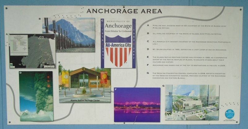
[Photo captions, clockwise from top left, read]
A. Pipeline map, showing most of AK (courtesy of the State of Alaska Joint Pipeline Office)
B. Oil pipeline (courtesy of the State of Alaska Joint Pipeline Office)
C. All-American City banner (courtesy of the Anchorage Downtown Partnership, Ltd.)
D. Mt. Spurr erupted in 1992, depositing a light layer of ash on Anchorage.
E. The Alaska Native Heritage Center was founded in 1999, as a cooperative effort by the Native [P]eoples of Alaska, to educate others about their culture and history.
F. Anchorage was named one of the top 10 destinations in the US. in 2005.
G. The Dena'ina Convention Center, completed in 2008. Artist's conception of the Dena'ina Convention Center, provided courtesy of the Anchorage Convention and Visitors Bureau.
Erected by 4th Avenue Market Place.
Topics. This historical marker is listed in these topic lists: Environment • Indigenous Peoples and Communities • Industry & Commerce • Settlements & Settlers. A significant historical year for this entry is 1992.
Location. 61° 13.123′ N, 149° 53.278′ W. Marker is in Anchorage, Alaska.
this page online

Regionally, this marker is in the Alaska Railroad Corridor, in the Athabascan Region, in the Prince William Sound, and in Southcentral Alaska. It is also on the American Pacific Coast. Globally, it is in North America, on the Ring of Fire, on the Pacific Rim, in the Western Hemisphere, in the Western World, and in the Anglosphere. Historically, it finds itself in what was once the Russian Empire.
Other nearby markers. At least 8 other markers are within walking distance of this marker: Anchorage Area 1950-1963 (a few steps from this marker); Bear Totem (a few steps from this marker); Anchorage Area 1940-1949 (within shouting distance of this marker); Anchorage Area Time Line (within shouting distance of this marker); a different marker also named Anchorage Area 1940-1949 (within shouting distance of this marker);
Photographed by William Fischer, Jr., August 12, 2024
2. Anchorage Area All-American City Marker
Credits. This page was last revised on November 5, 2024. It was originally submitted on November 5, 2024, by William Fischer, Jr. of Reynoldsburg, Ohio. This page has been viewed 217 times since then and 28 times this year. Photos: 1, 2. submitted on November 5, 2024, by William Fischer, Jr. of Reynoldsburg, Ohio.
