Thurmont in Frederick County, Maryland — The American Northeast (Mid-Atlantic)
A Creek Rediscovered
Catoctin Furnace Iron Trail
Photographed by Allen C. Browne, October 30, 2024
1. A Creek Rediscovered Marker
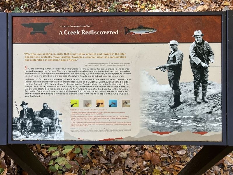
“We, who love angling, in order that it may enjoy practice and reward in the later generations, mutually move together towards a common goal—the conservation and restoration of American game fishes.”
— Creed of the Brotherhood of the Jungle Cock, adopted during the Angler's Campfire at Catoctin, April 13, 1940.
You are standing in front of Little Hunting Creek. For many years, this creek provided the energy needed to power the furnace. The water turned large wheels connected to bellows that pushed air into the stacks, heating the fire to temperatures exceeding 3,2700 Fahrenheit. the temperature needed to smelt iron ore. Smelting is the process of applying heat to ore to extract iron, the base metal.
In the early 20th century, the creek gained attention because of its native brook trout. United States Presidents Herbert Hoover, Franklin Delano Roosevelt, and Dwight D. Eisenhower all fished in Little Hunting Creek. In 1939, famous local fly fisherman Joe Brooks helped form the Brotherhood of the Jungle Cock, an organization that encourages fly fishermen to care for stream environments. Mr. Brooks was elected to the
this page online
[Captions:]
(Top) Brook trout are native to Little Hunting Creek.
» (Right) Joe Brooks and Frank Bentz, another prominent Maryland angler and conservationist, fishing together in the 1940s.
(Above) Fishermen use colorful and intricate flies to catch trout in Little Hunting Creek. Flies from left to right: Adams; Partridge and Orange; Woolly Bugger; Orange Stimulator; Starling and Purple.
« (Left) President Herbert Hoover fished on the property now known as Trout Run near the furnace lands. Here, he is pictured with his secretary, Lawrence Ritchie, after fishing at Ritchie's estate.
Erected by Catoctin Furnace Historical Society; William G. Pomeroy Foundation; Maryland Park Service; Maryland Department of Natural Resources.
Topics. This historical marker is listed in these topic lists: Fraternal or Sororal Organizations • Parks & Recreational Areas
Photographed by Allen C. Browne, October 30, 2024
2. A Creek Rediscovered Marker
Location. 39° 35.078′ N, 77° 26.166′ W. Marker is in Thurmont, Maryland, in Frederick County. It can be reached from Catoctin Mountain Highway, on the right when traveling south. Touch for map. Marker is at or near this postal address: 10182 Catoctin Mountain Hwy, Thurmont MD 21788, United States of America. Touch for directions.

Regionally, this marker is in the Washington Metropolitan Area and in Central Maryland. It is also in the American Mid-Atlantic. Globally, it is in North America, the Western Hemisphere, the Western World, and the Anglosphere. Historically, it finds itself in what was once one of the original Thirteen Colonies and also the Antebellum South.
Other nearby markers. At least 8 other markers are within walking distance of this marker: Destruction and Renewal (within shouting distance of this marker); A Fractured Landscape (within shouting distance of this marker); The Ingredients For Iron (within shouting distance of this marker); Walk Through History (about 400 feet away, measured in a direct line); Recreation For All (about 500 feet away); A Lost Pond (about 500 feet away); Waste Management (about 600 feet away); The Bridge that Moved (about 700 feet away). Touch for a list and map of all markers in Thurmont.
Other markers no longer nearby. Second Growth Forest (was a few steps from this marker but has been replaced with another marker now near it); Little Hunting Creek (was a few steps from this marker but has been replaced with another marker now near it); Slag Heaps (was about 600 feet away but has been replaced with another marker now near it).
Credits. This page was last revised on May 18, 2026. It was originally submitted on November 12, 2024, by Allen C. Browne of Silver Spring, Maryland. This page has been viewed 189 times since then and 22 times this year. Photos: 1, 2. submitted on November 12, 2024, by Allen C. Browne of Silver Spring, Maryland.
