Kells in County Meath, Leinster, Ireland — Mid-East (and Dublin)
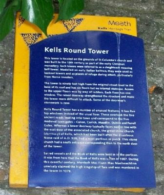
Kells Round Tower
Kells Heritage Trail
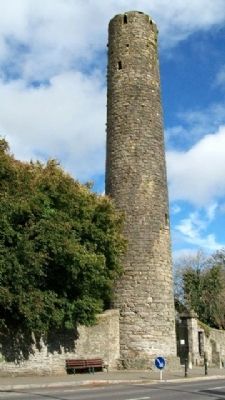
This tower is located on the grounds of St Columba's church and was built in the 10th century as part of the early Christian monastery. Such towers were referred to as a cloigteach meaning bell tower. Modelled on early Italian belfries, they were used as lookout towers and as places of refuge during attack, particularly from Norse invaders.
The tower is ninety feet high from the original street level to the base of its roof and has six floors but no internal staircase. Access to the upper floors was by way of ladders. Each floor has one window. The raised doorway strengthened the structure and made the tower more difficult to attack. Some of the doorway's stonework is new.
Kells Round Tower has a number of unusual features. It has five top windows instead of the usual four. These overlook the five ancient roads leading into town and correspond to the five medieval town gates - Canon, Carrick, Maudlin, Dublin and Farrell Gates. Whereas a tower doorway typically faces east in line with the east door of the associated church, the great stone church (damhlaig) of Kells, which had been built after the disastrous Norse raid of A.D. 920, had a west porticus or porch. This stone church had a south entrance corresponding then to the north door of the tower.
Sacred vessels and the Book of Kells were kept in in [sic] the porticus. It was from here that the Book of Kells was stolen in 1007. During this eventful century, Murdach Mac Flann Mac Maelseachlinn unwisely claimed the high kingship of Tara and was murdered in the tower in 1076.
Erected by Meath Tourism.
Topics. This historical marker is listed in these topic lists: Cemeteries & Burial Sites • Churches & Religion • Education • Forts and Castles • Landmarks • Man-Made Features • Notable Buildings • Settlements & Settlers.
Location. 53° 43.646′ N, 6° 52.862′ W. Marker is in Kells, Leinster, in County Meath. Marker is on Cannon Street (Local Road 163), on the right when traveling west. Marker and Round Tower are along the south wall of St Columba's Church. Touch for map. Touch for directions.
Other nearby markers. At least 8 other markers are within 2 kilometers of this marker, measured as the crow flies. Catherine Dempsey (within shouting distance of this marker); The Churchyard Wall (about 120 meters away, measured in a direct line); Suffolk Street (about 120 meters away); St Columba's Church (about 150 meters away); Headfort Place (approx. 0.6 kilometers away); Kells Courthouse (approx. 0.6 kilometers away); Market Cross (approx. 0.6 kilometers away); Spire of Loyd (approx. 1.7 kilometers away). Touch for a list and map of all markers in Kells.
Also see . . . Kells Round Tower. (Submitted on January 14, 2010.)
Credits. This page was last revised on August 19, 2020. It was originally submitted on January 14, 2010, by William Fischer, Jr. of Scranton, Pennsylvania. This page has been viewed 1,800 times since then and 46 times this year. Photos: 1, 2. submitted on January 14, 2010. 3. submitted on January 13, 2010.


