Center Star in Lauderdale County, Alabama — The American South (East South Central)
Center (Centre) Star
Photographed by Sandra Hughes, April 1, 2015
1. Center (Centre) Star Marker Side 1
(side 1)
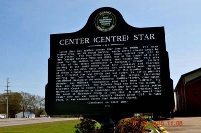
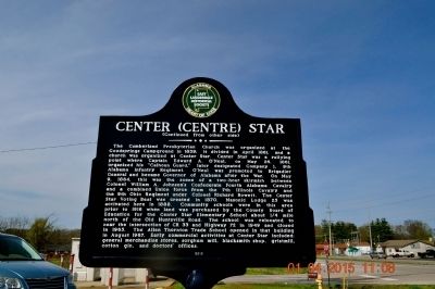
Center Star was spelled Centre Star into the 1900s. The name evolved from the US Postal Service, which served remote areas by "star routes." The Post Office here, which existed from 1850 to 1914 (except between 1902 and 1913), was the center of a star route for this section of the county, thus Centre Star. This area is one of the oldest settlements in Lauderdale County. Settlers arriving in the early 1800s found both Chickasaw and Cherokee Indians. At one time, their dividing line overlapped here. Remains of Indian villages were found southwest of this location. The land south of Center Star was fertile and was sought by cotton planters desiring the "old fields" cleared by the Indians. Plantations established throughout the area included: Phillips/Taylor, Cunningham, Douglas, and Williams. Communities near here were Bellview, Big Oak and Houstontown. The Bellview Road ran from the mouth of the Bluewater Creek to Center Star. Center Star has the oldest active Methodist congregation in Lauderdale County: it was organized near the mouth of Bluewater Creek in June 1818. It later move near Center Star and was named
this page online
Photographed by Sandra Hughes, April 1, 2015
2. Center (Centre) Star Marker side 2
Erected 2015 by East Lauderdale Historical Society.
Topics. This historical marker is listed in these topic lists: Indigenous Peoples and Communities • Settlements & Settlers • War, US Civil. A significant historical month for this entry is April 1861.
Location. 34° 51.678′ N, 87° 27.292′ W. Marker is in Center Star, Alabama, in Lauderdale County. It is at the intersection of Lee Highway (U.S. 72) and Big Oak (County Route 107), on the right when traveling east on Lee Highway. Touch for map. Marker is at or near this postal address: 6620 US 72, Killen AL 35645, United States of America. Touch for directions.

Regionally, this marker is in North Alabama and in the Shoals. It is also in the American South, specifically in the Deep South, in Appalachia, and specifically in Southern Appalachia. Globally, it is in North America, a Gulf of Mexico state,
Photographed by Sandra Hughes, April 11, 2015
3. Allen Thornton Trade School
Other nearby markers. At least 8 other markers are within 4 miles of this marker, measured as the crow flies: Earliest Methodist Congregation in Lauderdale County, Alabama (approx. ¼ mile away); Mitchell Town Community (approx. 0.9 miles away); Jesse James Gang Canal Payroll Robbery / Trial of Frank James (approx. 1.2 miles away); Gabriel Butler Cemetery (approx. 2.2 miles away); Gabriel “Old Gabe” Butler (approx. 2.2 miles away); Cherokee Chief Doublehead's Village Around 1800 (approx. 2½ miles away); Daniel White (approx. 2½ miles away); Elgin/Elgin Crossroads (approx. 3.7 miles away).
Credits. This page was last revised on January 12, 2025. It was originally submitted on April 13, 2015, by Sandra Hughes Tidwell of Killen, Alabama, USA. This page has been viewed 1,784 times since then and 140 times this year. Last updated on January 11, 2025, by Beverly Henderson of Rogersville, Alabama. Photos: 1, 2, 3. submitted on April 13, 2015, by Sandra Hughes Tidwell of Killen, Alabama, USA. • James Hulse was the editor who published this page.
