Deltaville in Middlesex County, Virginia — The American South (Mid-Atlantic)
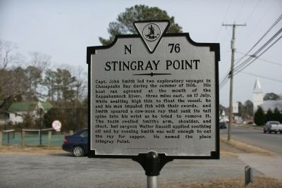
Stingray Point
Erected 2007 by Department of Historic Resources. (Marker Number N-76.)
Topics and series. This historical marker is listed in these topic lists: Animals • Colonial Era • Exploration • Waterways & Vessels. In addition, it is included in the Virginia Department of Historic Resources (DHR) series list. A significant historical year for this entry is 1608.
Location. 37° 33.267′ N, 76° 20.418′ W. Marker is in Deltaville, Virginia, in Middlesex County. Marker is on General Fuller Highway (Virginia Route 33) east of Jackson Farm Lane, on the left when traveling east. Touch for map. Marker is in this post office area: Deltaville VA 23043, United States of America. Touch for directions.
Other nearby markers. At least 8 other markers are within walking distance of this marker . Stingray Point Contraband (a few steps from this marker); F.D. Crockett (approx. ¾ mile away); Captain John Smith’s Shallop (approx. 0.8 miles away); Explorer (approx. 0.9 miles away); Deltaville Dollies (approx. 0.9 miles away); Marine Railway (approx. 0.9 miles away); Boarding Cutter (approx. 0.9 miles away); Oyster Tongs (approx. 0.9 miles away). Touch for a list and map of all markers in Deltaville.
Credits. This page was last revised on December 25, 2019. It was originally submitted on January 17, 2010, by Tom Fuchs of Greenbelt, Maryland. This page has been viewed 1,162 times since then and 27 times this year. Photo 1. submitted on January 17, 2010, by Tom Fuchs of Greenbelt, Maryland.
Editor’s want-list for this marker. A picture of Stingray Point • Can you help?
