Fort Caswell near Caswell Beach in Brunswick County, North Carolina — The American South (South Atlantic)
Fort Caswell in the Civil War
Photographed by Duane and Tracy Marsteller, November 25, 2024
1. Fort Caswell in the Civil War Marker
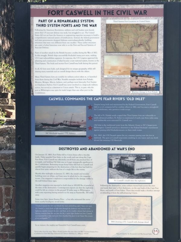
Following the American Revolution, military and civil leaders were keenly aware that U.S. seacoast defense was weak, but struggled to act. The United State did not yet have the finances or engineering expertise necessary to build a comprehensive national system of fortifications. Instead, the federal government and state governments designed defenses semi-independently, building structures that were very different from one another. These earlier structures are a part of what historians now refer to as the First and Second Systems of Seacoast Defense.
Fears of another attack by the British became a reality during the War of 1812. In this struggle, British ships successfully blockaded many port areas, making US coast vulnerabilities apparent. In response, the US Congress approved the planning and construction of what became a new national system, known as the Third System. The brick and mortar Fort Caswell was built during this period.
In all 42 forts were built, each designed for its unique geography, while still sharing many materials and an overall design
this page online
Many Third System forts are notable for military action taken at, or launched from them during the Civil War. Notable examples include forts Pulaski, Monroe, Morgan, Macon, Jackson, and, perhaps most famously, Fort Sumter in Charleston Harbor. Fort Caswell was never involved in a large-scale military action, but served as a deterrent to Union attack. This is, in part, why the port at Wilmington was open for trade longer than any other port in the Confederacy.
[Captions (top to bottom)] Third System fort locations in the United States • Fort Sumter before the war • Wartime damage to Fort Pulaski
Caswell Commands the Cape Fear River's 'Old Inlet'
★ Despite being built and maintained by the Federal Government, Fort Caswell falls to a vol. company led by a militia officer in 1861, and becomes a stronghold for Confederates, who garrison it with troops.
★ The fall of Ft. Pulaski sends a signal that Third System forts are vulnerable to newly advanced artillery. Ft. Fisher is constructed of earth, just three miles away, and earthworks soon surround Ft. Caswell, too.
★ Old Inlet is the traditional
Photographed by Duane and Tracy Marsteller, November 25, 2024
2. Fort Caswell in the Civil War Marker
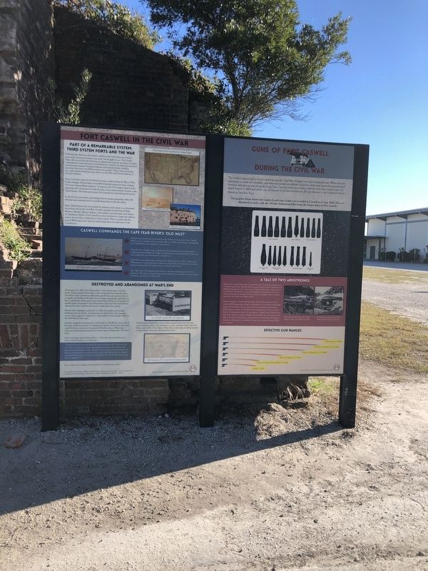
Featured marker is on the left.
★ Feb. 1863, the USS Dacotah opens fire on a steamer passing near the fort at daybreak. The guns at Caswell responded, resulting in one injury and one death aboard the assisting USS Monticello.
[Caption] NC blockade runner, CSS Advance
Destroyed and Abandoned at War's End
On January 15, 1865, Fort Fisher fell to Union forces after a two-day battle. Fisher guarded New Inlet, to the north and east along the Cape Fear River. Fort Caswell was effectively cut-off from any practical line of re-supply, and holding Old Inlet was no longer strategically significant to the Confederates. Retreating troops from Fisher fell back to Caswell and quickly began preparing for the destruction of the fort they had held for almost four years, without the loss of a single life to the enemy.
Shortly after midnight on January 17, 1865, the citadel and wooden buildings were set ablaze, and fuses were lit which led to the magazine rooms. One magazine's explosion is responsible for the damage visible to the wall behind these signs.
Another magazine was reported to hold close to 100,000 lbs of powder at the time of the destruction. Contemporary reports are that the explosion could be felt as a tremor in the ground 30 miles away in Wilmington, with some reporting having sensed it as far away as Fayetteville, 100 miles away.
Some time later, James Erastus Price – a boy who witnessed the scene from nearby Southport, would write:
“I looked toward this fort and beheld the most astonishing sight I have ever seen. As I looked, a vivid flash of light shot through he darkness and traveled with lightning rapidity toward the fort, and then, as if a mighty volcano had sprung its blazing contents from the sea into the sky, a great light flashed up from Caswell, accompanied by a roar and a jar that smashed the glass in our house like a wave of an earthquake.”*In an instant, the mighty and beautiful Fort Caswell was a ruin.
* Quote taken from the essay, “What a North Carolina Boy saw of the Civil War” by James Erastus Price as published in Under Both Flags, Richmond: B.F. Johnson Publishing Co., 1896, pp. 339-345
[Captions (top to bottom)] Ft. Caswell's citadel after the explosion • Following the destruction, some soldiers moved back across the river and made their way to Fort Anderson, on the east bank of the Cape Fear River, and north of Fort Fisher. There they would make a fruitless attempt at defending it from the still-advancing Union. • 1866 drawing of Ft. Caswell with damage detail
Erected by Brunswick Civil War Round Table.
Topics and series. This historical marker is listed in these topic lists: Forts and Castles • War, US Civil • Waterways & Vessels. In addition, it is included in the National Register of Historic Places (NRHP) series list. A significant historical date for this entry is January 17, 1865.
Location. 33° 53.587′ N, 78° 1.066′ W. Marker is near Caswell Beach, North Carolina, in Brunswick County. It is in Fort Caswell. It can be reached from Caswell Beach Road 2.4 miles east of Oceangreens Lane, on the right when traveling east. It is north of Hatch Auditorium within Fort Caswell Coastal Retreat and Conference Center. Touch for map. Marker is in this post office area: Oak Island NC 28465, United States of America. Touch for directions.

Regionally, this marker is in the Coastal Plain and on the Cape Fear Coast. It is also in the American South, specifically in the Upper South, in the Tidewater, and on the Eastern Seaboard. Globally, it is in the North Atlantic Region, North America, the Western Hemisphere, the Western World, and the Anglosphere. Historically, it finds itself in what was once the territory of the Mississippian Culture, one of the original Thirteen Colonies, one of the Confederate States of America, and the Antebellum South.
Other nearby markers. At least 8 other markers are within 2 miles of this marker, measured as the crow flies: Guns of Fort Caswell During the Civil War (here, next to this marker); Fort Caswell (within shouting distance of this marker); A Timeline of Fort Caswell (within shouting distance of this marker); Battery Madison (about 400 feet away, measured in a direct line); Battery Bagley (approx. 0.4 miles away); Battery Shipp (approx. half a mile away); Catalino Tingzon (approx. 1.7 miles away); Revolutionary War Fort (approx. 1.7 miles away). Touch for a list and map of all markers in Caswell Beach.
More about this marker. Access to Fort Caswell, now a private Baptist retreat and conference center, is limited to authorized visitors as well as during special events that are open to the public. Visit fortcaswell.com/ or call (910) 278-9501 for more information.
Also see . . . Fort Caswell Historic District (PDF). National Register of Historic Places nomination for the district, which was listed in 2013. (Prepared by Jennifer Martin Mitchell; via North Carolina State Historic Preservation Office) (Submitted on March 4, 2025, by Duane and Tracy Marsteller of Murfreesboro, Tennessee.)
Credits. This page was last revised on March 5, 2025. It was originally submitted on March 4, 2025, by Duane and Tracy Marsteller of Murfreesboro, Tennessee. This page has been viewed 371 times since then and 74 times this year. Photos: 1, 2. submitted on March 4, 2025, by Duane and Tracy Marsteller of Murfreesboro, Tennessee.
