
Chamberlain Township in Brule County, South Dakota — The American Midwest (Upper Plains)
Language, Contributions, Regional Tribes

Photographed by Sandra Hughes Tidwell, August 19, 2024
1. Language.Contributions.Regional Tribes Marker
Language
Although they speak the same language, there are three distinct dialects that each of the three divisions speak. Those dialects are seen in each division, named Dakota, Nakota, and Lakota. Regardless of the dialect, the meaning of the name of these tribes remains the same: Friendly Ally.
Contributions
Dating as far back as the earliest recorded history of the Great Plains, the Dakota, Nakota, and Lakota people have a rich history of existence in these homelands and made great contributions to the earliest explorers of this region, documenting geographical markers, sharing knowledge of the area and maintaining a dominant presence on the Great Plains.
The Sioux nation has many distinguished chiefs and warriors that shaped America and American history. Recognized throughout the world, some of the most notable men, such as Standing Buffalo, Red Cloud, Sitting Bull, and Crazy Horse, among many others, called South Dakota home.
Throughout the 19th and early 20th centuries, the ancestral people of the Great Plains experienced and suffered many challenges during the expansion of the United States. However,
this page online
In both these World Wars, the Sioux and other tribal languages were indecipherable and used as "code" to transmit messages on the front lines. This resulted in an unbreakable code and helped the United States win both conflicts. South Dakota is home to dozens of "Sioux Code Talkers.”
Each of these tribes carries on their ancestral language, culture, and history. This can be seen in each community and most commonly by visitors from throughout the world who attended the native dance celebrations commonly known as Powwows. The native culture, language, and history is intertwined in South Dakota history and American history and is vital to the acknowledgment and protection of a great tribal nation that made many contributions to South Dakota and America as a whole.
Regional Tribes
Although South Dakota is known as the ancestral homeland of the Great Sioux Nation, many other tribes roamed and hunted in different parts of South Dakota, as evidenced by different historical
Photographed by Sandra Hughes Tidwell, August 19, 2024
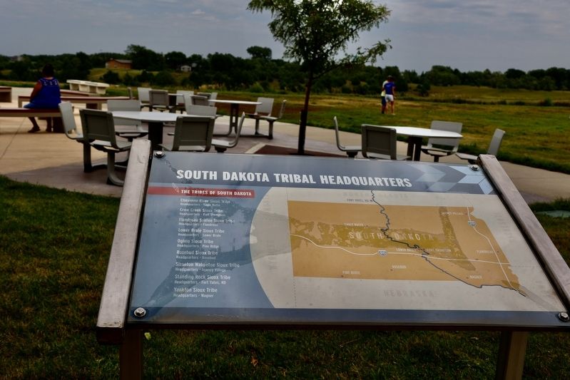
2. South Dakota Tribal Headquarters
The tribes of South Dakota
Cheyenne River Sioux Tribe
Headquarters - Eagle Butte
Crow Creek Sioux Tribe
Headquarters - Fort Thompson
Flandreau Santee Sioux Tribe
Headquarters - Flandreau
Lower Brule Sioux Tribe
Headquarters - Lower Brule
Ogala Sioux Tribe
Headquarters - Pine Ridge
Rosebud Sioux Tribe
Headquarters - Rosebud
Sisseton Wahpeton Sioux Tribe
Headquarters - Agency Village
Standing Rock Sioux Tribe
Headquarters - Fort Yates, ND
Yankton Sioux Tribe
Headquarters - Wagner
Topics. This historical marker is listed in these topic lists: Anthropology & Archaeology • Indigenous Peoples and Communities • War, World II.
Location. 43° 47.211′ N, 99° 20.302′ W. Marker is in Chamberlain, South Dakota, in Brule County. It is in Chamberlain Township. It is on I-90 East (U.S. 90). These markers are near the Dignity Statue. Touch for map. Marker is at or near this postal address: Chamberlain SD Rest Area facility, Chamberlain SD 57325, United States of America. Touch for directions.

Regionally, this marker is in East River. It is also in the American Lewis & Clark Corridor, on the prairies, and on the Northern Plains. Globally, it is in North America, the Western Hemisphere, the Western World, and the Anglosphere. Historically, it finds itself in what was once Rupert’s Land and also the Louisiana Purchase.
Other nearby markers. At least 8 other markers are within walking distance of this marker: Dignity (a few steps from this marker); Missouri River Bridges of South Dakota (within shouting distance of
Photographed by Sandra Hughes Tidwell, August 19, 2024
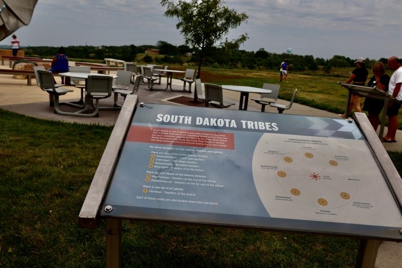
3. South Dakota Tribes
South Dakota is rich in native history and is home to nine tribes that originate from the o'ceti Sakowin or Seven Council Fires and are more commonly referred to by treaty as the Great Sioux Nation.
Known throughout the world, The Great Sioux Nation is divided into three divisions, with each division having one or more bands.
The three divisions are the Dakota, Nakota, and Lakota.
There are four bands of the Dakota division:
1. Mdbewaktonwan - Spirit Lake dwellers
2. Sisitonwan - Fish village dwellers
3. Wahpetonwan - Woodland dwellers
4. Wahpekute - Shooters from the leaves.
There are two bands of the Nakota division:
5. Ihanktonwan -Dwellers at the end of the village
6. Ihanktonwanna - Dwellers at the far end of the village
There is one band of Lakota:
7. Titonwan - Dwellers of the prairie
Each of these bands are also broken down into sub-bands.
Lakota - Dakota - Nakota
1. Mdbewaktonwan (Spirit Lake Dwellers)
2. Sisitonwan (Fish Village Dwellers)
3. Wahpetonwan (Woodland Dwellers)
4. Wahpekute (Shooters From the Leaves)
5. Ihanktonwan (Dwellers at the end of the Village)
6. Ihanktonwanna (Dwellers at the Far End of the Village)
7. Titonwan (Dwellers of the Prairie)
O'ceti (Fire Place)
Other markers no longer nearby. The Making & Meaning of Dignity (was a few steps from this marker but has been replaced with another marker now near it); Mount Rushmore National Memorial (was about 300 feet away but has been permanently removed); World's Only Corn Palace - Mitchell (was about 300 feet away but has been permanently removed); State Capitol - Pierre (was about 300 feet away but has been permanently removed).
Credits. This page was last revised on May 5, 2025. It was originally submitted on March 10, 2025, by Sandra Hughes Tidwell of Killen, Alabama, USA. This page has been viewed 103 times since then and 15 times this year. Photos: 1, 2, 3. submitted on March 10, 2025, by Sandra Hughes Tidwell of Killen, Alabama, USA. • Andrew Ruppenstein was the editor who published this page.
