Menands in Albany County, New York — The American Northeast (Mid-Atlantic)
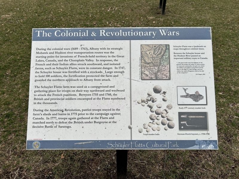
The Colonial & Revolutionary Wars
Schuyler Flatts Cultural Park
Photographed by Steve Stoessel, March 22, 2025
1. The Colonial & Revolutionary Wars Marker
The Schuyler Flatts farm was used as a campground and gathering place for troops on their way northward and westward to attack the French positions. Between 1755 and 1760, the British and provincial soldiers encamped at the Flatts numbered in the thousands.
During the American Revolution, patriot troops stayed in the farm's sheds and barns in 1775 prior to the campaign against Canada. In 1777, troops again gathered at the Flatts and marched north to defeat the British under Burgoyne at the decisive Battle of Saratoga.
Schuyler Flatts was a landmark on maps throughout colonial
this page online
Between the Schuyler house and the Hudson River passed an important military route to Canada.
"...the great north road, the highway of the pioneer, the settler, the trader, of brave armies, of troop and commander, the path over which the brilliant and gallant young Howe led his force to the fight of Lake George, and over which, the captive Burgoyne rode by the side of his conqueror." J.H. Bogart, 1855.
Erected by Town of Colonie.
Topics. This historical marker is listed in these topic lists: War, French and Indian • War, US Revolutionary • Wars, Non-US. A significant historical year for this entry is 1747.
Location. 42° 42.359′ N, 73° 42.52′ W. Marker is in Menands, New York, in Albany County. It can be reached from Schuyler Lane, on the right when traveling north. Marker is approximately 0.1 miles from parking area. Touch for map. Marker is at or near this postal address: Schuyler Flatts Cultural Park, Watervliet NY 12189, United States of America. Touch for directions.

Regionally, this marker is in Upstate New York, in the Capital District, and in the Albany Metropolitan Area. It is also in the American
Photographed by Steve Stoessel, March 22, 2025
2. The Colonial & Revolutionary Wars Marker
Other nearby markers. At least 8 other markers are within walking distance of this marker: Arent van Curler & Fr. Isaac Jogues at the Flatts in 1643 (here, next to this marker); The Old Schuyler Burying Ground (within shouting distance of this marker); Schuyler Flatts in the French & Indian War (about 500 feet away, measured in a direct line); The Native People (about 500 feet away); Schuyler Flatts Cultural Park (about 500 feet away); Schuyler Flatts (about 500 feet away); Meneely Bell From St. Brigid's Church (approx. 0.2 miles away); a different marker also named Schuyler Flatts (approx. 0.2 miles away). Touch for a list and map of all markers in Menands.
Credits. This page was last revised on April 29, 2025. It was originally submitted on March 24, 2025, by Steve Stoessel of Niskayuna, New York. This page has been viewed 232 times since then and 19 times this year. Photos: 1, 2. submitted on March 24, 2025, by Steve Stoessel of Niskayuna, New York.
