Quinnipiac Meadows in New Haven in South Central Region, Connecticut — The American Northeast (New England)
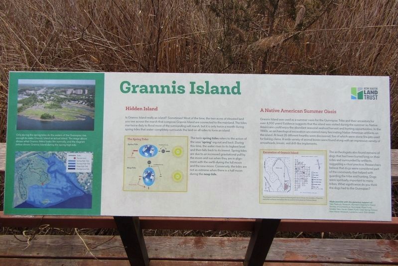
Grannis Island
A Native American Summer Oasis
Photographed by Conrad Ward, March 31, 2024
1. Grannis Island Marker
Grannis Island was used as a summer oasis for the Quinnipiac Tribe and their ancestors for over 4,000 years! Evidence suggests that the island was visited during the summer so Native Americans could enjoy the abundant seasonal seafood harvest and hunting opportunities. In the 1940s, an archaeological excavation uncovered many fascinating Native American artifacts on the island. At least 26 different hearths were discovered, five of which were stone fire pits used for baking clams. A wide variety of animal bones were found along with an impressive variety of arrowheads, knives, and drill-like implements.
The archeologists also found remains of dogs that had been buried lying on their sides and surrounded by artifacts, suggesting a ritual practice. Researchers believe that dogs were considered part of the community that helped with guarding the tribe and hunting. Dogs were spiritually important to many tribes. What significance do you think the dogs had to the Quinnipiac?
(Maps)
Excavation of Grannis Island
This diagram from the original archeological report shows the location of hearths and other artifacts and where
this page online
Made possible with the generous support of:
Yale Peabody Museum, Woman's Seamen's Friend Society of Connecticut, Quinnipiac River Fund, Greater New Haven Green Fund, Cold Spring School, New Haven Museum, Lucianne Lavin, Erin Gredell
Erected by New Haven Land Trust.
Topics. This historical marker is listed in these topic lists: Animals • Anthropology & Archaeology • Indigenous Peoples and Communities.
Location. 41° 18.979′ N, 72° 52.855′ W. Marker is in New Haven in South Central Region, Connecticut. It is in Quinnipiac Meadows. It can be reached from Quinnipiac Avenue. Located in the Quinnipiac Meadows/Eugene B. Fargeorge Nature Preserve. Touch for map. Marker is at or near this postal address: 1040 Quinnipiac Ave, New Haven CT 06513, United States of America. Touch for directions.

Regionally, this marker is in the Connecticut River Valley and on the Connecticut Shoreline. It is also in the American Northeast, in New England, and on the Eastern Seaboard. Globally, it is in the North Atlantic Region, North America,
Photographed by Conrad Ward, March 31, 2024
2. Grannis Island Marker
Other nearby markers. At least 8 other markers are within 2 miles of this marker, measured as the crow flies: Welcome to the Preserve (about 800 feet away, measured in a direct line); The Quinnipiac River (approx. half a mile away); The Quinnipiac Marsh Timeline (approx. 0.7 miles away); How have people changed the marsh? (approx. 0.7 miles away); New Haven World War Two Veterans Memorial (approx. 1.4 miles away); Soldiers and Sailors Monument (approx. 1.4 miles away); a different marker also named Soldiers' and Sailors' Monument (approx. 1½ miles away); Discover New Haven! (approx. 1½ miles away). Touch for a list and map of all markers in New Haven.
Credits. This page was last revised on May 19, 2026. It was originally submitted on March 27, 2025, by Conrad Ward of Guilford, Connecticut. This page has been viewed 152 times since then and 46 times this year. Photos: 1, 2. submitted on March 27, 2025, by Conrad Ward of Guilford, Connecticut. • Andrew Ruppenstein was the editor who published this page.
