Spring Grove in Surry County, Virginia — The American South (Mid-Atlantic)
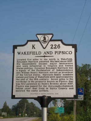
Wakefield and Pipsico
Erected 2003 by Department of Historic Resources. (Marker Number K-226.)
Topics and series. This historical marker is listed in these topic lists: Colonial Era • Native Americans • Settlements & Settlers. In addition, it is included in the Former U.S. Presidents: #09 William Henry Harrison, the Signers of the Declaration of Independence, and the Virginia Department of Historic Resources (DHR) series lists. A significant historical year for this entry is 1637.
Location. 37° 9.932′ N, 76° 58.401′ W. Marker is in Spring Grove, Virginia, in Surry County. Marker is at the intersection of Colonial Trail West (Virginia Route 10) and Martin Luther King Highway (Virginia Route 40), on the right when traveling west on Colonial Trail West. Touch for map. Marker is at or near this postal address: 17 Swanns Point Rd, Spring Grove VA 23881, United States of America. Touch for directions.
Other nearby markers. At least 8 other markers are within 5 miles of this marker, measured as the crow flies. Temperance Industrial and Collegiate Institute (here, next to this marker); Swann’s Point (within shouting distance of this marker); Cabin Point (approx. 3˝ miles away); Claremont School (approx. 3.6 miles away); Claremont (approx. 3.7 miles away); Quioughcohanach Indians (approx. 4.3 miles away); Jerusalem Baptist Church (approx. 4.8 miles away); Glebe House of Southwark Parish (approx. 4.9 miles away). Touch for a list and map of all markers in Spring Grove.
Credits. This page was last revised on June 16, 2016. It was originally submitted on September 23, 2007, by Laura Troy of Burke, Virginia. This page has been viewed 1,394 times since then and 35 times this year. Photo 1. submitted on September 23, 2007, by Laura Troy of Burke, Virginia. • J. J. Prats was the editor who published this page.
