USCG Training Center Yorktown in York County, Virginia — The American South (Mid-Atlantic)
Civil War Trenches

Photographed by Evan Dwyer, March 8, 2025
1. Civil War Trenches Marker
Topics. This historical marker is listed in these topic lists: Forts and Castles • War, US Civil. A significant historical month for this entry is April 1862.
Location. 37° 12.987′ N, 76° 28.688′ W. Marker is in Yorktown, Virginia, in York County. It is in USCG Training Center Yorktown. It is on Perimeter Road 0.4 miles east of Nelson Street & Hamilton/Perimeter Road, on the left. The marker is on post at USCG Training Center Yorktown, across from the Perimeter Road Baseball Field backstop. This is a secured installation and the general public cannot access this location without a credentialed escort. Touch for map. Marker is in this post office area: Yorktown
this page online

Regionally, this marker is on Virginia’s Peninsula, in Coastal Virginia, and in the Hampton Roads Metropolitan Area. It is also in the American South, specifically in the Upper South, in the Tidewater, and on the Eastern Seaboard. Globally, it is in the North Atlantic Region, North America, the Western Hemisphere, the Western World, and the Anglosphere. Historically, it finds itself in what was once the territory of the Mississippian Culture, one of the original Thirteen Colonies, one of the Confederate States of America, and the Antebellum South.
Other nearby markers. At least 8 other markers are within walking distance of this marker: Yorke Village (about 300 feet away, measured in a direct line); Early Settlement Along Wormley's Creek (about 400 feet away); Major William Gooch Of This Parish (about 400 feet away); The Seventeenth-Century Churches of York Parish (about 400 feet away); Archaeological Excavations (about 400 feet away); Revenue Cutter Surveyor (approx. 0.4 miles away); Moore House (approx. 0.6 miles away); Wear Of Centuries (approx. ¾ mile away).

Photographed by Evan Dwyer, March 8, 2025
2. Civil War Trenches Marker & Trench
More about this marker. The trench begins at the fence line east of the tennis court and is interrupted by pavement. It resumes and runs in the grass between the south and north sides of the Yeaton Drive half loop.
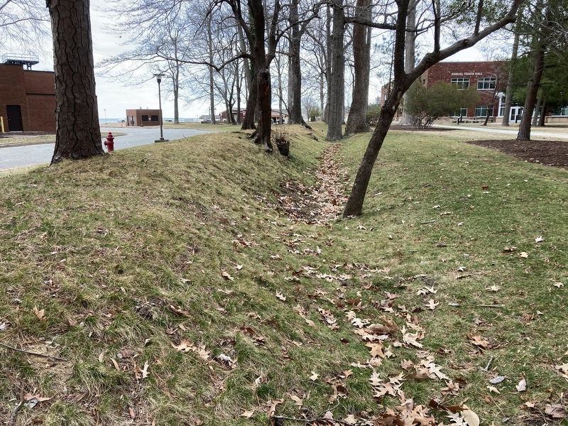
Regarding Civil War Trenches. The type of trench described by the marker is a covered way - a deep, wide trench specifically for troop movement, rather than being manned continuously as part of a line of fortifications. The "covered" part was the excavated dirt that provided "cover" for troops moving in the trench - though the name implies otherwise, covered ways did not have a "cover" or a roof over them.
Photographed by Evan Dwyer, March 8, 2025
3. Civil War Trenches
This is the longer of the two trench sections at USCG TRACEN Yorktown, facing north from Yeaton Dr. Yeaton Drive bends around the east edge of Wormley Creek's north bank, and this trench line runs across the middle area between the bends north & south branches.

Photographed by Evan Dwyer, March 8, 2025
4. Civil War Trenches
The same run of trench, but viewed facing south from near the north branch of Yeaton Drive. Both photos show the interior side, so US troops would have been protected by the earthen berm - Confederate forces were to the west, so the berm would have kept US troops out of view while also shielding them from bullets and cannon fire.

Photographed by Evan Dwyer, March 8, 2025
5. Confederate Water Battery
Though not the trenches referenced in the marker, there is a related earthwork - but Confederate, not Federal - beyond the north branch of Yeaton Drive. This chevron-shaped fortification was built in 1862 (like the Federal trench, but a couple months earlier) to guard the mouth of Wormley Creek, but it was abandoned when the Confederates withdrew to the Yorktown-Warwick Line to the west. The battery is east of all the USCG shops and buildings, about 1700 feet (0.3 miles) east of the marker.

Photographed by Evan Dwyer, March 8, 2025
6. Confederate Water Battery
This is the apex and outer ditch of the Confederate Water Battery at the mouth of Wormley Creek, 1700 feet (0.3 miles) from the marker. Note, this is not the "trenches" referenced by the marker, which end 800' to the west of this spot.
Credits. This page was last revised on April 20, 2025. It was originally submitted on April 17, 2025, by Evan Dwyer of Richmond, Virginia. This page has been viewed 254 times since then and 63 times this year. Photos: 1, 2, 3, 4, 5, 6. submitted on April 17, 2025, by Evan Dwyer of Richmond, Virginia. • Andrew Ruppenstein was the editor who published this page.
