Hayes in Gloucester County, Virginia — The American South (Mid-Atlantic)
Fairfield Plantation
Ash Pit, Clay Borrow Pit & Fence Line
| — | Fairfield Plantation | — |
Photographed by Brandon D Cross
1. Fairfield Plantation Marker
this page online
(caption)
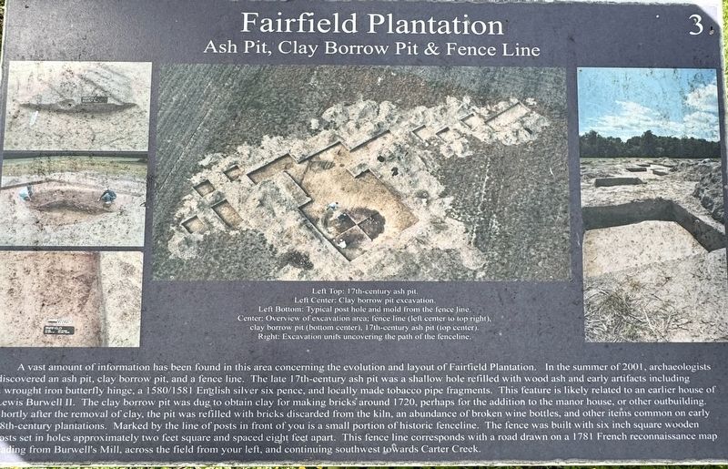
Left Top: 17th-century ash pit.
Left Center: Clay borrow pit excavation.
Left Bottom: Typical post hole and mold from the fence line
Center: Overview of excavation area; fence line (left center to top right), clay borrow pit (bottom center), 17th-century ash pit (top center)
Right: Excavation units uncovering the path of the fenceline.
Erected by Fairfield Foundation. (Marker Number #3.)
Topics. This historical marker is listed in these topic lists: Anthropology & Archaeology • Colonial Era. A significant historical year for this entry is 1780.
Location. 37° 20.467′ N, 76° 33.223′ W. Marker is in Hayes, Virginia, in Gloucester County. It is on Fairfield Lane 0.4 miles west of Cedar Bush Road, on the right when traveling north. The marker is located within Fairfield Archaeology Park. Touch for map. Marker is at or near this postal address: 5777 Fairfield Lane, Hayes VA 23072, United States of America. Touch for directions.

Regionally, this marker is on the Middle Peninsula and in the Hampton Roads Metropolitan Area.
Photographed by Brandon D Cross
2. Fairfield Plantation Marker
Other nearby markers. At least 8 other markers are within 2 miles of this marker, measured as the crow flies: The Fairfield Manor House (a few steps from this marker); a different marker also named The Fairfield Manor House (a few steps from this marker); a different marker also named The Fairfield Manor House (a few steps from this marker); a different marker also named The Fairfield Manor House (within shouting distance of this marker); Outside the Manor (within shouting distance of this marker); East Pavilion Wall (approx. 1½ miles away); North Façade (approx. 1½ miles away); South Façade (approx. 1½ miles away). Touch for a list and map of all markers in Hayes.
Also see . . .
1. Fairfield Plantation. (Submitted on April 18, 2025, by Brandon D Cross of Flagler Beach, Florida.)
2. Fairfield Plantation (Gloucester Co.). (Submitted on April 18, 2025, by Brandon D Cross of Flagler Beach, Florida.)
3. Digs & Discoveries - Fairfield’s Rebirth in 3-D …. (Submitted on April 18, 2025, by Brandon D Cross of Flagler Beach, Florida.)
Credits. This page was last revised on April 20, 2025. It was originally submitted on April 18, 2025, by Brandon D Cross of Flagler Beach, Florida. This page has been viewed 198 times since then and 49 times this year. Photos: 1, 2. submitted on April 18, 2025, by Brandon D Cross of Flagler Beach, Florida. • Andrew Ruppenstein was the editor who published this page.
