Eyre Square in Galway in County Galway, Connacht, Ireland — Irish West ((Éire) North Atlantic Ocean)
History of Eyre Square
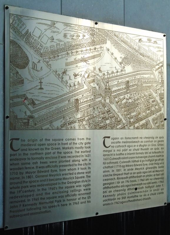
Photographed by William Fischer, Jr., April 6, 2025
1. History of Eyre Square Marker
The origin of the square comes from the medieval open space in front of the city gate and known as the Green. Markets mostly took part in the northern part of the space. The earliest endeavor to formally enclose it was recorded in 1631 when some ash trees were planted along with a wooden fence. It was officially presented to the city in 1710 by Mayor Edward Eyre, from whom it took its name. In 1801, General Meyrick erected a stone wall around the space and it became Meyrick Square. The whole park was redeveloped in the Georgian style in the 19th century. In the 1960's the square was again redeveloped and the enclosing railings were removed. In 1965 the square was officially renamed John F Kennedy Memorial Park in honour of the US President following his speech here in 1963 and his subsequent assassination.
Tagann an tionscnamh na chearnóg ón spás oscailte meánaoiseach os comhair an geata na cathrach agus ar a dtugtar an Glas. Ghlac margaí is mó páirt sa chuid thuaidh an spás. An iarracht is luaithe a iniamh formaly bhí sé taifeadla in 1631 Cuireadh roinnt crann fuinseoige chomh maith le fál adhmaid. Cuireadh i láthair
this page online
Topics. This historical marker is listed in these topic lists: Colonial Era • Parks & Recreational Areas • Settlements & Settlers. A significant historical year for this entry is 1631.
Location. 53° 16.421′ N, 9° 2.963′ W. Marker is in Galway, Connacht, in County Galway. It is in Eyre Square. It is at the intersection of Eyre Square/An Faiche Mohr and Ballalley Lane, on the right when traveling south on Eyre Square/An Faiche Mohr. Marker is near the Eyre Square Centre east entrance opposite Eyre Square. Touch for map. Marker is in this post office area: Galway, Connacht H91 D527, Ireland. Touch for directions.

Regionally, it is on the Atlantic Ocean, in the North Atlantic Region, on the Atlantic Arc, in Europe, on the Island of Ireland, on the Celtic Fringe, in the European Union, in Atlantic Europe, on one of the British Isles, in the Western World, and in the Anglosphere.
Other nearby markers. At least 8 other markers are within walking distance of this marker: Medieval Town Hall/
Credits. This page was last revised on December 3, 2025. It was originally submitted on April 19, 2025, by William Fischer, Jr. of Reynoldsburg, Ohio. This page has been viewed 137 times since then and 37 times this year. Photo 1. submitted on April 19, 2025, by William Fischer, Jr. of Reynoldsburg, Ohio.
