Charles City in Charles City County, Virginia — The American South (Mid-Atlantic)
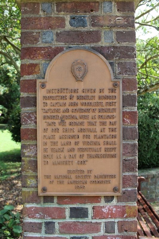
Instructions Given
Photographed by Evan Dwyer, August 31, 2024
1. Instructions Given Marker
Erected by The National Society Daughters of the American Colonists 1969
Erected 1969 by the National Society Daughters of the American Colonists.
Topics and series. This historical marker is listed in these topic lists: Anthropology & Archaeology • Colonial Era. In addition, it is included in the Daughters of the American Colonists series list. A significant historical year for this entry is 1619.
Location. 37° 18.95′ N, 77° 10.838′ W. Marker is in Charles City, Virginia, in Charles City County. It can be reached from Harrison Landing Road 0.8 miles south of Westover Road. Marker is within Berkeley Plantation, on a brick pillar east of the central walkway through the middle of the gardens and terraces. Touch for map. Marker is at or near this postal address: 12602 Harrison Landing Rd, Charles City VA 23030, United States of America. Touch for directions.

Regionally, this marker is in Coastal Virginia. It is also in the American South, specifically in the Upper South, in the Tidewater, and on the Eastern Seaboard. Globally, it is in the North Atlantic Region, North America, the Western Hemisphere, the Western World, and the Anglosphere. Historically, it finds itself in what was once the territory of the Mississippian Culture, one of the original Thirteen Colonies, one of the Confederate States of America, and the Antebellum South.
Other nearby markers. At least 8 other markers are within walking distance of this marker: Commemorating the 350th Anniversary at Berkeley Hundred
this page online
Other markers no longer nearby. Lane to Site of First Thanksgiving (was about 400 feet away, measured in a direct line but has been replaced with another marker now near it); Cannon Ball (was about 500 feet away but has been confirmed missing).

Photographed by Evan Dwyer, August 31, 2024
2. Instructions Given Marker
Marker is on the pillar to the right.
Credits. This page was last revised on May 1, 2025. It was originally submitted on April 21, 2025, by Evan Dwyer of Richmond, Virginia. This page has been viewed 159 times since then and 33 times this year. Photos: 1, 2. submitted on April 21, 2025, by Evan Dwyer of Richmond, Virginia. • Bernard Fisher was the editor who published this page.
