North Quincy in Norfolk County, Massachusetts — The American Northeast (New England)
South of Boston Discovery Area
Photographed by Conrad Ward, November 17, 2024
1. South of Boston Discovery Area Marker
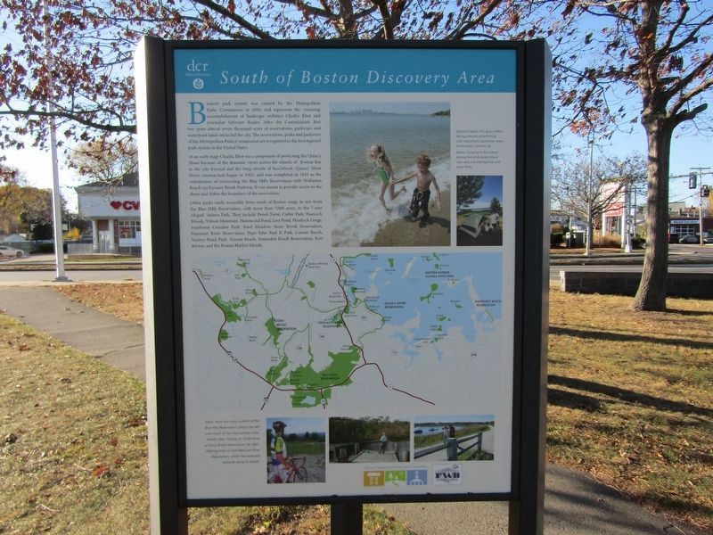
Boston's park system was created by the Metropolitan Parks Commission in 1893, and represents the crowning accomplishment of landscape architect Charles Eliot and journalist Sylvester Baxter. After the Commission's first two years almost seven thousand acres of reservations, parkways and waterfront lands encircled the city. The reservations, parks and parkways of the Metropolitan Parks Commission are recognized as the first regional park system in the United States.
At an early stage Charles Eliot was a proponent of protecting the Quincy Shore because of the dynamic views across the islands of Boston Bay to the city beyond and the long stretch of beachfront. Quincy Shore Drive construction began in 1903, and was completed in 1929 as the culmination of connecting the Blue Hills Reservation with Wollaston Beach via Furnace Brook Parkway. It was meant to provide access to the shore and define the boundary of the reservation.
Other parks easily accessible from south of Boston range in size from the Blue Hills Reservation, with more than 7,000 acres, to the 7-acre Abigail Adams Park. They include Brook Farm, Cutler Park,
this page online
Erected by Massachusetts Department of Conservation & Recreation (DCR).
Topics. This historical marker is listed in these topic lists: Parks & Recreational Areas • Roads & Vehicles. A significant historical year for this entry is 1893.
Location. 42° 17.262′ N, 71° 1.377′ W. Marker is in Quincy, Massachusetts, in Norfolk County. It is in North Quincy. It is at the intersection of Quincy Shore Drive and East Squantum Street, on the right when traveling west on Quincy Shore Drive. Touch for map. Marker is in this post office area: Quincy MA 02171, United States of America. Touch for directions.

Regionally, this marker is in Historic Boston and specifically in Greater Boston. It is also in the American Northeast, in New England, and on the Eastern Seaboard. Globally, it is in the North Atlantic Region, North America, the
Photographed by Conrad Ward, November 17, 2024
2. South of Boston Discovery Area Marker
Other nearby markers. At least 8 other markers are within one mile of this marker, measured as the crow flies: Moswetuset Hummock (a few steps from this marker); a different marker also named Moswetuset Hummock (about 600 feet away, measured in a direct line); a different marker also named Moswetuset Hummock (about 700 feet away); WWII Paratroopers and Veterans Memorial (about 700 feet away); Squantum Point Through Time (approx. one mile away); New England's First Aero Meet (approx. one mile away); Maloney Circle (approx. one mile away); Harriet Quimby's Last Flight (approx. one mile away). Touch for a list and map of all markers in Quincy.
Credits. This page was last revised on May 8, 2025. It was originally submitted on April 25, 2025, by Conrad Ward of Guilford, Connecticut. This page has been viewed 130 times since then and 23 times this year. Photos: 1, 2. submitted on April 25, 2025, by Conrad Ward of Guilford, Connecticut. • Michael Herrick was the editor who published this page.
