South Boston in Suffolk County, Massachusetts — The American Northeast (New England)
Creating Pleasure Bay
South Boston
Photographed by Conrad Ward, January 1, 1980
1. Creating Pleasure Bay Marker
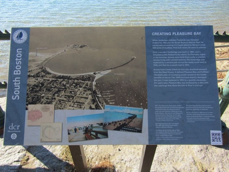
When landscape architect Frederick Law Olmsted drafted his 1883 plan for South Boston's Marine Park, be envisioned connecting it to Castle Island by filling in some 600 acres of mudflats. That took nearly 50 years to achieve.
First a wooden footbridge was built in 1892, and a delighted public flocked to the island. On Thursday nights in the summer, dances were held there under a wooden canopy hung with colored lanterns. The footbridge was replaced by a cement path across the newly made land in 1928 and then by a paved road in 1932.
Across from Castle Island an iron pier stretched seaward from the Head House. It defined Pleasure Bay and fulfilled Olmsted's plan of increasing public access to the health benefits of sea air. The 1938 hurricane heavily damaged the pier; it was replaced in 1953 by a granite causeway. Six years later, Pleasure Bay was enclosed by a dike with two openings that allow the tide to flow in and out.
(photo captions)
Top This 1925 aerial photo shows where soil dredged from both the Reserved Channel and Pleasure Bay was being dumped to make new land between Castle Island and
this page online
~Courtesy of Boston Public Library
Bottom images left to right The 1880 map shows Castle Island nearly a half-mile offshore.
Frederick Law Olmsted's original 1883 plan called for Marine Park to be connected to Castle Island and the area in between to be named Pleasure Bay.
~Map and plan courtesy of Norman B. Leventhal Map & Education Center at Boston Public Library
The footbridge gave the public access to Castle Island for the first time and attracted hundreds, especially on weekends.
An iron pier built in 1896 led out to what was then called Head Island and is now known as the Sugar Bowl. A wooden canopy over part of the pier provided shade.
~Postcards courtesy of James Sullivan, Postcard History of South Boston
Erected by Boston Harborwalk & Department of Conservation & Recreation (DCR).
Topics. This historical marker is listed in these topic lists: Bridges & Viaducts • Environment • Parks & Recreational Areas.
Location. 42° 20.291′ N,

Photographed by Conrad Ward, November 17, 2024
2. Creating Pleasure Bay Marker

Regionally, this marker is in Massachusetts’ Historic Boston. It is also in the American Northeast, in New England, and on the Eastern Seaboard. Globally, it is in the North Atlantic Region, North America, the Western Hemisphere, the Western World, and the Anglosphere. Historically, it finds itself in what was once one of the original Thirteen Colonies.
Other nearby markers. At least 8 other markers are within walking distance of this marker: Many Forts, Many Uses (about 600 feet away, measured in a direct line); Harbor of Shame No More (about 800 feet away); Donald McKay Monument (approx. 0.2 miles away); Bob Greene the Firefighter... (approx. 0.2 miles away); From Paradise to Prison (approx. 0.2 miles away); Harbor Mines Explosion (approx. 0.2 miles away); South Boston Korean War Memorial (approx. 0.2 miles away); John E. Powers (approx. 0.6 miles away). Touch for a list and map of all markers in Boston.
Credits. This page was last revised on May 11, 2025. It was originally submitted on April 27, 2025, by Conrad Ward of Guilford, Connecticut. This page has been viewed 441 times since then and 124 times this year. Photos: 1. submitted on April 27, 2025, by Conrad Ward of Guilford, Connecticut. 2. submitted on May 10, 2025, by Conrad Ward of Guilford, Connecticut. • Michael Herrick was the editor who published this page.
