Seaport (South Boston) in Suffolk County, Massachusetts — The American Northeast (New England)
Transformed Tidal Flats
South Boston
Photographed by Conrad Ward, November 17, 2024
1. Transformed Tidal Flats Marker
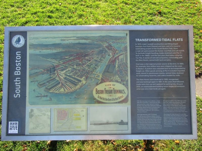
In 1873, major seawall construction and filling began between Fort Point Channel and here, part of a massive landmaking project on the South Boston Flats. Soon, a vast rail yard covered the former mud flats and salt marsh. To facilitate freight handling, tracks stretched onto Pier 4—built in the 1880s—and the two piers that today comprise Fan Pier. A series of railroad companies, culminating with the New Haven, owned both land and piers.
Coal was a vital regional power source at the time. In 1900, for example, four million tons were shipped up the coast to Boston. A portion was unloaded here to be transported by freight car. Other goods arriving at Pier 4 included imported wool, stored in warehouses nearby, animal hides destined for shoemaking factories, and cotton headed for mills.
The New Haven went bankrupt in 1935, reorganized, and was bankrupt again in 1961. In the years that followed, tracks were torn up and replaced by parking lots. Around 2010, an unprecedented building boom began to transform what was once tidal lands yet again.
(captions)
Top Like most large piers in Boston around
this page online
Bottom images left to right
The 1817 survey of Boston Harbor shows a smattering of houses in a rural South Boston and the enormous tidal flats known as South Boston Flats. By the end of the 19th century, the flats were filled. Across the harbor, Bird and Governor's Islands would become part of Logan Airport. ~Boston Harbor Chart by Alexander Wadsworth, published in 1819. Courtesy of the Norman B. Leventhal Map & Education Center, Boston Public Library
Everything shown on this 1919 map is new land. The original South Boston shoreline was roughly along First Street. Total landmaking in South Boston was second only to what was required to create Logan Airport. ~Atlas of the City of Boston, South Boston by G.W. Bromley & Co. Courtesy of the Norman B. Leventhal Map & Education Center, Boston Public Library
New England's high demand for coal after
Photographed by Conrad Ward, November 17, 2024
2. Transformed Tidal Flats Marker
Erected by Boston Harborwalk.
Topics. This historical marker is listed in these topic lists: Environment • Industry & Commerce • Railroads & Streetcars • Waterways & Vessels. A significant historical year for this entry is 1873.
Location. 42° 21.195′ N, 71° 2.661′ W. Marker is in Boston, Massachusetts, in Suffolk County. It is in Seaport (South Boston). It can be reached from Marina Park Drive north of Northern Avenue, on the right when traveling north. Located in Waterfront Park. Touch for map. Marker is in this post office area: Boston MA 02210, United States of America. Touch for directions.

Regionally, this marker is in Massachusetts’ Historic Boston. It is also in the American Northeast, in New England, and on the Eastern Seaboard. Globally, it is in the North Atlantic Region, North America, the Western Hemisphere, the Western World, and the Anglosphere. Historically, it finds itself in what was once one of the original Thirteen Colonies.
Other nearby markers. At least 8 other markers are within walking distance of this marker: The Way to a Cleaner Harbor (about 800 feet away, measured in a direct line); Anthony's Pier 4: Boston Icon (about 800 feet away); Fan Pier. (approx. 0.2 miles away); a different marker also named Fan Pier. (approx. 0.2 miles away); a different marker also named Fan Pier. (approx. 0.2 miles away); Boston Harbor Islands (approx. 0.2 miles away); Four Point Channel (approx. 0.4 miles away); Captain John Foster Williams (approx. 0.4 miles away). Touch for a list and map of all markers in Boston.
Credits. This page was last revised on May 11, 2025. It was originally submitted on April 28, 2025, by Conrad Ward of Guilford, Connecticut. This page has been viewed 175 times since then and 33 times this year. Photos: 1, 2. submitted on April 28, 2025, by Conrad Ward of Guilford, Connecticut. • Michael Herrick was the editor who published this page.
