Welcome to Echo Bay
Home of the Loon Dollar Monument
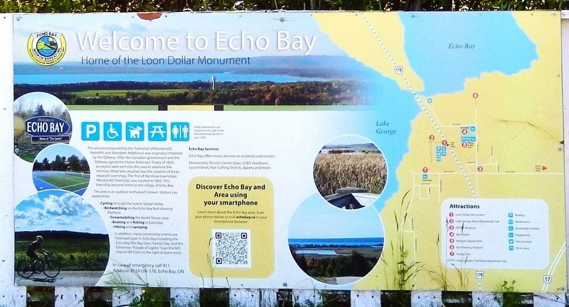
The area encompassed by the Township of Macdonald, Meredith and Aberdeen Additional was originally inhabited by the Ojibway. After the Canadian government and the Ojibway signed the Huron-Robinson Treaty of 1850, surveyors were sent into this area to examine the territory. What later resulted was the creation of three separate townships. The first of the three townships, Macdonald Township, was created in 1863. This township became home to the village of Echo Bay.
The area is an outdoor enthusiast's dream. Visitors can experience:
• Cycling through the scenic Sylvan ValleyIn addition, many community events are held each year in Echo Bay including the Echo Bay Elks Bay Days, Family Day, and the Christmas "Parade of Lights"
• Birdwatching on the Echo Bay Bird Viewing Platform
• Snowmobiling the North Shore Loop
• Boating and fishing in Echo Bay
• Hiking and camping
Erected by Village of Echo Bay.
Topics. This historical marker is listed in these topic lists: Indigenous Peoples and Communities • Parks & Recreational Areas • Settlements & Settlers. A significant historical year for this entry is 1863.
Location. 46° 29.304′ N, 84° 4.428′ W.
this page online

Regionally, this marker is in the Sault Ste. Marie and Algoma Area and in Northern Ontario. It is also in Central Canada. Globally, it is in North America, in the Great North Woods, on the Great Lakes, on Lake Superior’s North Shore, in the Western Hemisphere, in the Western World, and in the Anglosphere. Historically, it finds itself in what was once a British colony, the Viceroyalty of New France, the Haudenosaunee (Iroquois) Confederacy, and Rupert’s Land.
Other nearby markers. At least 4 other markers are within 23 kilometers of this marker, measured as the crow flies: Echo Bay Celebrates Canada's Iconic “Loonie” / Célébre le « huard », pièce emblématique du Canada (a few steps from this marker); "Ripple Rock"
Related markers. Click here for a list of markers that are related to this marker.
Also see . . .
1. Robinson Huron Treaty (Wikipedia).
Excerpt: The first Robinson Treaty for the Lake Huron region, commonly called Robinson Huron Treaty, was entered into agreement on September 9, 1850, at Sault Ste. Marie, Ontario, between Ojibwa Chiefs inhabiting the Northern Shore of Lake Superior from Batchawana Bay to Sault Ste. Marie and the Ojibwa Chiefs inhabiting the eastern and northern shores of Lake Huron from Sault Ste. Marie to Penetanguishene, and The Crown, represented by a delegation headed by William Benjamin Robinson.(Submitted on May 6, 2025, by Cosmos Mariner of Cape Canaveral, Florida.)These principal men on behalf of their respective Tribes or Bands, voluntarily surrendered, ceded, granted, and convey unto Her Majesty, her heirs and successors for ever, all their right, title, and interest to, and in the whole of, the territory above described, together with the Islands in the said Lakes, opposite to the Shores thereof, and
inland to the Height of land which separates the Territory covered by the charter of the Honorable Hudson Bay Company from Canada; as well as all unconceded lands within the limits of Canada West to which they have any just claim.
2. Echo Bay: A Look at Our History (Echo Bay Municipal website).
Excerpt: This township first witnessed permanent settlement during the mid-nineteenth century when geologists filtered into the territory to determine the quality and quantity of suspected minerals. This occurred as a result of the mining boom which transpired throughout Canada West. When mining did not prosper in this area, people ventured into lumbering and agriculture.(Submitted on May 6, 2025, by Cosmos Mariner of Cape Canaveral, Florida.)Settlement stretched throughout the region and by the 1860s visible communities were located in Sylvan Valley, Bar River, and Echo Bay. With the construction of a Canadian Pacific Railway station in Echo Bay in 1888, the village of Echo Bay expanded as businesses and homes were erected around the station. The C.P.R. station remained the centre of activity well into the twentieth century carrying passengers and freight alike. The C.P.R. closed the Echo Bay station in 1977.
Aside from the train station, Echo Bay boasted an active harbour on the shore of Lake George whereby boats trading between Lake Superior and the lower lakes often anchored. This contributed to the bustling of this little village.
Credits. This page was last revised on May 6, 2025. It was originally submitted on May 5, 2025, by Cosmos Mariner of Cape Canaveral, Florida. This page has been viewed 170 times since then and 47 times this year. Photos: 1, 2. submitted on May 6, 2025, by Cosmos Mariner of Cape Canaveral, Florida.
