Batchawana Bay in Algoma District, Ontario — Central Canada (North America)
Chippewa Falls
Halfway Point on the Trans-Canada Highway
⎯⎯⎯
Chutes de Chippewa
Au beau milieu de la Transcanadienne
Photographed by Cosmos Mariner, June 12, 2024
1. Chippewa Falls / Chutes de Chippewa Marker

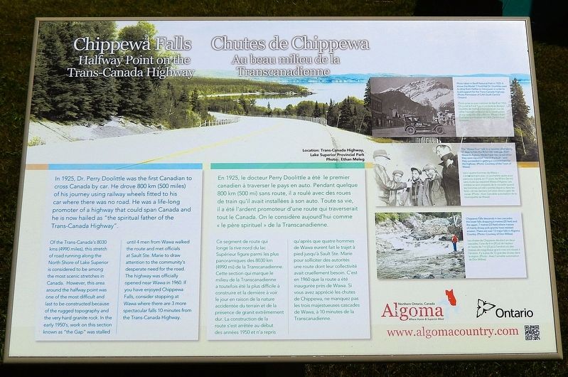
Of the Trans-Canada's 8030 kms (4990 miles), this stretch of road running along the North Shore of Lake Superior is considered to be among the most scenic stretches in Canada. However, this area around the halfway point was one of the most difficult and last to be constructed because of the rugged topography and the very hard granite rock. In the early 1950's, work on this section known as “the Gap” was stalled until 4 men from Wawa walked the route and met officials at Sault Ste. Marie to draw attention to the community's desperate need for the road. The highway was officially opened near Wawa in 1960. If you have enjoyed Chippewa Falls, consider stopping at Wawa where there are 3 more spectacular falls 10 minutes from the Trans-Canada Highway.
this page online
Ce segment de route qui longe la rive nord du lac Supérieur figure parmi les plus panoramiques des 8030 km (4990 mi) de la Transcanadienne. Cette section qui marque le milieu de la Transcanadienne a toutefois été la plus difficile à construire et la dernière à voir le jour en raison de la nature accidentée du terrain et de la présence de granit extrêmement dur. La construction de la route s'est arrêtée au début des années 1950 et n'a repris qu'après que quatre hommes de Wawa eurent fait le trajet à pied jusqu'à Sault Ste. Marie pour solliciter des autorités une route dont leur collectivité avait cruellement besoin. C'est en 1960 que la route a été inaugurée près de Wawa. Si vous avez apprécié les chutes de Chippewa, ne manquez pas les trois majestueuses cascades de Wawa, à 10 minutes de la Transcanadienne.
Topics.
Courtesy CAA South Central Ontario
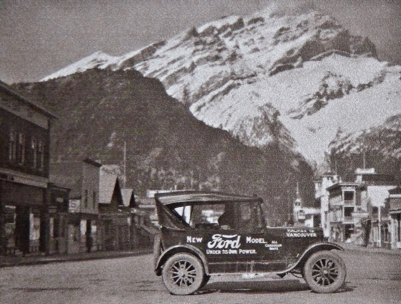
2. Marker detail: Banff National Park in 1925
Photo taken in Banff National Park in 1925. It shows the Model T Ford that Dr. Doolittle used to drive from Halifax to Vancouver in order to build support for the Trans-Canada Highway. • • • Photo prise au parc national de Banff en 1925. On y voit la Ford T qu'a conduite le docteur Doolittle de Halifax à Vancouver en vue de rallier l'opinion en faveur de la construction d'une route transcanadienne.
Location. 46° 55.701′ N, 84° 25.526′ W. Marker is in Batchawana Bay, Ontario, in Algoma District. It is on Trans-Canada Highway (Provincial Highway 17) 0.8 kilometers west of Whispering Pines Road, on the right when traveling west. The marker is located in the Chippewa Falls Rest Area. Touch for map. Marker is at or near this postal address: 8632 Trans-Canada Highway, Batchawana Bay ON P0S 1A0, Canada. Touch for directions.

Regionally, this marker is in the Sault Ste. Marie and Algoma Area and in Northern Ontario. It is also in Central Canada. Globally, it is in North America, in the Great North Woods, on the Great Lakes, on Lake Superior’s North Shore, in the Western Hemisphere, in the Western World, and in the Anglosphere. Historically, it finds itself in what was once a British colony, the Viceroyalty of New France, the Haudenosaunee (Iroquois) Confederacy, and Rupert’s Land.
Other nearby markers. At least one other marker is within walking distance of this marker:

Courtesy of the Town of Wawa
3. Marker detail: The “Wawa Four”
The “Wawa Four” talk to a reporter after taking 17 days to hike the 90 km (56 mile) gap from Wawa to Agawa. Media hype was raised when they were reported "lost in the bush" and they succeeded in getting a commitment for the highway. • • • Les « quatre hommes de Wawa » s'entretiennent avec un journaliste après avoir parcouru à pied, en 17 jours, les 90 km (56 mi) sans route qui séparent Wawa d'Agawa. Les médias se sont emparés de la nouvelle quand les hommes ont été « portés disparus dans les bois » et ces derniers ont ainsi obtenu gain de cause.
Also see . . .
1. Father of the Trans-Canada Highway's cross-Canada excursion remembered.
(The Canadian Press, July 17, 2017) Excerpt: Perry Doolittle had a vision of connecting Canadians from coast to coast when he backed the tires of his Ford Model T into the Atlantic Ocean at the outset of a cross-country excursion almost a century ago. Doolittle — a physician and inventor who founded the Canadian Automobile Association in 1920 — travelled across Canada in a Tin Lizzie to promote his ambitious goal, leaving from Halifax on Sept. 8, 1925. The roughly 8,000-kilometre excursion was mostly over dirt roads, and in some areas the vehicle had to be driven on train tracks because there were no roads. Doolittle, who died in 1933 at the age of 72, did not live long enough to see his vision realized. The now-vital Trans-Canada Highway was approved by Parliament in 1949, and construction began a year later. It was officially opened by Prime Minister John Diefenbaker in 1962, although much of it was still gravel at the time. The highway — which stretches from St. John's,(Submitted on May 10, 2025, by Cosmos Mariner of Cape Canaveral, Florida.)N.L., to Victoria, B.C. — was completed to standard in 1971 and came with a $1-billion price tag.Photographed by Cosmos Mariner, June 12, 20244. Chippewa Falls / Chutes de Chippewa MarkerThe marker is in the Chippewa Falls Rest Area.

2. Trans-Canada Highway (Wikipedia).
Excerpt: Early on, much of the route of the Trans-Canada Highway was first explored in order to construct the Canadian Pacific Railway in the late 19th century, a route which much of the mainline highway route later ended up following. Upon its original completion, the Trans-Canada Highway was the longest uninterrupted highway in the world.(Submitted on May 10, 2025, by Cosmos Mariner of Cape Canaveral, Florida.)

Photographed by Cosmos Mariner, June 12, 2024
5. Chippewa Falls / Chutes de Chippewa
Photo taken from the Chippewa Falls overlook, on the west side of the rest area. Text from the historical marker photo caption: • • • Les chutes de Chippewa dévalent en deux cascades, l'une de 6 m (20 pi) de hauteur et l'autre de 7 m (23 pi) à l'endroit où des masses de magnifique granit rose ont résiste à l'érosion. Il y a plus de 13 grandes chutes dans la région.
Chippewa Falls descends in two cascades: the lower falls dropping 6 metres (20 feet) and the upper, 7 metres (23 feet) where masses of mainly showy pink granite have resisted erosion. There are over 13 major falls in Algoma Country.
Credits. This page was last revised on May 10, 2025. It was originally submitted on May 9, 2025, by Cosmos Mariner of Cape Canaveral, Florida. This page has been viewed 177 times since then and 40 times this year. Photos: 1, 2, 3, 4, 5. submitted on May 10, 2025, by Cosmos Mariner of Cape Canaveral, Florida.
