Schiller Park in Cook County, Illinois — The American Midwest (Great Lakes)
Former Site of the Motykiewicz Farm

Photographed by Sean P. Flynn, May 13, 2025
1. Former Site of the Motykiewicz Farm Marker
Erected by Schiller Park Historical Commission.
Topics. This historical marker is listed in these topic lists: Agriculture • Indigenous Peoples and Communities. A significant historical year for this entry is 1920.
Location. 41° 58.363′ N, 87° 51.737′ W. Marker is in Schiller Park, Illinois, in Cook County. It is on River Road (Illinois Route 171) south of Foster Avenue, on the right when traveling south. Touch for map. Marker is at or near this postal address: 5100 River Road, Schiller Park IL 60176, United States of America. Touch for directions.

Regionally, this marker is in Greater Chicago. It is also in the American Midwest. Globally, it is in North America, on the Great Lakes, in the Western Hemisphere, in the Western World, and in the Anglosphere. Historically, it finds itself in what was once the Viceroyalty of New France, the territory of the Mississippian Culture, and the Northwest Territory.
Other nearby markers. At least 8 other markers are within 2 miles of this marker, measured as the crow
this page online
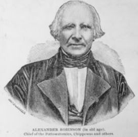
Regarding Former Site of the Motykiewicz Farm. Alexander Robinson was a Native American leader who helped negotiate the 1812 Treaty of St. Louis and the 1829 Treaty of Prairie du Chien, the latter of which rewarded him with a large tract of land along the Des Plaines River. He is buried across the river in a family plot in the forest preserve that bears his name.
Also see . . . Schiller Park Historic Sites map.
Excerpt: "The George Motykiewicz farm located on River Road was a busy truck farm. If they weren’t operating their popular roadside stand offering fruits, vegetables and fresh eggs, it was transported to the market in Chicago."(Submitted on May 13, 2025, by Sean P. Flynn of Oak Park, Illinois.)

Photographed by Sean P. Flynn, May 13, 2025
2. Former Site of the Motykiewicz Farm Marker

Photographed by Sean P. Flynn, May 13, 2025
3. Former Site of the Motykiewicz Farm Marker
The south-facing view from Foster Avenue
Keystone-Mast Collection, UCR/California Museum of Photography, Univ. of California at Riverside
4. Alexander Robinson (Che-Che-Pin-Qua)
A drawing of Alexander Robinson from late in his life.
Credits. This page was last revised on May 13, 2025. It was originally submitted on May 13, 2025, by Sean P. Flynn of Oak Park, Illinois. This page has been viewed 234 times since then and 62 times this year. Photos: 1, 2, 3. submitted on May 13, 2025, by Sean P. Flynn of Oak Park, Illinois. 4. submitted on May 7, 2024, by Sean P. Flynn of Oak Park, Illinois.
