Liberty in Clay County, Missouri — The American Midwest (Upper Plains)
Ruth Stocksdale Park
Photographed by Erika Brant, November 20, 2024
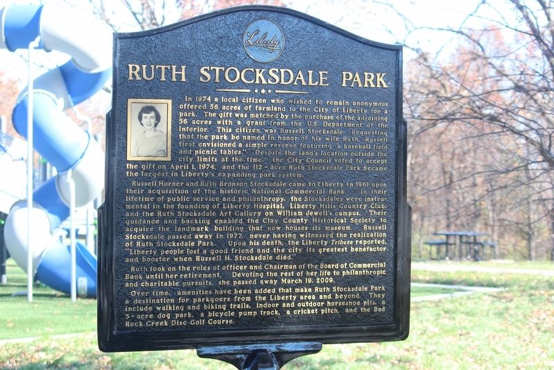
1. Ruth Stocksdale Park Marker
In 1974 a local citizen who wished to remain anonymous offered 56 acres of farmland to the City of Liberty for a park. The gift was matched by the purchase of the adjoining 56 acres with a grant from the US Department of the Interior. This citizen was Russell Stocksdale Requesting that the park be named in honor of his wife Ruth. Russell first envisioned a simple reserve featuring a baseball field and picnic tables." Despite the land's location outside the city limits at the time. the City Council voted to accept the gift on April 1, 1974, and the 112-acre Ruth Stocksdale Park became the largest in Liberty's expanding park system.
Russell Horner and Ruth Bronson Stocksdale came to Liberty in 1961 upon their acquisition of the historic National Commercial Bank. In their lifetime of public service and philanthropy, the Stocksdales were instrumental in the founding of Liberty Hospital, Liberty Hills Country Club, and the Ruth Stocksdale Art Gallery on William Jewell's campus. Their guidance and backing enabled the Clay County Historical Society to acquire the landmark building that now houses its museum. Russell Stocksdale
this page online
Ruth took on the roles of officer and Chairman of the Board of Commercial Bank until her retirement. Devoting the rest of her life to philanthropic and charitable pursuits she passed away March 19. 2009.
Over time, amenities have been added that make Ruth Stocksdale Park a destination for parkgoers from the Liberty area and beyond. They include walking and biking trails, indoor and outdoor horseshoe pits, a 3-acre dog park, a bicycle pump track, a cricket pitch, and the Bad Rock Creek Disc Golf Course.
Erected 2024 by City of Liberty, MO.
Topics. This historical marker is listed in these topic lists: Charity & Public Work • Parks & Recreational Areas • Women. A significant historical date for this entry is April 1, 1974.
Location. 39° 14′ N, 94° 23.317′ W. Marker is in Liberty, Missouri, in Clay County. It can be reached from Stocksdale Park Drive east of South La Frenz Road,

Photographed by Erika Brant, November 2024
2. Ruth Stocksdale Park Marker

Regionally, this marker is in the Missouri River Corridor and in Greater Kansas City. It is also in the American Midwest, in the Lewis & Clark Corridor, and in the Corn Belt. Globally, it is in North America, the Western Hemisphere, the Western World, and the Anglosphere. Historically, it finds itself in what was once the territory of the Mississippian Culture, the Louisiana Purchase, and the Antebellum South.
Other nearby markers. At least 8 other markers are within 2 miles of this marker, measured as the crow flies: Martha Lafite Thompson Nature Sanctuary (approx. 1.2 miles away); Ruth Ewing (approx. 1½ miles away); Battle of Liberty / Blue Mills Landing (approx. 1.6 miles away); The Trenches On The Hill (approx. 1.7 miles away); Grand River Baptist Church (approx. 1.7 miles away); Mass Grave Site (approx. 1.7 miles away); Civil War Memorial (approx. 1.7 miles away); "The Old Graveyard" (approx. 1.7 miles away). Touch for a list and map of all markers in Liberty.
Credits. This page was last revised on May 14, 2025. It was originally submitted on May 14, 2025, by Erika Brant of Liberty, Missouri. This page has been viewed 248 times since then and 49 times this year. Photos: 1, 2. submitted on May 14, 2025, by Erika Brant of Liberty, Missouri. • Devry Becker Jones was the editor who published this page.
