
Tebbetts in Callaway County, Missouri — The American Midwest (Upper Plains)
History of Tebbetts
Photographed by John Ridley, April 28, 2023
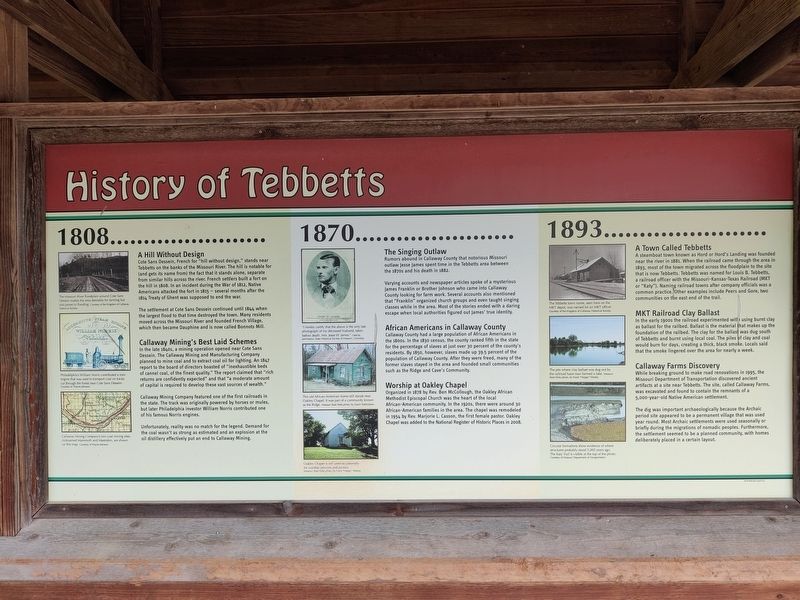
1. History of Tebbetts Marker
1808…
A Hill Without Design
Cote Sans Dessein, French for "hill without design," stands near Tebbetts on the banks of the Missouri River. The hill is notable for (and gets its name from) the fact that it stands alone, separate from similar hills across the river. French settlers built a fort on the hill in 1808. In an incident during the War of 1812, Native Americans attacked the fort in 1815–several months after the 1814 Treaty of Ghent was supposed to end the war.
The settlement at Cote Sans Dessein continued until 1844 when the largest flood to that time destroyed the town. Many residents moved across the Missouri River and founded French Village, which then became Dauphine and is now called Bonnots Mill.
Callaway Mining's Best Laid Schemes
In the late 1840s, a mining operation opened near Cote Sans Dessein. The Callaway Mining and Manufacturing Company planned to mine coal and to extract coal oil for lighting. An 1847 report to the board of directors boasted "inexhaustible beds of cannel coal, of the finest quality." The report claimed that "rich returns are confidently expected" and that "a moderate amount
this page online
Callaway Mining Company featured one of the first railroads in the state. The track was originally powered by horses or mules, but later Philadelphia investor William Norris contributed one of his famous Norris engines.
Unfortunately, reality was no match for the legend. Demand for the coal wasn't as strong as estimated and an explosion at the oil distillery effectively put an end to Callaway Mining.
1870…
The Singing Outlaw
Rumors abound in Callaway County that notorious Missouri outlaw Jesse James spent time in the Tebbetts area between the 1870s and his death in 1882.
Varying accounts and newspaper articles spoke of a mysterious James Franklin or Brother Johnson who came into Callaway County looking for farm work. Several accounts also mentioned that "Franklin" organized church groups and even taught singing classes while in the area. Most of the stories ended with a daring escape when local authorities figured out James' true identity.
African Americans in Callaway County
Callaway County had a large population of African Americans in the 1800s. In the 1830 census, the county ranked fifth in the state for the percentage of slaves at just over 30 percent of the county's residents. By 1850, however, slaves made up 39.5 percent of the population of Callaway County. After they were freed, many of the former slaves stayed in the area and founded small communities such as the Ridge and Cave's Community.
Worship at Oakley Chapel
Organized in 1878 by Rev. Ben McCollough, the Oakley African Methodist Episcopal Church was the heart of the local African-American community. In the 1920s, there were around 30 African-American families in the area. The chapel was remodeled in 1954 by Rev. Marjorie L. Casson, the first female pastor. Oakley Chapel was added to the National Register of Historic Places in 2008.
1893…
A Town Called Tebbetts
A steamboat town known as Hord or Hord's Landing was founded near the river in 1881. When the railroad came through the area in 1893, most of the town migrated across the floodplain to the site that is now Tebbetts. Tebbetts was named for Louis B. Tebbetts, a railroad officer with the Missouri-Kansas-Texas Railroad (MKT or "Katy"). Naming railroad towns after company officials was a common practice. Other examples include Peers and Gore, two communities on the east end of the trail.
MKT Railroad Clay Ballast
In the early 1900s the railroad experimented with using burnt clay as ballast for the railbed. Ballast is the material that makes up the foundation of the railbed. The clay for the ballast was dug south of Tebbetts and burnt using local coal. The piles of clay and coal would burn for days, creating a thick, black smoke. Locals said that the smoke lingered over the area for nearly a week.
Callaway Farms Discovery
While breaking ground to make road renovations in 1995, the Missouri Department of Transportation discovered ancient artifacts near Tebbetts. The site, called Callaway Farms, was excavated and found to contain the remnants of a 5,000-year-old Native American settlement.
The dig was important archaeologically because the Archaic period site appeared to be a permanent village that was used year round. Most Archaic settlements were used seasonally or briefly during the migrations of nomadic peoples. Furthermore, the settlement seemed to be a planned community, with homes deliberately placed in a certain layout.
Erected by Missouri Department of Natural Resources.
Topics and series. This historical marker is listed in these topic lists: African Americans • Anthropology & Archaeology • Indigenous Peoples and Communities • Religion & Religious Structures. In addition, it is included in the African Methodist Episcopal (AME) Church series list. A significant historical year for this entry is 1808.
Location. 38° 36.63′ N, 91° 58.881′ W. Marker is in Tebbetts, Missouri, in Callaway County. It is on State Highway 94 east of County Highway AA, on the right when traveling west. Touch for map. Marker is at or near this postal address: 5065 Hwy 94, Tebbetts MO 65080, United States of America. Touch for directions.

Regionally, this marker is in Little Dixie and in the Missouri River Corridor. It is also in the American Midwest, in the Lewis & Clark Corridor, and in the Corn Belt. Globally, it is in North America, the Western Hemisphere, the Western World, and the Anglosphere. Historically, it finds itself in what was once the territory of the Mississippian Culture, the Louisiana Purchase, and the Antebellum South.
Other nearby markers. At least 8 other markers are within 8 miles of this marker, measured as the crow flies: Fur Trading in Missouri (approx. 1.3 miles away); Battle of Côte Sans Dessein (approx. 1½ miles away); M901 ITV "Hammer Head" (approx. 6½ miles away); 75 mm Pack Howitzer on M8 Carriage (approx. 6½ miles away); Spanish-American War Memorial (approx. 6½ miles away); F-15 Eagle Fighter (approx. 6½ miles away); M551 Sheridan Tank (approx. 6½ miles away); Katy Railroad (approx. 7½ miles away). Touch for a list and map of all markers in Tebbetts.
Credits. This page was last revised on May 18, 2025. It was originally submitted on May 16, 2025, by John Ridley of Chelsea, Michigan. This page has been viewed 354 times since then and 78 times this year. Photo 1. submitted on May 16, 2025, by John Ridley of Chelsea, Michigan. • Devry Becker Jones was the editor who published this page.
Editor’s want-list for this marker. A wide shot of the marker in context. • Can you help?
